Blackwater Bay Map King’s Landing, Dragonstone, Driftmark & Sea Routes
King’s Landing, Dragonstone, Driftmark, naval routes and capital pressure
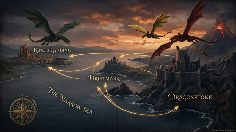
Blackwater Bay Map — Blackwater Bay is the water engine of the Crownlands. It links King’s Landing to Dragonstone, Driftmark and the Narrow Sea, which means every fleet, blockade, dragon flight and royal claim around the capital is shaped by this bay.
Blackwater Bay is the water engine of the Crownlands. It links King’s Landing to Dragonstone, Driftmark and the Narrow Sea, which means every fleet, blockade, dragon flight and royal claim around the capital is shaped by this bay.
What This Blackwater Bay Map Shows
Use these cards as the two-minute orientation before opening the route map or reading the full atlas guide.
Explore the Main Locations and Pressure Points
Tap a location to see its role, route connection and why it matters inside the wider ThroneAtlas network.
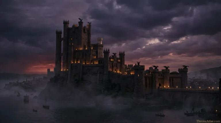
King’s Landing
The capital controls the political prize, but its water edge also creates exposure.
Complete Blackwater Bay Map Guide
A strong ThroneAtlas page should explain what the visitor is seeing, why the route matters, and where the reader should go next.
How to read the Blackwater Bay map
Read Blackwater Bay as a circle of pressure around King’s Landing. The city is not simply inland politics with a harbor attached. Its survival depends on river access, sea access, fleet defense and the loyalty of houses along the Crownlands shore. That is why this bay matters in both Game of Thrones and House of the Dragon.
The bay also makes Dragonstone feel much closer than it looks on a flat map. The Targaryen seat is across water, not across a continent. That geography explains why the island becomes a recurring launch point for claimants, dragonriders and exiled royal power.
Why the bay connects so many storylines
Blackwater Bay connects battles because it connects incentives. Whoever holds King’s Landing wants the bay protected. Whoever holds Dragonstone wants the bay open. Whoever holds Driftmark can use ships to influence both. This triangle is the simplest way to understand why the region keeps returning to the center of Westerosi conflict.
For readers, this makes the map a useful hub page. It naturally links to King’s Landing, Dragonstone, Driftmark, the Battle of the Gullet, the Dance of the Dragons and naval routes in the Narrow Sea. A searcher who lands here should feel that the page gives them a complete doorway into the Crownlands coast.
Best route for first-time visitors
Begin at King’s Landing, move east across the bay to Dragonstone, then west toward Driftmark and the Gullet. Once those three places are fixed in your head, every major route becomes easier: blockade lines, dragon flights, merchant lanes, battle approaches and escape paths all pass through the same water system.
This page deliberately keeps the language clear because many visitors are not looking for a lore essay. They want to know where Blackwater Bay is, what it touches and why it keeps changing the fate of kings, queens and fleets.
Core Locations at a Glance
These are the locations that carry the most reader value for this topic. Each card works as a bridge to another ThroneAtlas page, so the visitor can keep moving through the atlas instead of reaching a dead end.
King’s Landing
The capital controls the political prize, but its water edge also creates exposure.
Dragonstone
Dragonstone is close enough to threaten the capital yet isolated enough to resist it.
Driftmark
Driftmark gives the bay a second Valyrian anchor, one based on ships rather than throne rooms.
Location, Role and Story Connection
This table is built for scanners, featured-snippet style clarity and internal editorial strength.
| Location | Map Role | Connected Routes | Why It Matters |
|---|---|---|---|
| King’s Landing | Capital harbor | Red Keep · Blackwater Rush | The capital controls the political prize, but its water edge also creates exposure. |
| Dragonstone | Targaryen island | Dragonmont · royal seat | Dragonstone is close enough to threaten the capital yet isolated enough to resist it. |
| Driftmark | Velaryon island | High Tide · fleet power | Driftmark gives the bay a second Valyrian anchor, one based on ships rather than throne rooms. |
| The Gullet | Eastern gate | Sea lane · battle route | The Gullet turns Blackwater Bay into a wider naval theater connected to the Narrow Sea. |
| Crownlands Coast | Support zone | Rosby · Duskendale · Massey’s Hook | Coastal settlements help explain how armies, supplies and ravens move around the capital. |
| Narrow Sea | Outer route | Essos · trade · invasion lanes | The bay never stands alone; it opens into the world beyond Westeros. |
Blackwater Bay Map Questions
Blackwater Bay is the major bay beside King’s Landing, connecting the capital to Dragonstone, Driftmark, the Gullet and the Narrow Sea.
It controls capital access, fleet movement, trade routes, battle approaches and the relationship between King’s Landing and nearby island powers.
Dragonstone lies at the eastern edge of the Blackwater Bay region, close enough to influence the capital while remaining a defensible island seat.