Game of Thrones Maps Interactive Atlas of Westeros & Essos
Explore the geography behind every throne, journey and war: the Seven Kingdoms, the Free Cities, the Dothraki Sea, Slaver’s Bay, noble strongholds, battlefields and the routes that carried characters across the Known World.
Game of Thrones maps show the Known World of A Song of Ice and Fire and HBO’s screen adaptations, led by Westeros in the west and Essos across the Narrow Sea. This interactive ThroneAtlas hub lets readers search locations, explore noble houses, follow characters, find major battles and open focused map guides from a single visual atlas.
Explore Westeros, Essos, Houses, Battles & Routes
Use the atlas like a maester’s map table. Select a layer, search an entity or click a pin to continue into the connected ThroneAtlas guide.
Map Layers
Find Winterfell, Dragonstone, Braavos, a great house or a battle by name.
Reveal only locations, houses, characters, battles, lore or supporting maps.
Select a marker to read its geographic role and jump to its related guide.
Use the map cards and timelines below to deepen the reader journey.
Westeros vs Essos: The Two Main Continents
The story becomes easier to follow when the western struggle for the Iron Throne is seen alongside the vast eastern journeys that shape Daenerys, Arya and the history of Valyria.
Start With the Maps That Define the Story
These are the atlas entry points that give readers the clearest understanding of the world before they move into house territories, journeys and battles.
Westeros Map: Complete Guide to the Seven Kingdoms
Explore the continent where the central war for rule unfolds: Winterfell, King’s Landing, Dragonstone, the Riverlands, the Wall, the Reach and Dorne — linked by roads, alliances and conflict.
Essos Map
The eastern continent of Braavos, Pentos, Meereen, the Dothraki Sea and Old Valyria.
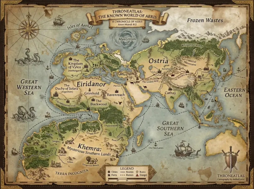
Known World Map
See Westeros and Essos together with the Narrow Sea and outer mysteries of the mapped world.
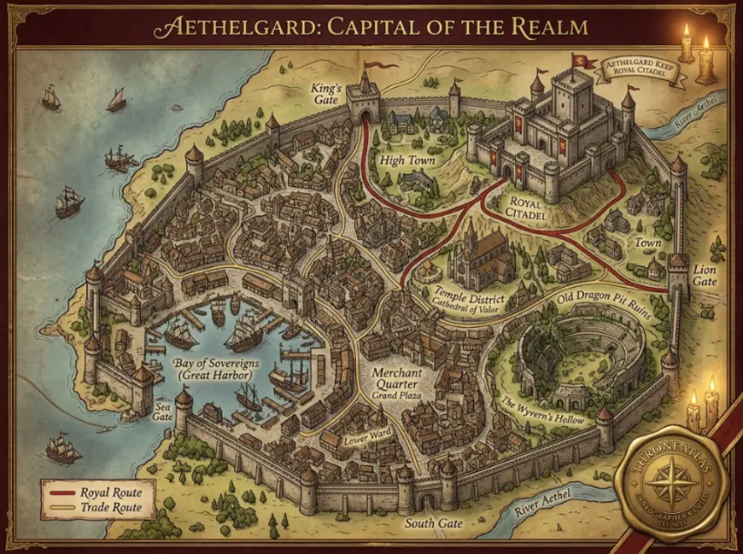
King’s Landing Map
The capital, the Red Keep, royal intrigue and the bay that determines major battles.
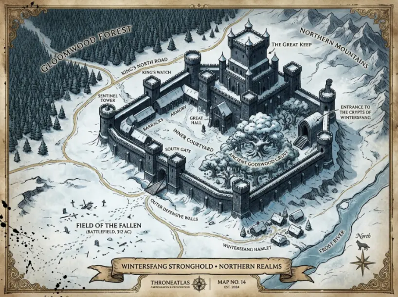
Winterfell Map
The Stark stronghold, northern political heart and final defense against the dead.
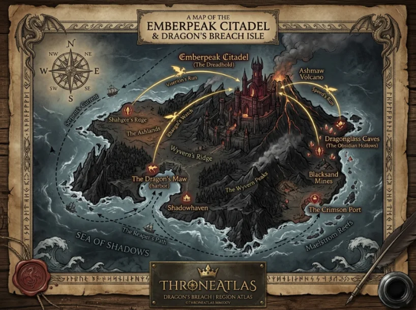
Dragonstone Map
Ancient Valyrian fortress, dragonstone seat and strategic island near the capital.
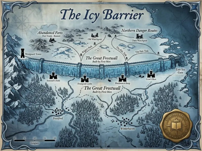
The Wall Map
Castle Black, Eastwatch and the frozen boundary dividing the realm from the far north.
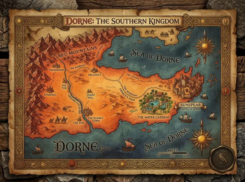
Dorne Map
Sunspear, desert routes, mountain barriers and the realm ruled by House Martell.
House of the Dragon Map
The Dance of the Dragons mapped through Dragonstone, King’s Landing and contested battle routes.
All Locations
Continue beyond the core maps into castles, cities, ruins, islands and regional waypoints.
Key Regions of the Known World
Geography decides who can march, who can trade, who can defend a throne and which places become impossible to ignore.
| Region | Continent | Power Center | Associated House | Strategic Importance | Explore |
|---|---|---|---|---|---|
| The North | Westeros | Winterfell | House Stark | Largest northern domain; gateway to the Wall. | View |
| Crownlands | Westeros | King’s Landing | Royal Crown | Capital, Blackwater Bay and access to Dragonstone. | View |
| Riverlands | Westeros | Riverrun | House Tully | Crossroads of armies, rivers and contested castles. | View |
| The Vale | Westeros | The Eyrie | House Arryn | Mountain defense and controlled passes. | View |
| The Westerlands | Westeros | Casterly Rock | House Lannister | Wealth, ports and western power. | View |
| Dorne | Westeros | Sunspear | House Martell | Mountain-desert defenses and southern independence. | View |
| Free Cities | Essos | Braavos / Pentos | City-states | Trade, exile, banking and Faceless Men routes. | View |
| Slaver’s Bay | Essos | Meereen | Changing rule | Central to Daenerys’s liberation and governing arc. | View |
| Beyond the Wall | North | Hardhome | Free Folk | The supernatural threat and the Long Night route. | View |
How the Map Changes Through Game of Thrones & House of the Dragon
The same castles and seas take on new meaning as the story shifts from royal conflict to dragon war and existential survival.
S1–2
The War of Five Kings Opens the Map
Winterfell, King’s Landing, Dragonstone, Pyke, Harrenhal and Qarth define a fractured world of competing claims.
S3–4
The Riverlands Collapse While Essos Expands
The Twins become infamous, Castle Black becomes vital and Daenerys’s eastern campaign moves into Slaver’s Bay.
S5–6
Hardhome, Braavos and the Return of the Starks
Jon confronts the dead beyond the Wall, Arya’s path develops in Braavos and Winterfell becomes the northern battleground.
S7–8
Dragonstone, Winterfell and the Fall of the Capital
Daenerys reaches Westeros, the dead move south, Winterfell hosts the Long Night and King’s Landing becomes the final ruin.
S3
The Dance of the Dragons Returns to the Map
House of the Dragon Season 3 debuts June 21, 2026, carrying the Targaryen civil war deeper across Westeros after the conflict of Season 2.
Understanding the Geography Behind the Throne
What Is the Game of Thrones Map?
The Game of Thrones map represents the Known World depicted in George R.R. Martin’s A Song of Ice and Fire universe and its television adaptations. For most readers and viewers, the world is understood through two major landmasses: Westeros, where the contest for the Iron Throne dominates political life, and Essos, where exile, trade, slavery, prophecy and dragons reshape the western story from afar.
Why Westeros Is More Than a List of Kingdoms
Westeros is a continent shaped by distance and defensibility. The North is enormous and difficult to control from the capital. The Riverlands sit exposed between competing armies. The Vale is protected by its mountain approaches. Dragonstone can threaten King’s Landing from the sea. Dorne’s terrain reinforces its political independence. Reading the map makes the conflicts of House Stark, House Lannister, House Baratheon, House Targaryen and House Martell more coherent because each family’s choices are constrained by geography.
- Winterfell anchors northern rule, memory and military return.
- King’s Landing is both capital and vulnerable coastal prize.
- Dragonstone is a Targaryen symbol and naval launch point.
- The Wall turns a boundary into the central defense of the living.
Why Essos Changes the Meaning of Westeros
Essos expands the atlas beyond the throne. Pentos frames the Targaryen exile. The Dothraki Sea transforms Daenerys’s identity and military power. Astapor and Meereen define her liberation-and-rule arc. Braavos gives Arya a new path and introduces the Iron Bank and Faceless Men. Old Valyria supplies the lost historical center behind dragons, Valyrian blood and the ruins that haunt the wider world.
This is why a true Game of Thrones maps hub cannot stop at a map of the Seven Kingdoms. It must connect western royal politics with eastern journeys, trade routes and historical origins.
How to Read Journeys and Battles Through the Map
Character routes and battles convert geography into story. Jon Snow’s journey is inseparable from the Wall, Hardhome, Winterfell and Dragonstone. Arya’s journey makes the Riverlands and Braavos central to her transformation. Daenerys moves from Essos to Dragonstone and finally to King’s Landing. The Battle of Blackwater only makes sense when the bay, city defenses and sea approach are visible together.
Use this page as the central atlas hub, then continue into character routes, major battles, noble houses and individual location maps for deeper context.
Frequently Asked Questions About Game of Thrones Maps
Continue Through the Connected Atlas
Every map should lead somewhere useful: into a place, a house, a battle, a journey or the historical lore that explains it.