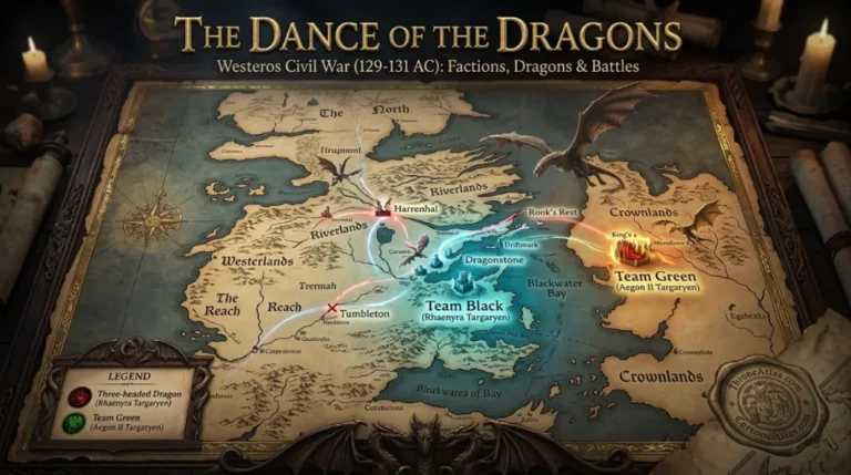
House of the Dragon Season 3 Map: Every Major Location, Battle & Route
A spoiler-rich, map-first guide to the complete aired third season—showing how the Dance spreads from Dragonstone and the Gullet into King’s Landing, Harrenhal, the Riverlands and Tumbleton.
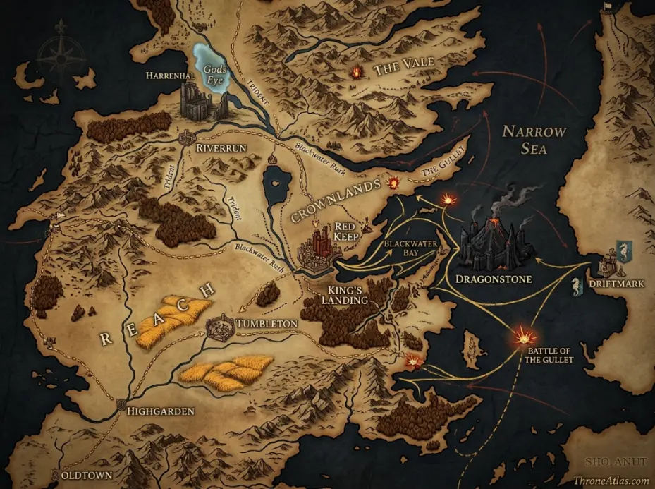
The House of the Dragon Season 3 map is centered on six strategic zones: Dragonstone, the Gullet, King’s Landing, Harrenhal and the Gods Eye, the Reach/Tumbleton corridor, and the roads and sea lanes connecting them. The season begins with the Battle of the Gullet, quickly shifts political control of King’s Landing, and ends with the war’s center of gravity moving toward Tumbleton while surviving dragons and rival claimants keep the realm divided.
House of the Dragon Season 3 Map at a Glance
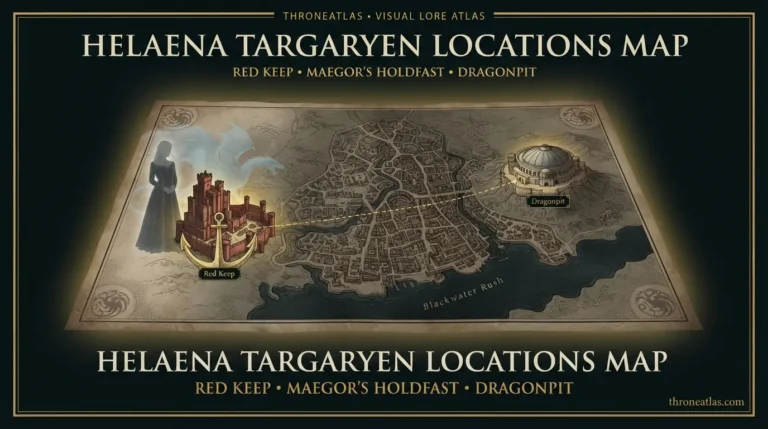
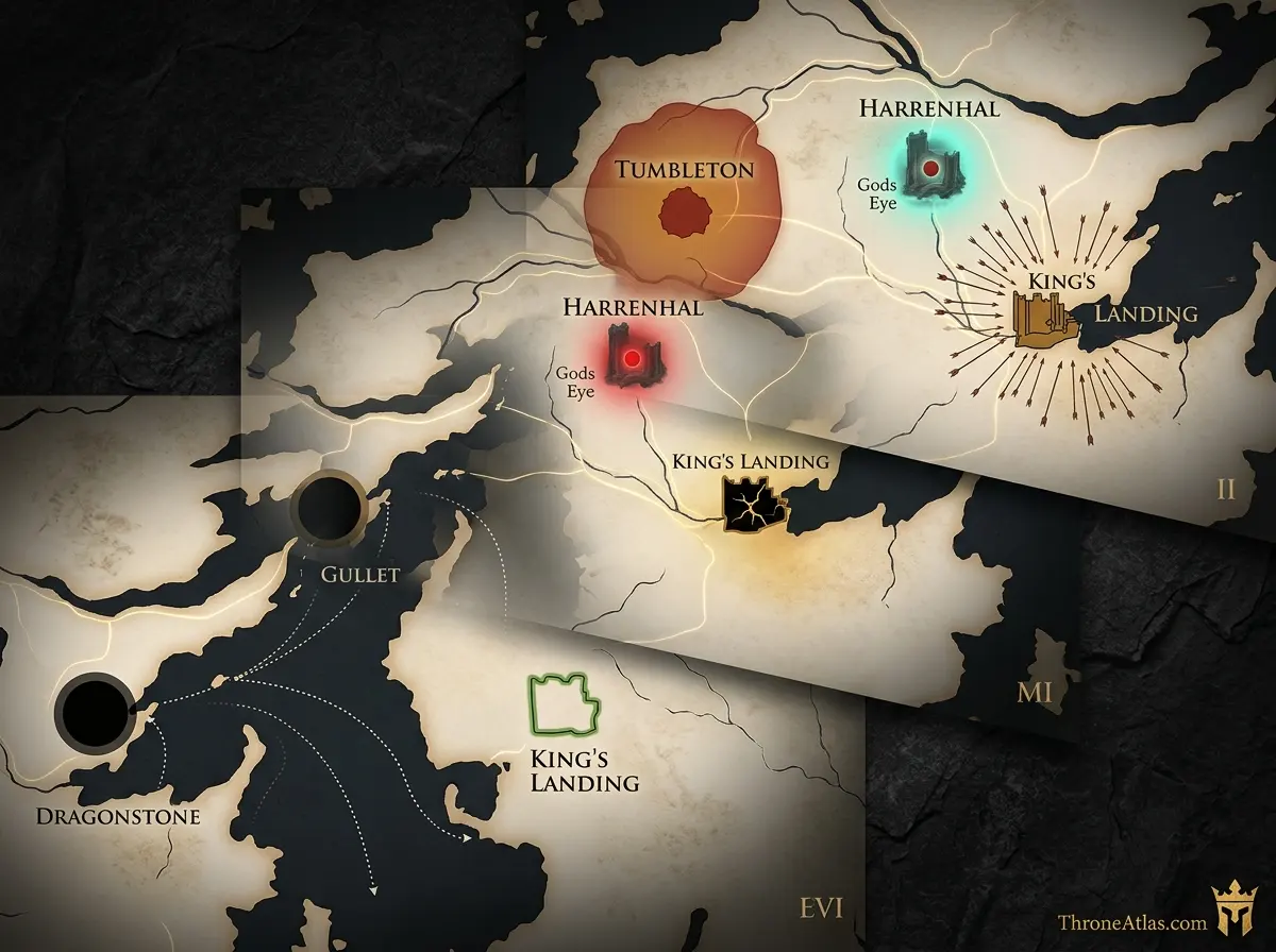
This visual map is the fast geographic reference for the guide below. It is designed to show the places, routes, borders, strongholds or battle zones that matter most to this topic before you move into the deeper lore and strategy.
In This Guide
- Visual Map at a Glance
- What the House of the Dragon Season 3 Map Actually Shows
- Dragonstone: The Black Council’s Starting Point
- The Battle of the Gullet: Why the Sea Lane Matters
- King’s Landing Changes Hands
- Harrenhal: The Riverlands Pivot
- Tumbleton and the Southern War
- How the Season 3 Control Map Changes
- Dragons as Geography: Range, Speed, and Risk
- Season 3 vs Fire & Blood: How to Read Adaptation Geography
- What the Season 3 Map Sets Up Next
House of the Dragon Season 3 Map: Every Major Location, Battle & Route: What Matters Most
Season status
Season 3 has fully aired; this page maps the completed 2026 season rather than speculating about future episodes.
Opening battlefield
The Gullet connects the Velaryon/Dragonstone sea network to Blackwater Bay and becomes the season’s first major military crisis.
Capital shift
King’s Landing changes political control early, proving that holding the Red Keep and controlling the wider realm are different problems.
Riverlands pivot
Harrenhal remains the inland hinge because roads, armies and dragon routes converge around the Gods Eye.
Southern front
Tumbleton pulls the Reach into the center of the war and gives the Hightower host a strategically meaningful staging point.
Dragon mobility
Dragons shrink travel time but every flight also leaves another location less protected.
Map method
Use time layers—early season, midseason and finale—because a single static faction map hides the season’s most important changes.
Canon note
The HBO adaptation and Fire & Blood share geography but not always the same route, timing or character placement.
Places to Plot on the Map
| Location | Region / Zone | Why It Matters | Map Reading |
|---|---|---|---|
| Dragonstone | Crownlands / Narrow Sea | Rhaenyra’s starting headquarters and dragon base | Island stronghold linked to King’s Landing by short aerial and sea routes |
| The Gullet | Narrow Sea approach | Opening sea battle; Velaryon and Triarchy power collide | Maritime chokepoint controlling access between Blackwater Bay, Driftmark and open sea |
| King’s Landing | Crownlands | Iron Throne, Red Keep and central political prize | Capital changes hands but remains dependent on roads, food and loyalty |
| Harrenhal | Riverlands | Aemond, Alys Rivers and the inland war | Central road/riverland pivot beside the Gods Eye |
| Tumbleton | The Reach | Hightower host and finale conflict zone | Southern staging point on routes toward the Crownlands |
| Oldtown / Hightower sphere | The Reach | Political and military rear base behind the Hightower advance | Explains why southern armies can be raised and supplied |
| Driftmark / Velaryon waters | Crownlands / Narrow Sea | Fleet identity and Gullet logistics | Sea-power node closely tied to Dragonstone |
| Gods Eye | Riverlands | Geographic anchor beside Harrenhal | Major inland landmark that helps orient central Westeros |
What the House of the Dragon Season 3 Map Actually Shows
The Season 3 map is a war map, not a sightseeing map: Dragonstone begins as Rhaenyra’s operational base, the Gullet becomes the season’s opening battlefield, King’s Landing changes hands, Harrenhal becomes the dangerous center of Aemond’s story, and Tumbleton becomes the decisive southern war zone by the finale.
Season 3 finally turns the Dance of the Dragons from a collection of threats into a moving geographic conflict. In the first two seasons, viewers could often think of the war as two courts facing one another across the Narrow Sea: the Blacks on Dragonstone, the Greens in King’s Landing. Season 3 breaks that simple picture. Fleets collide in the Gullet, dragons leave their home bases, the capital changes political hands, armies continue crawling through the Riverlands and the Reach, and characters who once seemed fixed to one castle become mobile pieces on a much wider board.
That movement is why a dedicated House of the Dragon Season 3 map is more useful than a generic Westeros map. The same castles are still there, but their meaning changes episode by episode. Dragonstone is no longer merely Rhaenyra’s refuge; it is the place from which she attempts to convert dragon superiority into political rule. King’s Landing is no longer simply “the Green capital”; it becomes a prize that can be taken without destroying the city, then a burden that must actually be governed. Harrenhal is not just Daemon’s haunted headquarters from Season 2; it becomes the place where Aemond’s isolation, Alys Rivers, and the Riverlands war knot together.
The map also clarifies a recurring lesson in the Dance: controlling a throne is not the same as controlling a realm. A ruler can sit in the Red Keep while hostile armies hold roads, rival dragons remain alive, ports become uncertain, and the food-producing south is still contested. Season 3 repeatedly makes that distinction visible. The war is won and lost through connected spaces, not one chair.
Dragonstone: The Black Council’s Starting Point
Dragonstone remains Rhaenyra Targaryen’s principal stronghold at the start of Season 3, positioned east of King’s Landing at the mouth of Blackwater Bay. Its island geography protects the Black leadership but forces them to depend on ships, dragons, and secure sea lanes whenever they project power onto the mainland.
Dragonstone is one of the most strategically elegant locations in the entire Targaryen story. It is close enough to the capital to threaten it, far enough offshore to resist an ordinary land assault, and tied to the Narrow Sea routes that connect Westeros with Essos. That combination explains why it works as the Blacks’ headquarters. Rhaenyra can gather dragonriders, hold councils, receive intelligence, and prepare an attack on King’s Landing without exposing the heart of her faction to a marching army.
But island strength creates island dependence. Food, men, messages, and ships have to move across water. The Velaryon fleet matters because Dragonstone without control of the surrounding sea is a fortress that can be isolated. Season 3 makes this vulnerability immediate when the Triarchy strikes the Gullet. The attack is not happening in some remote sea unrelated to the court; it is happening in the maritime system that makes Rhaenyra’s entire war position possible.
For map readers, Dragonstone should therefore be plotted as more than a castle marker. Draw lines west toward King’s Landing, southwest into Blackwater Bay, and east/southeast into the Gullet and Narrow Sea. Those lines are the arteries of Black power. When one is cut, Rhaenyra’s ability to move people and supplies changes. When the route to King’s Landing opens, the political map changes almost overnight.
The Battle of the Gullet: Why the Sea Lane Matters
The Gullet is the narrow maritime approach connecting Blackwater Bay with the broader Narrow Sea around Dragonstone and Driftmark. In Season 3 it becomes the opening major battlefield, where the Triarchy challenges Velaryon sea power and the Blacks pay an enormous human cost even while preventing a simple strategic collapse.
The phrase “Battle of the Gullet” can sound abstract until you place it on the map. The Gullet sits exactly where a hostile fleet would want to strike if the goal were to disrupt traffic between Dragonstone, Driftmark, Blackwater Bay, and the shipping lanes beyond. A force operating there does not need to capture every island or castle. It can damage ships, interrupt blockades, threaten supply, and force dragonriders to respond on terms chosen by the attacker.
Season 3’s opening battle turns that geography into spectacle, but the strategic logic is older than the episode. House Velaryon’s power has always been maritime. Corlys’s wealth, Driftmark’s identity, and the Blacks’ ability to pressure King’s Landing all depend on ships. The Triarchy’s involvement therefore targets a real system rather than a random fleet. The battle also shows the limits of dragon power over a chaotic sea engagement. Dragons dominate open ground, but ships, rigging, missiles, smoke, waves, and scattered combat create hazards that a simple “largest dragon wins” reading cannot explain.
After the battle, the map should be read with a scar across the water. Even when the Blacks retain the ability to continue the war, their fleet is disrupted and their leadership is emotionally transformed by loss. That makes the Gullet both a geographic chokepoint and a narrative hinge: the season moves from a sea crisis into an assault on the capital.
King’s Landing Changes Hands
King’s Landing falls to Rhaenyra early in Season 3 after Aemond leaves and the city’s defenses fracture. The important map point is that the capital can change political control without being physically moved or destroyed: the Red Keep, city gates, Blackwater waterfront, and roads remain the same while allegiance inside them changes.
King’s Landing sits on the west side of Blackwater Bay, south of the Crownlands’ central roads and within quick dragon range of Dragonstone. That proximity has always made the city vulnerable to Targaryen civil war. Season 3 exploits the vulnerability directly. When the city is deprived of its strongest immediate dragon defense, Rhaenyra can turn distance into speed: a short aerial crossing accomplishes what a conventional army might need weeks to achieve.
The takeover also demonstrates the difference between fortification and loyalty. Walls matter only if the people guarding them intend to resist. The Red Keep can be formidable, the city can possess scorpions and gates, and yet an internal political decision can neutralize much of that advantage. On a control map, King’s Landing changes color quickly. On a logistics map, however, nothing is solved. Hundreds of thousands of people still need food. Roads still lead toward hostile or uncertain territory. The city still depends on the Blackwater and the Reach. And rival claimants can still undermine the legitimacy of whoever occupies the throne.
This is the season’s sharpest geographic irony: Rhaenyra reaches the place she has wanted for years, but holding it places her at the center of every pressure line in Westeros. Dragonstone had protected her from those lines. The capital receives them all.
Harrenhal: The Riverlands Pivot
Harrenhal remains the central inland pivot of the Dance because it sits beside the Gods Eye in the Riverlands, close to major roads and within reach of armies moving between north, west, east, and south. Season 3 turns it into Aemond’s unstable base and keeps the Riverlands at the center of the war.
No castle in the Dance has more map importance relative to how cursed and impractical it feels on screen. Harrenhal is enormous, damaged, expensive, and psychologically oppressive, yet armies keep coming back to it because the location is too useful to ignore. From the Gods Eye area, a commander can influence routes toward King’s Landing, the western Riverlands, the Trident, and the approaches used by armies coming from the south.
Aemond’s arrival in Season 3 therefore has strategic logic beneath the personal drama. If he cannot simply defend the capital forever, Harrenhal offers a place from which to threaten the Black coalition and reassert control over the Riverlands. But the castle’s symbolic history matters too. Aegon the Conqueror proved at Harrenhal that massive walls are meaningless against overwhelming dragonfire. Generations later, the Dance repeatedly returns dragons to the same landscape, as if the war cannot escape the lesson.
The season then complicates the location with Alys Rivers, missing or shifting dragon power, and Aemond’s increasingly isolated position. On a map, Harrenhal is central. In human terms, that centrality can become a trap: enemies can approach from several directions, allies are far away, and control of the castle does not automatically produce control of the Riverlands families surrounding it.
Tumbleton and the Southern War
Tumbleton sits in the Reach on the road network linking the Hightower/Oldtown sphere with the routes toward King’s Landing. Season 3 makes it a major military concentration point, so the war’s center of gravity shifts south from the Riverlands toward the food-rich Reach by the finale.
Tumbleton is easy to overlook on a broad Westeros map because it does not have the visual fame of Oldtown, Highgarden, or King’s Landing. Strategically, that is exactly why the location is worth studying. It lies in a region rich enough to sustain large armies and on routes that matter to forces advancing from the southwest toward the Crownlands. When the Hightower host arrives, the town stops being background geography and becomes a pressure point.
The presence of a huge army transforms the map around it. Soldiers need quarters, grain, animals, water, road space, smiths, messengers, and defensible positions. A town occupied by thousands is not simply “controlled”; it is consumed by the logistics of war. Season 3 shows that pressure at ground level. For the audience, it also introduces the Reach as a lived battlefield rather than an abstract source of Hightower power.
By the finale, Tumbleton concentrates several threads that have been moving separately: Hightower military strength, Daeron’s emergence, dragonrider loyalties, forces sent by Rhaenyra, and the looming possibility of more dragons entering the same battlespace. The map is warning us that the Dance is no longer a two-capital conflict. The south can now decide what happens in the center.
How the Season 3 Control Map Changes
The cleanest way to read Season 3 is as a sequence of control shifts rather than a static map: the Blacks remain rooted at Dragonstone, seize King’s Landing, the Greens and their surviving claimants disperse, Harrenhal becomes contested in a different way, and Tumbleton grows into a major Green-aligned military zone before the finale complicates every alliance.
Static maps are good at answering “where?” but civil-war maps need to answer “when?” A castle can be in the same place while its political meaning changes three times. Season 3 is full of this problem. King’s Landing is the clearest example, but Harrenhal and the roads around Tumbleton matter for the same reason. If you color a map only once, you miss the story.
A useful ThroneAtlas reading is to imagine four layers. The first is formal control: who claims the castle or city. The second is military reach: which armies and dragons can actually respond nearby. The third is supply: who can keep those forces fed and equipped. The fourth is loyalty: which local lords, guards, dragonriders, or smallfolk will still cooperate tomorrow. Season 3 repeatedly separates those layers.
Rhaenyra’s occupation of King’s Landing looks decisive on the first layer. The survival and return of rival power complicate the second and fourth. The Hightower host at Tumbleton strengthens the Greens’ southern military reach even when they do not sit the throne. The season’s ending therefore leaves a map that is more fragmented than the one it began with, despite one side having captured the capital.
Dragons as Geography: Range, Speed, and Risk
Dragons collapse travel time but do not erase geography. Season 3 shows that riders can cross between Dragonstone, King’s Landing, Harrenhal, the Gullet, and southern battle zones far faster than armies, yet dragons still depend on rider decisions, visibility, vulnerability, resting places, and the political consequences of where they appear.
One reason the Dance feels different from the War of the Five Kings is that dragons create a second transportation system above the roads. An army may need days or weeks to march across a region, while a rider can cross enormous distances in a fraction of that time. That allows sudden strikes, rapid messages by direct presence, and dramatic changes in local morale. It also makes traditional castles less reliable as safe spaces.
But a dragon is not a teleportation spell. Riders get tired. Injured dragons disappear or recover away from obvious bases. Weather and visibility matter. Sea battles create different dangers from open-field attacks. A rider who leaves the capital to attack Harrenhal is also leaving the capital. Every movement creates an absence somewhere else. Season 3 repeatedly builds plot from that simple fact.
For mapping, the best approach is to draw dragon routes as arcs rather than territorial blocks. Vhagar’s location changes what the Greens can deter. Syrax and Caraxes make Rhaenyra and Daemon mobile, but using them somewhere commits them to that somewhere. Sunfyre’s return changes the political map because a living dragon restores more than firepower; it restores a claimant’s ability to appear, threaten, and be seen.
Season 3 vs Fire & Blood: How to Read Adaptation Geography
ThroneAtlas treats the HBO series and Fire & Blood as related but distinct map layers. The broad geography—Dragonstone, the Gullet, King’s Landing, Harrenhal, Tumbleton, Oldtown and the Reach—comes from Martin’s world, while the timing, character routes, survival, meetings, and exact sequence of control changes may differ in the television adaptation.
This distinction matters because map pages can accidentally turn adaptation choices into “book canon” or vice versa. Fire & Blood is written as an in-world history assembled from conflicting testimony. HBO’s series dramatizes one version of events and sometimes changes who is present, how a character reaches a location, which relationships drive a decision, or when a battle occurs. Both can be mapped, but they should not be blended without labels.
Season 3 makes that especially important because several of its most memorable movements depend on television-specific decisions. A map intended for viewers should follow what the episode actually shows. A lore sidebar can then explain how the book frames the same event or why a future location matters in the source chronology. That keeps the page useful for both audiences without pretending the two versions are identical.
The safest rule is simple: if the question is “where does this happen in Season 3?”, use the screen geography first. If the question is “where does this event sit in the Dance of the Dragons as written by Martin?”, use the historical geography of Fire & Blood and flag differences. ThroneAtlas can serve both intents on one page by keeping those layers explicit.
What the Season 3 Map Sets Up Next
By the end of Season 3, the map points toward a final phase in which possession of King’s Landing is no longer enough. The unresolved power around Harrenhal, the Reach and Tumbleton, surviving dragons and claimants, and the political cost of Rhaenyra’s rule all make the next conflict geographically wider rather than narrower.
The instinct after a capital falls is to assume the war is nearly finished. Season 3 teaches the opposite. A civil war built around dynastic legitimacy can survive the loss of a capital if a rival claimant, armies, dragons, and regional allies survive elsewhere. Westeros is too large and too politically layered for one city to settle the question by itself.
The southern map is especially important. The Reach is not just scenic farmland; it is the realm’s deepest reservoir of grain, manpower, wealthy houses, and roads feeding the capital. Oldtown adds religious, intellectual, and Hightower influence. Tumbleton sits in the path between that power base and the center. Whoever ignores the Reach risks holding the Iron Throne while losing the resources needed to keep it.
Harrenhal remains the other warning light. The Gods Eye and the Riverlands have repeatedly pulled major Targaryen characters into confrontation, and the castle’s position keeps it relevant even when the story moves south. The final-season map therefore has at least three major centers—King’s Landing, the Riverlands/Harrenhal zone, and the Reach/Tumbleton zone—plus the island and maritime network around Dragonstone. That is the board on which the endgame has to be played.
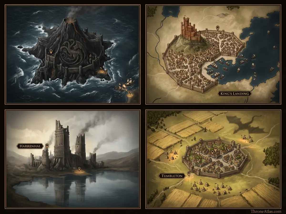
Key Season 3 Locations and Battle Zones
Continue Exploring ThroneAtlas
House of the Dragon Season 3 Map: Every Major Location, Battle & Route: FAQs
Where does House of the Dragon Season 3 take place?
Season 3 is spread across Dragonstone and its surrounding waters, the Gullet, King’s Landing, Harrenhal and the Riverlands, and the Reach around Tumbleton. The story is geographically wider than Season 2 because armies and dragonriders are moving rather than remaining concentrated at two rival courts.
What is the most important location in Season 3?
King’s Landing is the most politically important location because it contains the Iron Throne, but the Gullet, Harrenhal and Tumbleton are just as important militarily. The season repeatedly shows that possessing the capital does not automatically mean controlling fleets, field armies, dragons or regional loyalties.
Where is the Gullet on the map?
The Gullet is the narrow sea approach between the waters around Dragonstone and Driftmark and the entrance to Blackwater Bay. It is strategically important because ships moving between the Narrow Sea and the capital’s maritime approaches can be threatened there.
Why is Harrenhal important in Season 3?
Harrenhal sits in the central Riverlands beside the Gods Eye and near routes connecting several parts of Westeros. Its location makes it useful for influencing armies moving through the center of the continent, even though the castle itself is damaged, enormous and difficult to maintain.
Where is Tumbleton?
Tumbleton is a town in the Reach, south and west of King’s Landing within the fertile southern heartland. Its position on the broader route network between Hightower-controlled power in the southwest and the Crownlands makes it a logical concentration point for a major army.
Does Rhaenyra control King’s Landing in Season 3?
Yes, Rhaenyra takes King’s Landing during Season 3. The map-level lesson is that taking the capital changes formal control but does not end the war, because rival Targaryens, dragons, armies and regional alliances remain active elsewhere.
Is the Season 3 map the same as Fire & Blood?
The physical locations are drawn from the same world, but the television adaptation changes some timing, routes, meetings and character placements. ThroneAtlas treats HBO Season 3 as its own screen-canon layer and uses Fire & Blood as a separate historical comparison.
What map should I view before this one?
Start with the House of the Dragon Season 2 map and the broader Dance of the Dragons map. They explain the positions of Dragonstone, King’s Landing, Harrenhal, the Riverlands and the Velaryon fleet before Season 3 begins.
What does the Season 3 finale change geographically?
The finale makes the Reach and Tumbleton far more important while keeping King’s Landing and Harrenhal unresolved strategic centers. Surviving dragons and rival claimants mean the war remains multi-centered rather than collapsing into a single final battlefield.
Will this page be updated for Season 4?
This page is designed to remain a Season 3 reference. ThroneAtlas should connect it to a separate Season 4 map so search intent, spoilers, episode geography and internal links stay clean rather than turning one URL into a mixed multi-season page.
The Geography Behind the Story
The House of the Dragon Season 3 map is centered on six strategic zones: Dragonstone, the Gullet, King’s Landing, Harrenhal and the Gods Eye, the Reach/Tumbleton corridor, and the roads and sea lanes connecting them. The season begins with the Battle of the Gullet, quickly shifts political control of King’s Landing, and ends with the war’s center of gravity moving toward Tumbleton while surviving dragons and rival claimants keep the realm divided. The deeper value of this page is not memorizing names. It is seeing how roads, rivers, coasts, castles, distance, food, dragons, armies, and old political borders determine what characters can realistically do next. That is the layer ThroneAtlas is built to make visible.