Riverlands Map: Riverrun, Harrenhal, the Trident, Houses & Battles
A complete geography-of-war guide to Westeros’s central river country—where forks, bridges, fertile land and open borders turn local castles into strategic prizes in almost every major conflict.
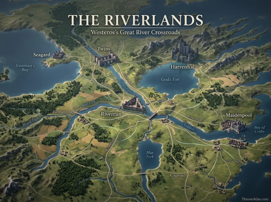
The Riverlands occupy central Westeros around the Trident river system. Riverrun is the Tully seat, Harrenhal dominates the Gods Eye corridor, and the Twins control a critical Green Fork crossing. The region’s central position, fertile countryside and lack of a single strong natural frontier make it commercially connected but exceptionally vulnerable to armies, which is why so many wars in Game of Thrones and House of the Dragon are fought across riverlord land.
Riverlands Map at a Glance
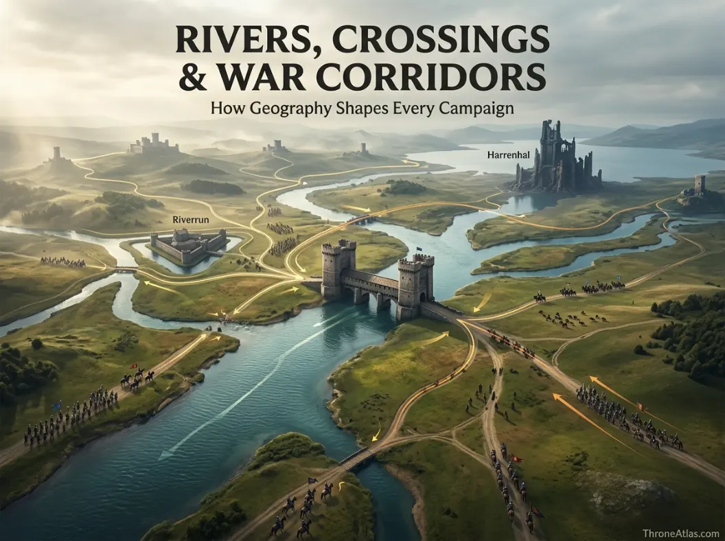
This visual map is the fast geographic reference for the guide below. It is designed to show the places, routes, borders, strongholds or battle zones that matter most to this topic before you move into the deeper lore and strategy.
In This Guide
- Visual Map at a Glance
- What the Riverlands Map Actually Shows
- The Trident: Three Forks That Organize the Region
- Riverrun: A Castle Built Around Water
- Harrenhal and the Gods Eye: Central Power Without Security
- The Twins: One Crossing, Enormous Political Leverage
- Seagard, Maidenpool and Saltpans: The Riverlands Face the Sea
- Blackwood and Bracken Country: Local Rivalry on a National Battlefield
- Why the Riverlands Suffer in Nearly Every Major War
- Riverlands in the Dance of the Dragons
- How to Read a Riverlands Campaign Map
Riverlands Map: Riverrun, Harrenhal, the Trident, Houses & Battles: What Matters Most
River system
Red, Blue and Green Forks of the Trident organize movement.
Regional seat
Riverrun, ruled by House Tully in the post-Conquest order.
Central hinge
Harrenhal and the Gods Eye sit on major inland routes.
Critical crossing
The Twins turn House Frey’s bridge into political leverage.
Historic vulnerability
The region has repeatedly been invaded or ruled by outside powers.
Local rivalries
Blackwood and Bracken tensions survive across multiple national wars.
Economic cost
Productive farmland attracts armies that need food and forage.
Map method
Plot rivers and crossings before faction arrows to understand campaigns correctly.
Places to Plot on the Map
| Location | Region / Zone | Why It Matters | Map Reading |
|---|---|---|---|
| Riverrun | Western-central Riverlands | House Tully seat at river confluence. | Regional political center |
| Harrenhal | Gods Eye | Huge castle on central roads. | Campaign hinge |
| The Twins | Green Fork | House Frey fortified crossing. | Route-control node |
| Trident | Region-wide | Three-fork river network. | Movement skeleton |
| Seagard | West coast | House Mallister seat facing Ironborn threats. | Coastal defense |
| Maidenpool | East | Town linking river country toward Bay of Crabs. | Trade / eastern route |
| Saltpans | East | Smaller settlement heavily affected by war. | Civilian war geography |
| Gods Eye | Central-east | Large inland lake beside Harrenhal. | Ancient + strategic landscape |
What the Riverlands Map Actually Shows
The Riverlands map shows the central lowland crossroads of Westeros, dominated by the Trident and its Red, Blue and Green Forks. Riverrun, Harrenhal, the Twins, Seagard, Maidenpool, Saltpans and the Gods Eye sit inside a region whose open borders and road network make it commercially connected but repeatedly vulnerable to armies marching between stronger neighboring realms.
The Riverlands are where Westerosi geography stops being background and starts behaving like a trap. There is no giant southern desert, mountain wall or northern swamp protecting the whole region. Rivers offer local defensive advantages, but the broader territory lies between the North, Vale, Crownlands, Westerlands and Reach-facing routes. When major powers fight, armies repeatedly find reasons to cross riverlord land.
That centrality explains the region’s political history. Before Aegon’s Conquest, Riverlands communities had endured rule and pressure from neighboring kingdoms, including Ironborn House Hoare. Under the Targaryens, House Tully becomes the leading regional dynasty from Riverrun, but it governs a collection of old houses with deep rivalries and strong local identities rather than a naturally isolated kingdom.
A detailed map therefore needs rivers first and faction colors second. Crossings decide where forces can move. The Twins can make House Frey strategically valuable. Riverrun’s waterways strengthen its defense. Harrenhal dominates routes near the Gods Eye despite its cursed reputation. The Trident becomes a battle corridor because three great river branches organize movement across the region.
The Trident: Three Forks That Organize the Region
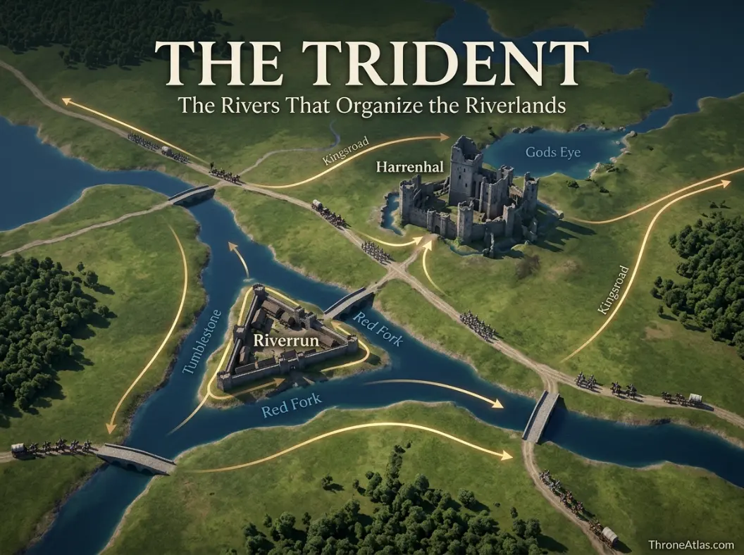
The Trident is the defining river system of the Riverlands. Its Red, Blue and Green Forks divide and reconnect large parts of the region, shaping roads, bridge sites, fertile land and military movement. Armies cannot treat the rivers as decorative lines; they have to find crossings, secure banks and protect supply routes.
River crossings create predictable friction. A large force cannot simply step over deep water. Bridges can be held, ferries are limited, and fords depend on local knowledge and conditions. This gives defenders opportunities even in a region without mountain walls. A commander who controls the correct crossing can delay an enemy far larger than the garrison itself.
The three Forks also make the Riverlands feel fragmented from within. A lord on one branch may have better access to a neighboring kingdom than to another riverlord’s seat. That helps explain why political unity can be difficult. House Tully’s authority has to work through alliances among houses whose local geographies create different priorities.
For readers tracking the War of the Five Kings, the Trident should be treated as the map’s skeleton. Battles at the Green Fork, Whispering Wood and the Camps become clearer when placed against river routes and the western approach from the Westerlands. Geography reveals why Robb Stark can divide forces, threaten crossings and maneuver around larger enemies.
Riverrun: A Castle Built Around Water
Riverrun, seat of House Tully, stands where the Tumblestone meets the Red Fork, using water as a defensive system. Its location makes it a strong regional seat and a natural command point for western Riverlands politics, especially when Lannister forces enter from the Westerlands.
Riverrun demonstrates how a castle can convert local geography into fortification. Rivers protect multiple sides and can be manipulated to strengthen the defensive perimeter. Instead of simply building higher walls on open ground, the Tully seat makes attackers solve a water problem before they can solve a siege problem.
The location also explains why Riverrun becomes central during the War of the Five Kings. Lannister pressure comes from the west, while Stark relief arrives from the north. The castle sits close enough to that contest to become both a military objective and a political meeting point between House Stark and House Tully.
Yet Riverrun does not dominate the entire region in the way Winterfell symbolizes the North. Harrenhal, the Twins and powerful river houses can each become strategically decisive. That dispersed importance is part of Riverlands identity: House Tully leads, but the map contains multiple nodes capable of changing a war.
Harrenhal and the Gods Eye: Central Power Without Security
Harrenhal lies beside the Gods Eye near the eastern-central Riverlands and commands an exceptionally useful position on roads connecting multiple regions. Its immense scale gives it military and symbolic value, but its history shows that size does not guarantee safety—especially in a world with dragons and constantly shifting claimants.
Harren the Black built the castle to make his rule over the Isles and Rivers look permanent. Aegon and Balerion turned that statement into a ruinous lesson. After the Conquest, Harrenhal remains too strategically located to ignore, so house after house occupies or inherits it despite its reputation for misfortune.
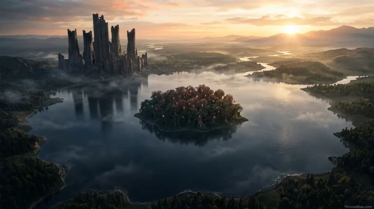
The Gods Eye adds another layer. The large inland lake and Isle of Faces give the area ancient religious and mythic associations, while roads around it make the zone practically important to armies. During the Dance of the Dragons, Harrenhal becomes a major operational center because controlling the central Riverlands affects movement toward King’s Landing, the Vale-facing east and the southern routes.
That is why ThroneAtlas treats Harrenhal as more than a haunted castle icon. It is a geographic hinge. Whoever holds it can influence a remarkable amount of surrounding movement, even if holding it safely is another question.
The Twins: One Crossing, Enormous Political Leverage
The Twins sit on opposite banks of the Green Fork and are connected by a fortified bridge controlled by House Frey. Their importance comes from scarcity: when an army needs that crossing, a family that might otherwise rank below the greatest river houses can demand terms far beyond the size of its lands.
This is one of the purest examples of location creating political power in the series. The Freys do not need to own the largest gold mines or the greatest city. They own a bridge an army may urgently need. Geography turns infrastructure into negotiation.
Robb Stark’s southward campaign makes the principle explicit. Crossing the Green Fork efficiently requires an agreement with Walder Frey, and that agreement creates personal and dynastic obligations that later become catastrophic when broken. The Red Wedding is remembered as betrayal, but the chain begins with map logic: the Starks need to get across a river.
On a regional map, the Twins should therefore be drawn as a route-control node rather than just two castle symbols. Its power exists because roads converge on a crossing that cannot be casually replaced. The same lesson appears throughout military history: bridges can be political institutions.
Seagard, Maidenpool and Saltpans: The Riverlands Face the Sea
Although the Riverlands are defined by inland waterways, their eastern and western edges connect to maritime and coastal threats. Seagard historically watches the western coast and Ironborn danger, while Maidenpool and Saltpans connect eastern river country toward the Bay of Crabs and Narrow Sea-facing trade.
These locations complicate the idea that the Riverlands are purely an inland battlefield. Water flows outward. Rivers and coastal access create trade but also expose settlements to raiding, naval movement and refugees. A war can move along water networks as well as across roads.
Seagard’s history is particularly tied to defense against Ironborn attacks. That gives House Mallister a strategic culture different from a lord whose main concern is a Lannister army crossing the western border. Maidenpool, by contrast, faces eastward economic and military connections. Saltpans becomes a vivid example of what war does to smaller communities when central protection collapses.
A regional atlas should preserve these different orientations. The Riverlands are not one homogeneous plain. Houses at its edges look outward toward different threats, helping explain why local loyalties and military priorities vary.
Blackwood and Bracken Country: Local Rivalry on a National Battlefield
The ancient rivalry between Houses Blackwood and Bracken shows how local geography and inherited memory can survive through every change of king. Their neighboring lands place old hostility inside the heart of a region repeatedly used by national armies, so realm-wide wars often reactivate disputes that already existed.
Westeros is full of feuds, but the Blackwood-Bracken conflict is unusually persistent. It reminds map readers not to assume that faction colors erase local history. Two houses can nominally serve the same regional lord or even the same crown while carrying grievances older than the current war.
In the Dance of the Dragons, their opposition becomes part of the wider Black and Green struggle. In later periods, the rivalry still shapes politics. Geography helps sustain it because neighboring power centers compete over land, status and memory. A distant royal decree cannot make adjacency disappear.
This is an important AI-era content point as well: answering “who controls the Riverlands?” with one house name is too shallow. Formal hierarchy matters, but so do subregional relationships. ThroneAtlas maps both the lord-paramount layer and the local-house layer because that is how the story actually works.
Why the Riverlands Suffer in Nearly Every Major War
The Riverlands suffer repeatedly because they combine central location, productive farmland and weak natural perimeter defenses. Armies entering from the west, north, south or east can find routes through the region, while foraging and occupation turn civilian agricultural wealth into a military resource.
An army has to eat. That simple fact makes fertile countryside dangerous to own during war. Invaders can seize grain, livestock and shelter, while defenders may burn supplies to deny them. Villages become targets even when they have no strategic castle because food itself is strategic.
The Riverlands also contain crossroads connecting major political centers. A Lannister army moving east, a Stark army moving south, a Targaryen force moving between Harrenhal and King’s Landing, or a host approaching the Twins can all pass through riverlord territory for different reasons. The region becomes the board on which other kingdoms fight.
This helps explain the emotional tone of Arya’s Riverlands journey in Game of Thrones. Away from command tents, she sees burned farms, refugees and armed men whose banners change faster than civilian suffering. The map and the human story are the same system viewed at different scales.
Riverlands in the Dance of the Dragons
During the Dance, the Riverlands become one of the war’s decisive theaters because Harrenhal, the Gods Eye, Tumbleton-facing roads and rival river houses place dragons and armies in a dense central network. Control changes repeatedly, making the region impossible to summarize with one static faction color.
House of the Dragon viewers can easily focus on Dragonstone and King’s Landing because the rival courts begin there. The Riverlands gradually prove that the war’s center is mobile. Daemon’s occupation of Harrenhal, the struggle for riverlord support and later battles draw the conflict inland.
Dragons intensify rather than erase the geographic value of the region. A rider can move quickly, but armies still need roads and supplies, while castles remain rallying points. Harrenhal’s central location allows dragon power and conventional campaigning to overlap.
The Riverlands are therefore an ideal cluster for ThroneAtlas: Harrenhal, the Gods Eye, House Blackwood, House Bracken and multiple battle maps all become more understandable when linked back to the regional geography.
How to Read a Riverlands Campaign Map
A Riverlands campaign map should prioritize river forks, crossings, road junctions and changing control rather than simply coloring the whole region for one faction. The best questions are where an army can cross, what it can feed on, which castle secures a route, and which neighboring house might interrupt movement.
This is why regional campaign pages benefit from time layers. At one moment a road is open; later a castle falls or a bridge alliance changes and the same route becomes dangerous. A static political map can imply certainty where commanders actually face contingency.
The practical method is to begin with the Trident, add major castles, add western and eastern approaches, then place army arrows. Only after that should faction colors be added. This keeps physical geography from disappearing beneath heraldry.
Readers can then understand battles as solutions to map problems. The Green Fork is not randomly named scenery. The Whispering Wood is not merely a dramatic ambush backdrop. The Twins are not famous because of architecture. Each location matters because terrain and movement create an opportunity someone exploits.
Rivers, Crossings and War Corridors
Continue Exploring ThroneAtlas
Riverlands Map: Riverrun, Harrenhal, the Trident, Houses & Battles: FAQs
Where are the Riverlands in Westeros?
The Riverlands sit near the center of Westeros around the Trident, between several major regions including the North, Vale, Crownlands and Westerlands. That central location is a major reason armies repeatedly cross them.
Who rules the Riverlands?
House Tully of Riverrun becomes the leading regional house after Aegon’s Conquest. Before that, the Riverlands were not an independent Tully kingdom at the moment of conquest; they were ruled with the Iron Islands by House Hoare.
What are the three rivers of the Trident?
The Trident is formed by the Red Fork, Blue Fork and Green Fork. These branches shape roads, bridges, fords and military routes across the region.
Why is Harrenhal important?
Harrenhal is enormous and centrally located beside the Gods Eye. Although its history is famously disastrous for owners, its position makes it valuable to armies and rulers moving through the Riverlands.
Why are the Twins strategically important?
House Frey controls a fortified bridge across the Green Fork. When an army needs that crossing, access becomes a bargaining chip, allowing the Freys to demand political concessions disproportionate to the size of their territory.
Why are so many battles fought in the Riverlands?
The region is centrally located, fertile and comparatively open to movement from multiple directions. Armies can find roads and food there, while the absence of a mountain or desert perimeter makes broad invasion harder to prevent.
Are the Riverlands part of the North?
No. They are a separate region. Political alliances often connect Houses Tully and Stark, and northern armies campaign there, but the Riverlands have their own houses, geography and regional leadership.
Where is the Gods Eye?
The Gods Eye is a large lake in the eastern-central Riverlands with Harrenhal on its shore and the Isle of Faces within it. It combines strategic location with some of the oldest religious and legendary associations in Westeros.
What houses are important in the Riverlands?
Important houses include Tully, Frey, Blackwood, Bracken, Mallister, Mooton and historically Whent, along with many others. Their local rivalries and crossings make the region politically more complex than a single Tully color suggests.
Why is the Riverlands map important for House of the Dragon?
The Dance of the Dragons moves heavily through Harrenhal and riverlord country. Daemon’s campaigns, Blackwood-Bracken conflict and later dragon events make the Riverlands one of the central theaters beyond King’s Landing and Dragonstone.
The Geography Behind the Story
The Riverlands occupy central Westeros around the Trident river system. Riverrun is the Tully seat, Harrenhal dominates the Gods Eye corridor, and the Twins control a critical Green Fork crossing. The region’s central position, fertile countryside and lack of a single strong natural frontier make it commercially connected but exceptionally vulnerable to armies, which is why so many wars in Game of Thrones and House of the Dragon are fought across riverlord land. The deeper value of this page is not memorizing names. It is seeing how roads, rivers, coasts, castles, distance, food, dragons, armies, and old political borders determine what characters can realistically do next. That is the layer ThroneAtlas is built to make visible.