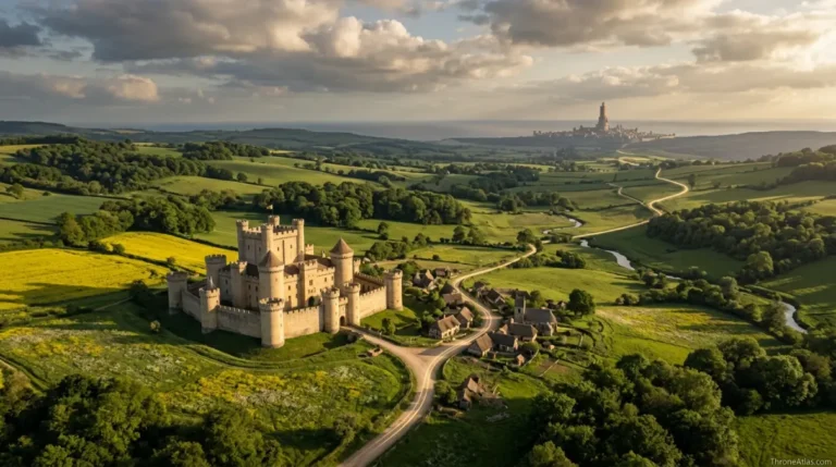
The North Map: Winterfell, Houses, Castles, Roads & Regions
A map-first guide to Westeros’s vast northern kingdom—its castles, bannermen, ports, forests, defensive choke points, roads and the distances that make northern politics unlike anywhere else.
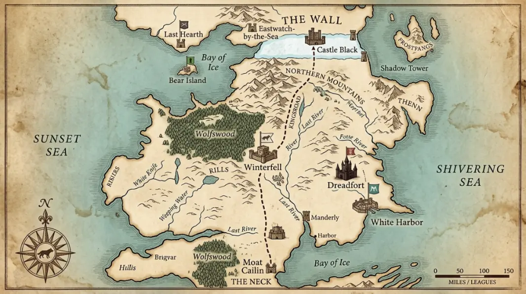
The North is Westeros’s largest region, extending from the Neck and Moat Cailin to the Wall. Winterfell is its political center, White Harbor its major port, and the kingsroad its main north-south artery. Its strategic character comes from enormous distances, sparse settlement, severe winters and the southern bottleneck at the Neck, which together make the region difficult both to invade and to govern from far away.
The North Map at a Glance
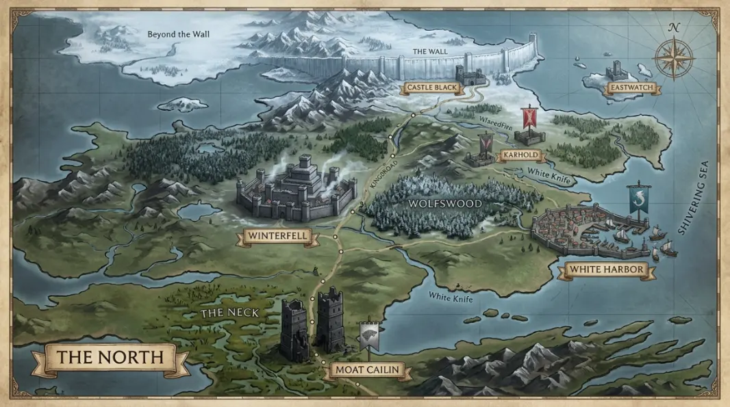
This visual map is the fast geographic reference for the guide below. It is designed to show the places, routes, borders, strongholds or battle zones that matter most to this topic before you move into the deeper lore and strategy.
In This Guide
- Visual Map at a Glance
- What the North Map Actually Shows
- The Neck and Moat Cailin: The North’s Southern Gate
- Winterfell: Political Center of a Region Too Large for One Castle
- White Harbor: The North’s Maritime Gate
- The Dreadfort and the Stark–Bolton Power Axis
- The Wall, Last Hearth and the Far North
- Western North: Bear Island, Wolfswood, Rills and Mountain Country
- Skagos and the Eastern Fringe
- Why Northern Distance Shapes Every War
- The North Across Game of Thrones and House of the Dragon
The North Map: Winterfell, Houses, Castles, Roads & Regions: What Matters Most
Political center
Winterfell, ancestral seat of House Stark.
Southern gate
The Neck and Moat Cailin constrain overland entry from the Riverlands.
Major port
White Harbor connects northern trade to the Narrow Sea.
Internal rival
The Dreadfort gives House Bolton an old independent power base.
Far north
Last Hearth, the Gift and the Wall face a different threat environment from southern houses.
Western outposts
Bear Island and remote coastal lands depend more heavily on local defense.
Road spine
The kingsroad connects Winterfell toward Castle Black and south toward the realm.
Core strategic fact
Distance protects the North but also makes supply, communication and rapid response difficult.
Places to Plot on the Map
| Location | Region / Zone | Why It Matters | Map Reading |
|---|---|---|---|
| Winterfell | Central North | House Stark seat and political gathering point. | Regional capital |
| Moat Cailin | The Neck | Controls principal southern land approach. | Defensive choke point |
| White Harbor | East coast | Manderly port, trade and naval access. | Maritime gateway |
| Dreadfort | Northeast | Traditional Bolton stronghold. | Internal power center |
| Last Hearth | Far North | House Umber seat close to the Wall. | Northern frontier lordship |
| Bear Island | Sunset Sea | House Mormont island seat. | Remote western defense |
| Skagos | Northeast islands | Remote northern island territory. | Peripheral / maritime |
| The Wall | Northern boundary | Night’s Watch jurisdiction and defensive barrier. | Separate sworn order |
| Kingsroad | North–south | Main overland route through region. | Travel and supply spine |
What the North Map Actually Shows
The North map shows the largest and most sparsely settled region of the Seven Kingdoms, stretching from the Neck and Moat Cailin to the Wall. Winterfell anchors its political center, while White Harbor, the Dreadfort, Last Hearth, Bear Island, the Wolfswood, the northern mountains, the Rills and the eastern coast explain how one kingdom can contain radically different strategic landscapes.
The North looks simple when viewed at continent scale: one enormous block under House Stark. Zoom in and that simplicity disappears. A rider can spend days crossing country that still belongs to the same lord paramount. Forest, bog, mountain, moor, coast and open cold country create different travel problems, and there are far fewer major cities to absorb travelers than in the southern kingdoms. That distance is not decoration; it is one of the reasons northern politics develops such a strong sense of local obligation.
Winterfell is the symbolic center because the Starks have ruled from it for thousands of years, first as kings and later as Wardens of the North. Yet controlling Winterfell does not automatically mean physically controlling every corner of the region. White Harbor has maritime wealth and southern-facing trade. The Boltons historically hold power in the northeast from the Dreadfort. House Mormont’s Bear Island sits off the western coast. House Umber occupies the far north near the Gift, while House Reed controls the difficult southern approach through the Neck.
A useful North map therefore has to show relationships, not only points. Which route reaches the Wall? Which houses can reinforce Winterfell? Which port connects northern politics to the Narrow Sea? Where can an invading southern army be slowed before it ever reaches open northern country? Those questions reveal the region as a system.
The Neck and Moat Cailin: The North’s Southern Gate
The Neck is the North’s great defensive filter. Its bogs, narrow causeways and difficult terrain make mass movement from the Riverlands into the North far harder than the map’s open border suggests, while Moat Cailin commands the principal overland approach and has repeatedly made southern invasion strategically unattractive.
If Winterfell is the heart of the North, the Neck is the locked door. Armies depend on roads, wagons, horses, dry ground and predictable movement. Marsh country attacks all of those assumptions. Large forces become constrained, scouts have difficulty reading unfamiliar terrain, and defenders can exploit narrow approaches. House Reed and the crannogmen add a human layer to those natural obstacles because they know a landscape outsiders find disorienting.
Moat Cailin magnifies the bottleneck. Its surviving towers may not look like the most glamorous fortress in Westeros, but location is often more important than architecture. A modest fortification placed across the only practical route can be more strategically valuable than a huge castle that an enemy can simply bypass. This is why the site matters in both ancient history and the War of the Five Kings.
The Neck also helps explain northern independence movements. A ruler in King’s Landing must project authority over an enormous region connected to the south through a difficult gateway. When central power weakens, distance and terrain make the North unusually capable of acting like the old kingdom it once was. Geography does not guarantee independence, but it lowers the cost of trying to defend it.
Winterfell: Political Center of a Region Too Large for One Castle
Winterfell is the seat of House Stark and the principal political center of the North, positioned far enough south to communicate with the rest of Westeros yet deep enough inside northern territory to function as a secure gathering place for bannermen. Its importance comes from dynastic continuity, roads and legitimacy as much as from walls.
On a map, Winterfell sits in a practical middle position between the Neck and the Wall. That makes it useful as a relay point for people traveling north or south on the kingsroad. It is not a coastal trade city like White Harbor, and it is not a border fort like Castle Black. Its power is administrative and symbolic. Northern houses understand Winterfell as the place where Stark authority is made visible.
The castle’s hot springs add another geographic detail that matters in a cold region. In the novels, heated water runs through walls and helps warm parts of the complex. Winterfell’s glass gardens also reflect the problem of sustaining life through unpredictable seasons. The North cannot assume short winters, so infrastructure that would seem luxurious elsewhere can become resilience.
When Winterfell changes hands during the story, the political map destabilizes because holding the castle carries symbolic weight. Yet occupiers still need the loyalty of northern houses and access to food and roads. This is a recurring ThroneAtlas rule: a seat of power is strongest when geography, legitimacy and networks align. A castle without the surrounding network is a prize under siege.
White Harbor: The North’s Maritime Gate
White Harbor is the North’s major port and largest urban center, ruled by House Manderly. Its position on the eastern coast gives the region access to Narrow Sea trade, southern shipping and maritime movement that bypasses the long overland route through the Neck.
White Harbor is strategically different from every other major northern seat because ships change distance. Goods that would take weeks by road can move along the coast, and a port creates contact with merchants who have no reason to ride to Winterfell. That makes House Manderly unusually wealthy and urban by northern standards.
The city also provides redundancy. If the kingsroad is dangerous or the Neck becomes politically blocked, the North is not completely cut off from the wider world. Armies still cannot be supplied effortlessly by sea, especially once they move inland, but access to ships gives northern rulers another strategic option. The port can receive grain, people, news and naval support from directions a land-only map would miss.
Culturally, White Harbor also represents historical layering. The Manderlys are not originally a northern family, yet they become deeply integrated into Stark political order. The map therefore challenges the idea that regions are culturally frozen. Geography provides a framework, but migration, exile and patronage can reshape who belongs there over centuries.
The Dreadfort and the Stark–Bolton Power Axis
The Dreadfort anchors House Bolton’s traditional power in the northeast and represents the North’s most persistent internal rival to Stark dominance. Its distance from Winterfell gives the Boltons a substantial local base, while the roads between the two seats become politically important whenever northern unity breaks down.
The Stark-Bolton relationship shows why a large kingdom cannot be understood only through its capital. House Stark may possess deeper legitimacy, but a major vassal with its own lands, men and fortress can become dangerous when the center is weak. The Dreadfort’s position allows House Bolton to govern a meaningful territory rather than existing as a household dependent on daily proximity to Winterfell.
Historically, the rivalry is older than the events of Game of Thrones. Bolton traditions preserve memories of a time when northern kings fought one another before Stark unification. That past matters because political identity can survive underneath formal loyalty. When Roose Bolton betrays Robb Stark, the act is shocking, but the map reminds us that House Bolton already possesses the geographic base needed to capitalize on betrayal.
After the Red Wedding, control of northern castles and roads becomes a legitimacy contest. A Bolton regime can occupy Winterfell, yet it still has to manage houses with old Stark loyalties. Again, the map distinguishes possession from durable rule.
The Wall, Last Hearth and the Far North
The northern edge of the region is defined by the Wall and by houses whose lands lie closest to it, including House Umber at Last Hearth. This geography gives far-northern lords a different threat environment from families near the Neck: wildling movement, the Gift, the Night’s Watch and ancient dangers are practical realities rather than distant stories.
Distance changes political priorities. A southern lord may think first about King’s Landing, taxes or rival houses. A lord near the Wall must also think about raiders, Watch strength, weather and what happens if the northern boundary fails. That helps explain why northerners can appear culturally separate even within their own region. The North is too large for every house to experience the same problems.
Last Hearth is a useful marker because it lies near the great defensive boundary without being part of the Night’s Watch. House Umber remains a feudal northern house, but its location puts it in direct contact with consequences from beyond the Wall. When the dead move south, this is no longer peripheral geography. It becomes the first line of human settlement in danger.
The Wall itself is administratively unusual. The Night’s Watch is sworn to neutrality rather than House Stark, and the Gift belongs to its support system. On a faction map, that means the North’s northern edge cannot simply be colored as ordinary Stark territory. Political and defensive jurisdictions overlap.
Western North: Bear Island, Wolfswood, Rills and Mountain Country
Western northern geography is fragmented by coast, forest, uplands and remote islands. Bear Island gives House Mormont a hardy maritime outpost, the Wolfswood forms one of Westeros’s great forests, and the Rills and northern mountain country create local travel patterns that differ sharply from the main kingsroad corridor.
This is the side of the North that a highway-style map can underrepresent. The kingsroad encourages readers to imagine north-south movement as the default, but many northern communities live away from that spine. Forest tracks, coastal routes and smaller roads matter more locally. In winter, those differences become even more important as weather narrows the set of practical paths.
Bear Island is geographically small compared with the mainland, yet its isolation contributes to a distinctive martial identity. A western island exposed to raiding cannot depend on a rapid response from Winterfell. Local defense has to be embedded in the community. That helps explain why House Mormont’s reputation feels larger than the territory itself.
The Wolfswood, meanwhile, complicates movement near Winterfell’s western approaches. Forest provides resources and cover but slows armies and reduces visibility. The North repeatedly rewards people who know local terrain better than invaders. That principle applies from the bogs of the Neck to wooded and mountainous country farther north.
Skagos and the Eastern Fringe
Skagos sits off the northeastern coast and is politically part of the North while remaining culturally and geographically remote from Winterfell. Its isolation, difficult reputation and position beyond ordinary travel routes make it a reminder that feudal maps often claim more uniform control than rulers can exercise in daily life.
Islands magnify cultural distance. Even when they owe formal allegiance, sea crossings create logistical friction that mainland lords do not face. News arrives differently, trade follows separate rhythms and outsiders may rely on rumor because few people visit. Skagos becomes mysterious partly because ordinary political traffic rarely passes through it.
For map-making, that means the island should not be treated as empty decorative space. Its remoteness is itself meaningful. It extends the North eastward into cold waters and demonstrates that “the North” includes communities beyond the main Winterfell-to-Wall corridor.
Skagos also warns against confusing narrative attention with geographic importance. The main television story spends little time there, but book readers encounter it as part of the larger northern world. An authority atlas should preserve those places because topical coverage becomes stronger when it reflects the world rather than only the most filmed locations.
Why Northern Distance Shapes Every War
The North’s decisive strategic characteristic is distance. It protects the region from easy occupation, but it also makes mobilization, supply and communication slow. Northern armies marching south leave their homeland far behind, while southern rulers trying to project power north must cross the Neck and maintain very long lines of support.
Robb Stark’s campaign demonstrates both sides of the problem. Once the northern host moves into the Riverlands, it can win battles and maneuver effectively, but it is operating far from Winterfell. Political shocks at home become difficult to correct. A successful field army is not the same thing as secure control of a homeland hundreds of miles away.
Later, Stannis Baratheon discovers the opposite challenge when campaigning in northern winter. Local alliances, food, weather and road knowledge matter as much as nominal force strength. The farther an army travels from a friendly base, the more geography becomes an opponent.
This is why the North map is best read as a logistics map. The castles are important, but the blank spaces between them may matter even more. An army has to cross those spaces. Ravens can carry messages faster than men, yet orders still need people capable of acting on them. In Westeros’s largest region, time and distance are political forces.
The North Across Game of Thrones and House of the Dragon
The physical North changes little between House of the Dragon and Game of Thrones, but the political context changes dramatically. In the Dance era, House Stark is a powerful but distant Targaryen vassal; in the later series, the collapse of southern royal order allows northern identity and the memory of kingship to re-emerge as a direct political claim.
This comparison shows how the same geography can support different stories. During the Dance of the Dragons, Cregan Stark’s location means northern support takes time to become fully relevant. Distance slows immediate intervention even when political commitment is strong. The North is powerful, but it is not adjacent to the main early battlefields around the Crownlands and Riverlands.
In Game of Thrones, that distance first appears as isolation and then as leverage. After Ned Stark’s death and the breakdown of legitimacy in King’s Landing, northern lords can proclaim Robb king because there is a historical model for independence and a defensible homeland behind them. Later events repeat the same underlying logic.
A regional page therefore works across eras. Winterfell, the Neck, White Harbor and the Wall stay where they are. What changes is who claims authority over them, which routes are safe, and whether northern houses believe the political center deserves obedience.
Castles, Roads and Defensive Geography
Continue Exploring ThroneAtlas
The North Map: Winterfell, Houses, Castles, Roads & Regions: FAQs
Where is the North in Game of Thrones?
The North occupies the upper portion of Westeros, beginning around the Neck and stretching to the Wall. It is bordered by seas on both sides and contains Winterfell, White Harbor, the Dreadfort, Bear Island, Last Hearth and many smaller northern seats.
Who rules the North?
House Stark is the ancient dominant dynasty of the North, ruling first as Kings in the North and later as Wardens under the Iron Throne. Control changes during the story, but Stark legitimacy remains central to northern politics.
What is the capital of the North?
Winterfell functions as the political seat of the North. White Harbor is the major city and port, but Winterfell is the traditional center of Stark rule and the place northern bannermen associate with regional authority.
Why is Moat Cailin so important?
It controls the difficult southern approach through the Neck. Marshes restrict movement and turn the route into a bottleneck, allowing a relatively small defending force to make a large invading army’s passage costly or impossible.
Is White Harbor part of the North?
Yes. White Harbor is the North’s major port and is ruled by House Manderly. Its maritime trade makes it economically and strategically different from most inland northern holdings.
Is the Wall ruled by House Stark?
No. The Night’s Watch is a sworn order intended to remain outside ordinary realm politics. The Wall lies at the northern boundary of the Seven Kingdoms, but its castles and the Gift belong to the Watch’s defensive system rather than normal Stark administration.
How far is Winterfell from King’s Landing?
The story establishes the journey as long enough to take weeks under normal conditions. Exact fan mileage varies by map scale, so ThroneAtlas prioritizes route and relative distance rather than pretending Westeros has a single universally surveyed mile count.
Why is the North hard to invade?
An invader must pass the Neck or use difficult sea routes, then operate across vast distances with sparse infrastructure and harsh weather. Local houses also know the terrain better, making supply and movement unusually demanding.
What are the main houses of the North?
Major northern houses include Stark, Bolton, Manderly, Umber, Karstark, Mormont, Glover, Reed, Dustin, Ryswell, Hornwood, Tallhart and Cerwyn, among others. Their territories spread across a region too large to be governed only from Winterfell.
Is Skagos in the North?
Yes, Skagos is politically associated with the North despite its isolation off the northeastern coast. Its remote island geography gives it a reputation and cultural distance distinct from the main Winterfell-centered road network.
The Geography Behind the Story
The North is Westeros’s largest region, extending from the Neck and Moat Cailin to the Wall. Winterfell is its political center, White Harbor its major port, and the kingsroad its main north-south artery. Its strategic character comes from enormous distances, sparse settlement, severe winters and the southern bottleneck at the Neck, which together make the region difficult both to invade and to govern from far away. The deeper value of this page is not memorizing names. It is seeing how roads, rivers, coasts, castles, distance, food, dragons, armies, and old political borders determine what characters can realistically do next. That is the layer ThroneAtlas is built to make visible.