The Twins Map House Frey Bridge, Green Fork Crossing & Red Wedding Route
The Twins · House Frey · Green Fork · Riverlands · Red Wedding Route
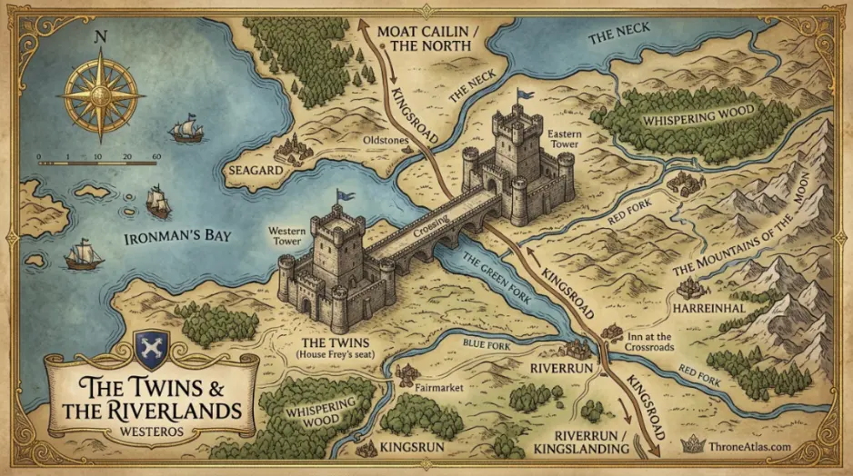
The Twins Map — The Twins map is about one brutal fact: House Frey controls a bridge that armies need. The crossing over the Green Fork turns a minor house into a gatekeeper of northern-southern movement, and that geography explains both Robb Stark’s bargain and the Red Wedding’s strategic consequences.
The Twins map is about one brutal fact: House Frey controls a bridge that armies need. The crossing over the Green Fork turns a minor house into a gatekeeper of northern-southern movement, and that geography explains both Robb Stark’s bargain and the Red Wedding’s strategic consequences.
What This The Twins Map Shows
Use these cards as the two-minute orientation before opening the route map or reading the full atlas guide.
Key takeaways for featured snippets
- The Twins are powerful because they control movement, not because they are beautiful or ancient.
- The Green Fork crossing can delay or redirect an army.
- House Frey’s leverage comes from geography multiplied by opportunism.
- The Red Wedding makes more sense when the bridge is understood as a strategic choke point.
Explore the Main Locations and Pressure Points
Tap a location to see its role, route connection and why it matters inside the wider ThroneAtlas network.
East Twin
One tower guards the eastern approach and turns passage into negotiation.
The Twins Map: Complete Location Guide
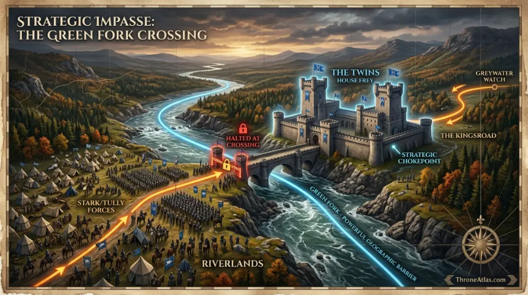
A strong The Twins Map should do more than name the famous place. It should explain why green fork creates pressure, how bridge control is projected across nearby roads or waters, and why the story keeps returning to river crossing whenever claims, sieges, envoys or betrayals begin to move. That is the purpose of this ThroneAtlas version: the page is built as a map-reading guide first, then as a lore guide, so readers can understand the location in seconds and still have enough depth for a full atlas article.
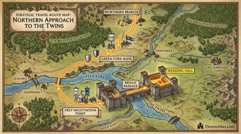
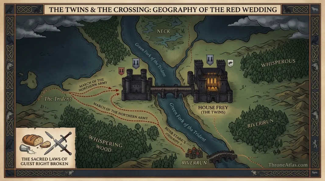
The most useful way to read this map is to follow the route sequence: Northern March → Green Fork Bank → Frey Negotiation → Bridge Passage → Wedding Hall. This order turns the page from a simple location description into a cause-and-effect chain. A castle, city, river, road or bay does not matter only because it appears on screen; it matters because it controls who can arrive, who can escape, which house can enforce a claim, and where a private decision becomes a public crisis.
For searchers comparing pages across the ThroneAtlas network, the location cluster starts with East Twin, West Twin, Green Fork, Wedding Hall. These points are not filler labels. They are the core anchors that make the map easy to use for readers who want fast answers, visual context, internal links and story geography in one place.
How Geography Creates Story Pressure
The first layer is physical. Roads, rivers, walls, cliffs, gates, harbors, forests, deserts or ruins decide who can reach the location and how costly that movement becomes. On this page, the pressure point is River crossing. That phrase is not just a label; it is the part of the map that forces characters to choose between speed, safety, loyalty and ambition.
The second layer is political. Bridge control gives the location its strategic value. If a house controls the local route, it gains leverage. If a claimant controls the symbolic center, the claim looks stronger. If an enemy controls the access point, even a powerful castle can become isolated. That is why map-reading often explains a scene before dialogue does.
Physical Layer
Green Fork shapes movement, supply, visibility and danger. This is the layer casual viewers often miss when they only remember the famous room or castle name.
Political Layer
Bridge control turns the location into leverage. Whoever understands this layer can turn geography into bargaining power.
Main Locations on the The Twins Map
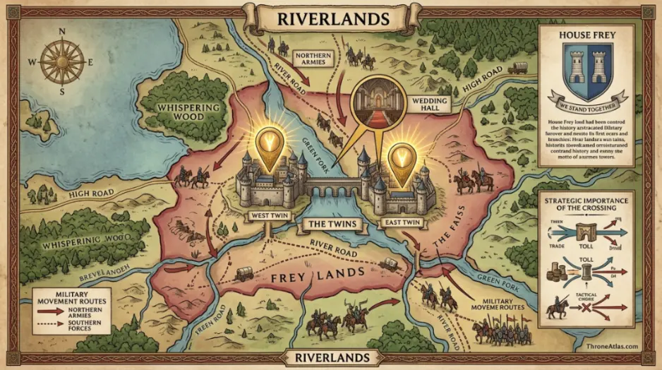
The best map pages do not treat every label equally. The six points below are the practical reading order for this atlas guide. Together they explain the location’s defenses, weaknesses, symbolic meaning and route value.
East Twin
Bridge tower: One tower guards the eastern approach and turns passage into negotiation.
West Twin
Opposite tower: The second tower completes the trap-like geography of the crossing.
Green Fork
River barrier: The river makes movement expensive and gives the Freys leverage.
Wedding Hall
Political ambush: The hall becomes infamous because hospitality and geography combine into a strategic trap.
River Road
Army movement: The road explains why Robb cannot simply ignore the bridge.
Frey Lands
Local influence: The surrounding lands are less important than the crossing itself.
Route Logic: How to Read the Page Like a Maester
Follow the route table below instead of scanning randomly. It turns the page into a story sequence. Each point represents a decision zone: someone arrives, blocks a crossing, opens a gate, controls a chamber, survives terrain, or uses the location’s reputation to change the balance of power.
Book, Show and Atlas Context
This page is designed to work for different types of readers. Some visitors arrive from the HBO shows and want to know where a scene belongs. Others come from the books and want a clearer mental map of houses, roads and regions. The safest approach is to separate confirmed geography from adaptation emphasis. A location may become more important on screen because a conversation happens there, but its deeper map value usually comes from older roads, older houses and older conflicts.
For House of the Dragon, the same principle matters even more. The Dance of the Dragons is not only a family war. It is a map war: island seats, river crossings, castles, old capitals, dragon routes and marriage alliances all decide where power can actually travel. A page like this helps readers understand why an envoy is sent, why a castle is courted, why a fleet matters, and why a symbolic room can become more dangerous than a battlefield.
Common Map Mistakes to Avoid
One mistake is treating the location as if it floats alone. Every castle or city belongs to a wider network. The correct reading starts with the nearby roads, water, regional houses and political loyalties. Another mistake is judging map importance only by size. Some smaller places matter because they control a bridge, pass, gate, harbor or council chamber. Finally, do not confuse visual beauty with strategic safety. A beautiful place can be vulnerable, and a ruined place can still decide a war.
For this specific guide, the clearest shortcut is to ask three questions: what does the location control, who needs that control, and what happens if control changes? Those questions keep the map useful for SEO searchers, lore readers and casual fans who only remember the big scenes.
Why This Page Is Built for SERP-Level Usefulness
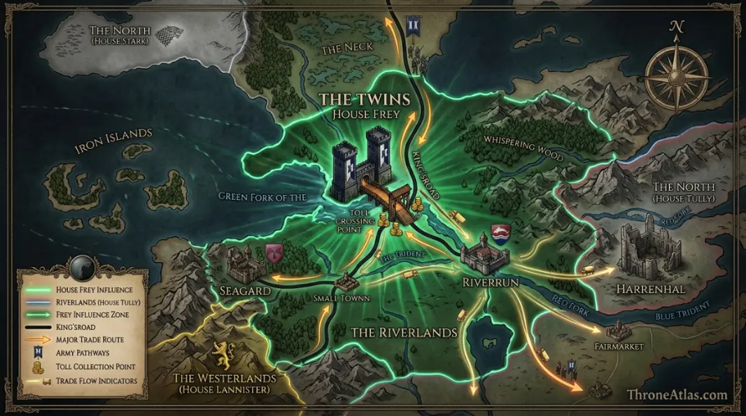
The page is intentionally structured for fast answers and long reading. The hero gives the topic, the quick-answer box targets featured snippets, the fact cards summarize the map, the interactive lens makes the location scannable, and the route table turns the guide into a practical walkthrough. The goal is not to produce a thin fan wiki clone. The goal is to make a page that answers location, route, faction, symbolism, book/show context, and related-page discovery in one clean layout.
That structure also supports internal linking. A reader who enters through this page can move naturally to Riverlands map, then to the wider Westeros map, house pages, battle pages or character journey pages. This is how ThroneAtlas builds topical authority: each page stands alone, but every map also strengthens the atlas around it.
Reader Paths: How Different Fans Should Use This Map
For quick-search readers: start with the quick answer and the four fast facts. That gives the location, the power axis, the main pressure point and the best related page without forcing you through a long lore essay. This is especially useful when you only need to remember where The Twins Map fits inside the wider Westeros map before watching an episode, writing a recap, or checking a character route.
For book and lore readers: spend more time with the route table and the location cards. The deeper value of this page is not merely that it names East Twin, West Twin and Green Fork. The value is that it explains how those points interact. George R. R. Martin’s world often turns small geographic details into major political consequences, so roads, rivers, gates, harbors, ruins and audience chambers can matter as much as armies.
For atlas builders and internal linking: use this page as a hub inside the ThroneAtlas topical cluster. It should connect naturally toward Riverlands map, wider regional maps, house guides, battle maps and character journey maps. That network gives readers more than a single answer; it lets them move from location to region, from region to house, and from house to conflict.
Location-by-Location Reading Notes
The six map anchors below create the strongest topical footprint for this page. Each one should be understood as a search-friendly subtopic, an internal-link opportunity and a visual section anchor. Together they help the page compete not only for the main keyword, but also for long-tail searches around routes, power centers, surrounding regions and story events.
East Twin
East Twin should be treated as the first orientation point because it carries the clearest connection to Bridge control. When readers remember only one label from this map, this is usually the one that explains why the page exists.
West Twin
West Twin adds movement logic. It shows how a route, chamber, river, road or coastline changes the cost of entry and the risk of leaving. This is where geography starts shaping decisions.
Green Fork
Green Fork gives the map its human pressure. Whether the point represents smallfolk, bannermen, envoys, heirs, rangers, maesters or soldiers, it reminds readers that locations matter because people must live inside their consequences.
Wedding Hall
Wedding Hall is the supporting anchor that makes the page feel complete. It widens the map beyond the most famous label and helps the guide avoid the thin, one-location style common on weaker SERP pages.
Featured-Snippet Answer Bank
What is the simplest explanation? The Twins map is about one brutal fact: House Frey controls a bridge that armies need. The crossing over the Green Fork turns a minor house into a gatekeeper of northern-southern movement, and that geography explains both Robb Stark’s bargain and the Red Wedding’s strategic consequences.
What controls the map? The controlling idea is Bridge control. Whoever can influence that axis can affect travel, legitimacy, military timing or public perception around The Twins Map.
What creates danger? The danger point is River crossing. In practical map terms, this is the pressure that forces characters into bargains, delays, sieges, ambushes, ceremonies, escapes or public decisions.
What should readers study next? The best next step is Riverlands map, because it expands this page into the surrounding region and helps readers understand why the location matters beyond a single scene.
Practical Atlas Use Cases
Use this map when you are trying to place a scene, follow a character journey, compare a house seat with a battlefield, or understand why a council decision creates consequences far away from the room where it is made. A strong atlas page should answer both “where is it?” and “why does it change the story?” That second question is what separates a thin location note from a page that deserves to rank.
For publishing, this section also gives the page more topical depth without drifting away from the focus keyword. It reinforces the main map entity, nearby sub-entities, route words, regional terms, and reader intent in natural language. The result is a page that can serve casual fans, lore researchers, image search, AI answer engines and internal-link crawlers at the same time.
Most importantly, the page keeps the reader on a clear path. It opens with a direct answer, then adds evidence through geography, then gives visual anchors, then sends the reader toward related atlas pages. That flow is stronger than a scattered lore dump because it respects both search intent and real fan curiosity.
Final Map Reading Summary
Use this The Twins Map as a layered atlas: begin with the quick answer, confirm the main theater, identify the pressure point, follow the route table, then explore the related pages. Once you read the location this way, the story becomes easier to follow because geography stops being background decoration and becomes the engine behind every claim, siege, alliance and betrayal.
The Twins Map Questions
Short answers for readers, search snippets and AI overview style queries.
The Twins map is about one brutal fact: House Frey controls a bridge that armies need. The crossing over the Green Fork turns a minor house into a gatekeeper of northern-southern movement, and that geography explains both Robb Stark’s bargain and the Red Wedding’s strategic consequences.
The Twins Map matters because it brings together green fork, bridge control, and the pressure of river crossing. On the map, this creates a location where travel, war, court politics, family loyalty and symbolism overlap.
Start with East Twin, then follow the route toward Wedding Hall. That path shows how the location functions in story terms rather than just where it sits on the continent.
Yes. The guide is written for both series contexts where relevant. It keeps the map logic clear without relying on unaired speculation, while still connecting the location to House of the Dragon, Game of Thrones and the wider A Song of Ice and Fire geography.
Read Riverlands map next, then follow the related links at the bottom for the wider network around green fork.
Related ThroneAtlas Pages
Use these links to keep the topical cluster connected and help readers move through the wider map network.