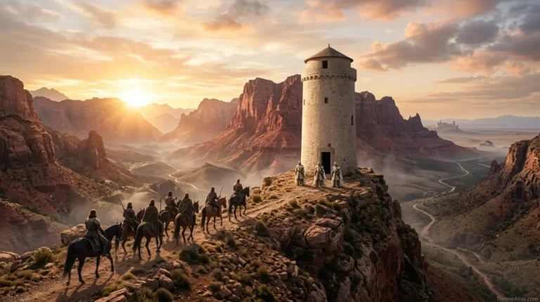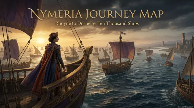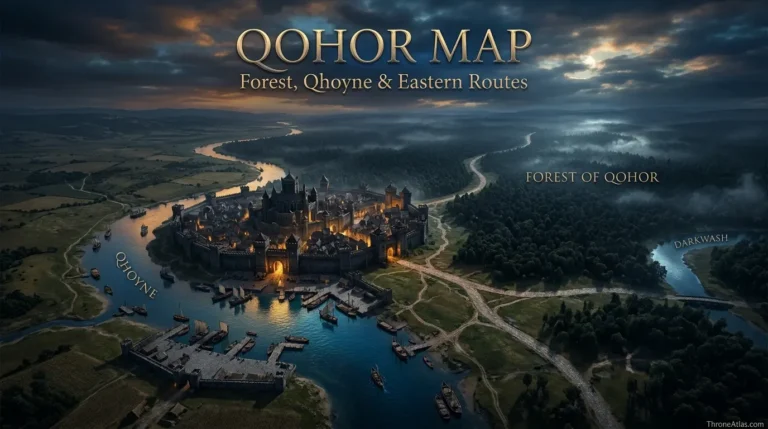
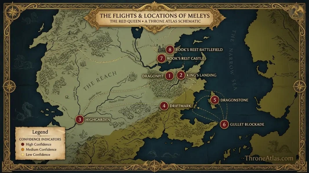
Meleys Locations Map
Meleys, the Red Queen, has one of the clearest multi-generation dragon routes. By 75 AC she resides in the Dragonpit in King’s Landing, where Princess Alyssa Targaryen claims her. With Alyssa she flies around the royal world; with Princess Rhaenys, who claims Meleys in 87 AC, the route expands to Highgarden, royal-progress travel and the Velaryon world around Driftmark. During the Dance, Rhaenys and Meleys support the black blockade from the Dragonstone–Driftmark region. In 129 AC they fly alone to relieve Rook’s Rest and are killed after fighting Sunfyre and Vhagar.
Key Takeaways
Dragonpit
This is a dragon-locations atlas. Confirmed lairs, rider bases and battles are mapped as fixed anchors, while routine flights and unrecorded paths remain broad corridors.
King’s Landing airspace, Highgarden and Driftmark
Confirmed anchors and reconstructed corridors are separated.
Rook’s Rest battlefield
Maintained for 2026.
Visual Atlas
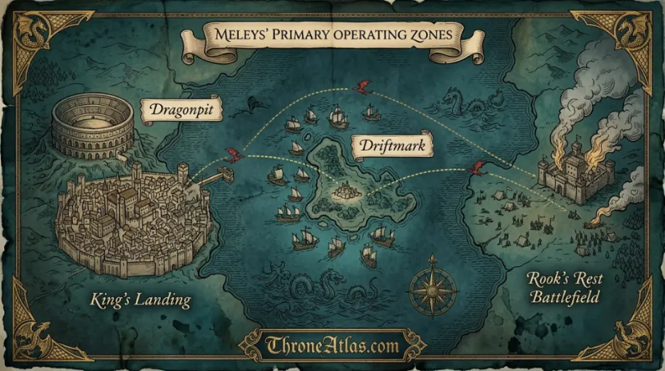
Each marker explains the geographic evidence behind the map.
Mapped Locations and Confidence
| Location / Phase | Confidence | Why it belongs on the map |
|---|---|---|
| 1. Dragonpit | High | Meleys resides in the Dragonpit by 75 AC and is claimed there by Princess Alyssa Targaryen. |
| 2. King’s Landing airspace | High | Alyssa regularly rides Meleys from the capital, establishing King’s Landing as the first sustained operating base. |
| 3. Highgarden | High | Rhaenys flies Meleys to Highgarden in 89 AC to accompany Jaehaerys’s royal progress. |
| 4. Driftmark | High | Rhaenys’s marriage to Corlys Velaryon ties Meleys strongly to the Velaryon island and Blackwater Bay. |
| 5. Dragonstone | High | During the Dance, Dragonstone becomes one of the black faction’s principal bases and a key anchor beside Driftmark. |
| 6. Gullet blockade zone | High | Rhaenys and Meleys are intended to provide aerial cover over the Velaryon blockade controlling access to Blackwater Bay. |
| 7. Rook’s Rest | High | Rhaenys answers Lord Staunton’s plea and flies Meleys alone to the besieged crownlands castle. |
| 8. Rook’s Rest battlefield | High | Meleys fights Sunfyre and Vhagar above the fields and dies after the three dragons crash to the ground. |
1. Dragonpit
Meleys resides in the Dragonpit by 75 AC and is claimed there by Princess Alyssa Targaryen. This marker belongs on the page because it fixes a major phase of the subject to a real geographic relationship. Read it with the adjacent points to understand sequence, terrain and political meaning together.
2. King’s Landing airspace
Alyssa regularly rides Meleys from the capital, establishing King’s Landing as the first sustained operating base. This marker belongs on the page because it fixes a major phase of the subject to a real geographic relationship. Read it with the adjacent points to understand sequence, terrain and political meaning together.
3. Highgarden
Rhaenys flies Meleys to Highgarden in 89 AC to accompany Jaehaerys’s royal progress. This marker belongs on the page because it fixes a major phase of the subject to a real geographic relationship. Read it with the adjacent points to understand sequence, terrain and political meaning together.
4. Driftmark
Rhaenys’s marriage to Corlys Velaryon ties Meleys strongly to the Velaryon island and Blackwater Bay. This marker belongs on the page because it fixes a major phase of the subject to a real geographic relationship. Read it with the adjacent points to understand sequence, terrain and political meaning together.
5. Dragonstone
During the Dance, Dragonstone becomes one of the black faction’s principal bases and a key anchor beside Driftmark. This marker belongs on the page because it fixes a major phase of the subject to a real geographic relationship. Read it with the adjacent points to understand sequence, terrain and political meaning together.
6. Gullet blockade zone
Rhaenys and Meleys are intended to provide aerial cover over the Velaryon blockade controlling access to Blackwater Bay. This marker belongs on the page because it fixes a major phase of the subject to a real geographic relationship. Read it with the adjacent points to understand sequence, terrain and political meaning together.
7. Rook’s Rest
Rhaenys answers Lord Staunton’s plea and flies Meleys alone to the besieged crownlands castle. This marker belongs on the page because it fixes a major phase of the subject to a real geographic relationship. Read it with the adjacent points to understand sequence, terrain and political meaning together.
8. Rook’s Rest battlefield
Meleys fights Sunfyre and Vhagar above the fields and dies after the three dragons crash to the ground. This marker belongs on the page because it fixes a major phase of the subject to a real geographic relationship. Read it with the adjacent points to understand sequence, terrain and political meaning together.
Meleys links two generations of Targaryen women
Alyssa and Rhaenys give the Red Queen a longer geographic history than dragons bonded only during the Dance. King’s Landing, royal-progress destinations and later Velaryon strongholds all belong to one dragon’s life.
Speed shapes the early map
Meleys is famous for being exceptionally swift. That matters because royal-progress travel and movement between court centers could be completed differently by a fast dragon than by an army or wagon train.
Driftmark changes her political geography
Rhaenys’s marriage to Corlys Velaryon moves the dragon into the maritime power system around Blackwater Bay. Meleys becomes connected not only with Targaryen royalty but with Velaryon fleets and island strategy.
The Gullet gives Meleys a naval-defense role
The blockade is a fleet operation, but dragons alter the naval balance. Rhaenys’s planned overhead presence shows how air power and sea power are meant to support each other.
Rook’s Rest is a deliberate trap
Rhaenys responds to a real siege, but the greens have positioned Sunfyre and Vhagar for the confrontation. The map makes the distance from black bases to the isolated crownlands castle part of the tactical story.
The final battlefield is tightly placed
Rook’s Rest sits on the northern shore of Blackwater Bay, west of Crackclaw Point. The castle and surrounding fields provide a firmer final coordinate than the vague battle zones of many older wars.
Dragon maps need rider chronology
A dragon can outlive a rider, remain riderless for years and later accept someone new. The map therefore follows phases rather than assuming one continuous political allegiance. Residence, rider and faction can all change while the dragon remains the same geographic subject.
Lairs are stronger evidence than imagined flight lines
When a source names a cave, yard, pit or island where a dragon lairs, that is high-value geographic evidence. Long-distance flights are often recorded only by destination. ThroneAtlas prioritizes the fixed lair and event site over smooth lines that look precise but are not documented.
Dragons compress distance but do not erase strategy
A dragon can cross terrain far faster than an army, yet riders still need castles, fleets, allies and objectives. Dragonstone, the Gullet, King’s Landing and Tumbleton matter because they are strategic systems below the flight path.
Book and screen routes remain separate
House of the Dragon may rearrange encounters or show journeys not described in Fire & Blood. This atlas uses the published historical geography as its structural base and does not silently convert adaptation scenes into book-canon coordinates.
How to read the Meleys Locations Map
Begin with Dragonpit, then locate Driftmark, and finally follow the page toward Rook’s Rest battlefield. Those three anchors establish the center, a major transition and the outer consequence of the map. They are not necessarily three consecutive stops; on a battle or house page they may represent strategic phases rather than a literal journey.
This is a dragon-locations atlas. Confirmed lairs, rider bases and battles are mapped as fixed anchors, while routine flights and unrecorded paths remain broad corridors.
The atlas keeps physical geography separate from temporary political control. A castle can change hands without moving. A dragon can change rider or faction while keeping the same lair. A house can lose lands while its ancestral seat remains fixed. That separation lets the page remain useful across different periods.
Distance, movement and practical geography
Fantasy maps invite straight-line assumptions, but real movement inside the story follows practical constraints. Armies need roads, food and safe crossings. Ships need navigable water and workable weather. Dragons can ignore many ground barriers, yet their riders still act from castles, ports and allied positions. Noble houses depend on the river and road systems around their seats.
For that reason, ThroneAtlas does not turn every pair of known points into a rigid route. If the source describes only origin and destination, the map shows a corridor. If a lair or battlefield is explicitly placed, that point receives stronger confidence. The visual result is intentionally evidence-led rather than decorative.
What changes when you zoom out
At local scale, Dragonpit may dominate the page. Zoom out and it becomes one node inside a larger system. Driftmark may connect the subject to another kingdom, a battlefront, a maritime chokepoint or a royal capital. Rook’s Rest battlefield then shows where that story ends or where its consequences spread.
This is why related maps matter. The same location can play different roles on a regional map, a battle map and a character or dragon route. The geography stays stable while the question changes.
Confirmed geography versus reconstruction
High-confidence markers come from direct place names, published maps or unambiguous narrative positioning. Medium-confidence markers represent broad zones or relationships that are strong but not precise enough for a survey point. Low confidence is reserved for locations or route segments whose exact placement remains unresolved.
Confidence is not the same as importance. A legendary or disputed event can be central to the lore while still being poorly mapped. A small river junction may be geographically exact while receiving only a few lines in the story.
Fast atlas answers
Primary anchor
Dragonpit is the first place to locate for orientation.
Key transition
Driftmark changes the map’s strategic or chronological meaning.
Final connection
Rook’s Rest battlefield gives the clearest endpoint or wider consequence.
Why the geography changes the story
Meleys, the Red Queen, has one of the clearest multi-generation dragon routes. By 75 AC she resides in the Dragonpit in King’s Landing, where Princess Alyssa Targaryen claims her. With Alyssa she flies around the royal world; with Princess Rhaenys, who claims Meleys in 87 AC, the route expands to Highgarden, royal-progress travel and the Velaryon world around Driftmark. During the Dance, Rhaenys and Meleys support the black blockade from the Dragonstone–Driftmark region. In 129 AC they fly alone to relieve Rook’s Rest and are killed after fighting Sunfyre and Vhagar.
Seen as text alone, these events can feel like a sequence of names. On a map, causes become easier to see. Distance explains why relief arrives late. A bay explains why fleets and dragons operate together. A river confluence explains why a house seat is prosperous. A mountain, forest or castle network explains why an invading army chooses several targets at once.
This spatial reading does not replace the narrative. It tests and organizes it. A good atlas lets readers move back to the story with a clearer sense of what was physically possible, which locations were close, and why commanders or riders made particular choices.
Time, control and changing meaning
Many locations on this page change meaning over time. A dragon lair can become a military base. A town can become a battlefield. A castle can shift from family home to invasion target. A route can carry merchants in peace and armies in war. The page describes those phases rather than freezing one moment as permanent geography.
Chronology is therefore embedded in the numbered sequence and the written sections. The visual atlas should be read as a layered overview, not as proof that every marker represents the same day or political situation.
Cartographer’s field notes
The strongest atlas pages are comfortable leaving some space unresolved. Not every stretch of road has a name. Not every dragon flight has a recorded path. Not every noble estate has surveyed borders. Filling those gaps would make the graphic look complete while making the information less reliable.
The three image positions are designed for different jobs. The hero establishes atmosphere and region. The primary atlas image should carry the finished geographic visual with labels and terrain. The contextual image can focus on the most important secondary relationship—battlefield, lair, river system, neighboring castle or route. Their alt text describes those roles rather than simply repeating the headline.
If future published material clarifies an uncertain point, the page can be updated without changing the overall structure. That is one advantage of separating confidence from importance: new evidence can move a marker without forcing the whole interpretation to be rewritten.
How this page fits the full ThroneAtlas
The related links below are chosen to change scale or perspective. Regional pages explain the wider landscape. Battle pages show temporary control. House pages explain allegiance. Dragon and character routes add chronology. Using several together gives a clearer picture than forcing every layer into one overcrowded map.
Meleys Locations Map therefore stays focused on one geographic question while still functioning as part of the larger ThroneAtlas network.
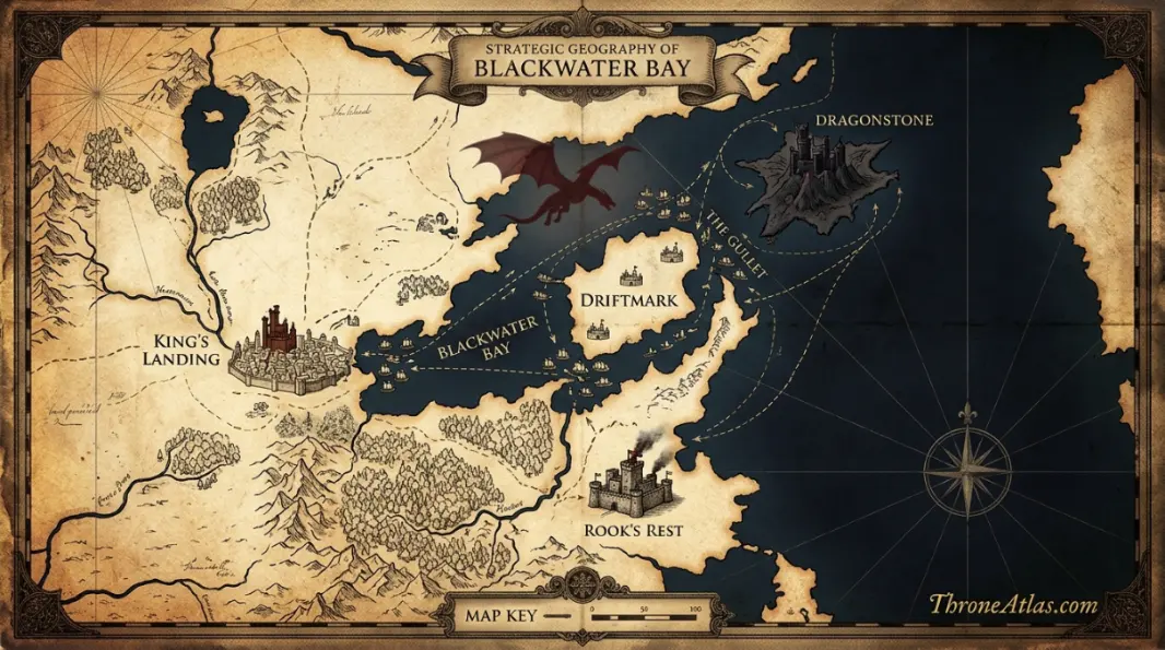
What to compare next
Use the related maps below to change scale. A regional map shows the larger terrain; a battle or city map provides close detail; a house or character page explains political or personal movement. The strongest atlas reading comes from comparing the same anchor across several layers.
This page stays focused on its own geographic question so those connections remain clean and useful rather than repetitive.
Map Accuracy and Canon Confidence
High confidence marks geography directly established in the published material. Medium confidence marks a strong regional reconstruction or grouped phase. Low confidence is reserved for unresolved coordinates or disputed placement.
ThroneAtlas does not add exact borders, flight paths, battle lines or minor roads simply to make the graphic look complete. Where the record becomes uncertain, the atlas keeps that uncertainty visible.
Source Basis
This atlas follows the dragon’s published history in Fire & Blood. King’s Landing, Highgarden, the Velaryon/Dragonstone operating zone and Rook’s Rest are firm anchors; routine flights not preserved by the chronicles remain unmapped.
The page is an interpretive atlas built from established place relationships and chronology. It is designed to answer where events happen, how locations connect and how confidently each part can be mapped.
Frequently Asked Questions
Where does the Meleys locations map begin?
The first major anchor is Dragonpit. From there the atlas follows the strongest chronological or regional sequence.
What is the most important location on this Meleys locations map?
Driftmark is a major turning point, while Rook’s Rest battlefield marks the final or widest consequence of the map.
Is this Meleys locations map based on published canon?
Yes. The base geography follows the published novels, Fire & Blood and official world maps. Uncertain details are labeled rather than presented as equally firm.
Are all map lines exact?
No. Confirmed locations are distinguished from reconstructed corridors. The atlas does not invent a precise flight, march or road where the source only provides destinations.
What does High confidence mean?
High means a place or relationship is directly established by the source geography. Medium marks a strong regional reconstruction. Low is used for genuinely unresolved points.
Why are nearby places included?
Nearby locations explain scale, strategy and movement. Their appearance on the map does not imply ownership or a confirmed visit unless the text says so.
Can I use this map for exact mileage?
No. The visual atlas is designed for relative position, route logic and strategic context rather than modern GPS measurement.
How does ThroneAtlas handle conflicting accounts?
The page preserves the shared geographic facts and identifies where chroniclers disagree instead of choosing one uncertain version without warning.
What should I open next?
The Continue Exploring section links to the strongest regional, battle, house, dragon and location pages connected to the same geography.
When was this Meleys locations map updated?
This ThroneAtlas page is maintained as a 2026 edition and intentionally avoids a fixed day-and-month freshness stamp.