The Reach Map: Highgarden, Oldtown, Houses, Rivers & Battle Routes
A complete atlas of Westeros’s fertile southwest—mapping Highgarden, Oldtown, the Mander, the Arbor, powerful Reach houses and the food, roads and armies that make this region a kingdom-sized strategic engine.
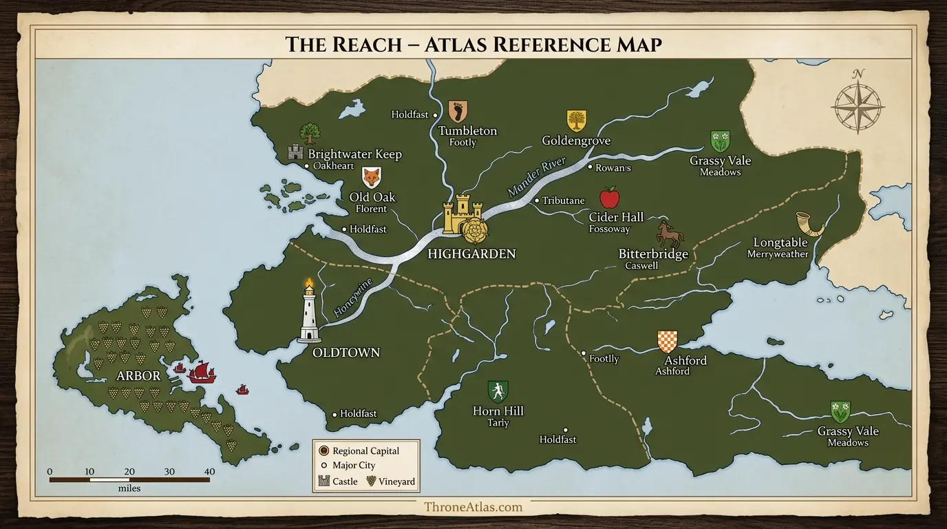
The Reach is the fertile southwestern region of Westeros, historically centered on Highgarden and shaped by the Mander river system. Oldtown adds a second major center through the Hightower and Citadel, while the Arbor contributes naval and wine wealth. The region’s productive land supports large populations and armies, which makes Reach allegiance crucial to King’s Landing, the Dance of the Dragons and the War of the Five Kings.
The Reach Map at a Glance
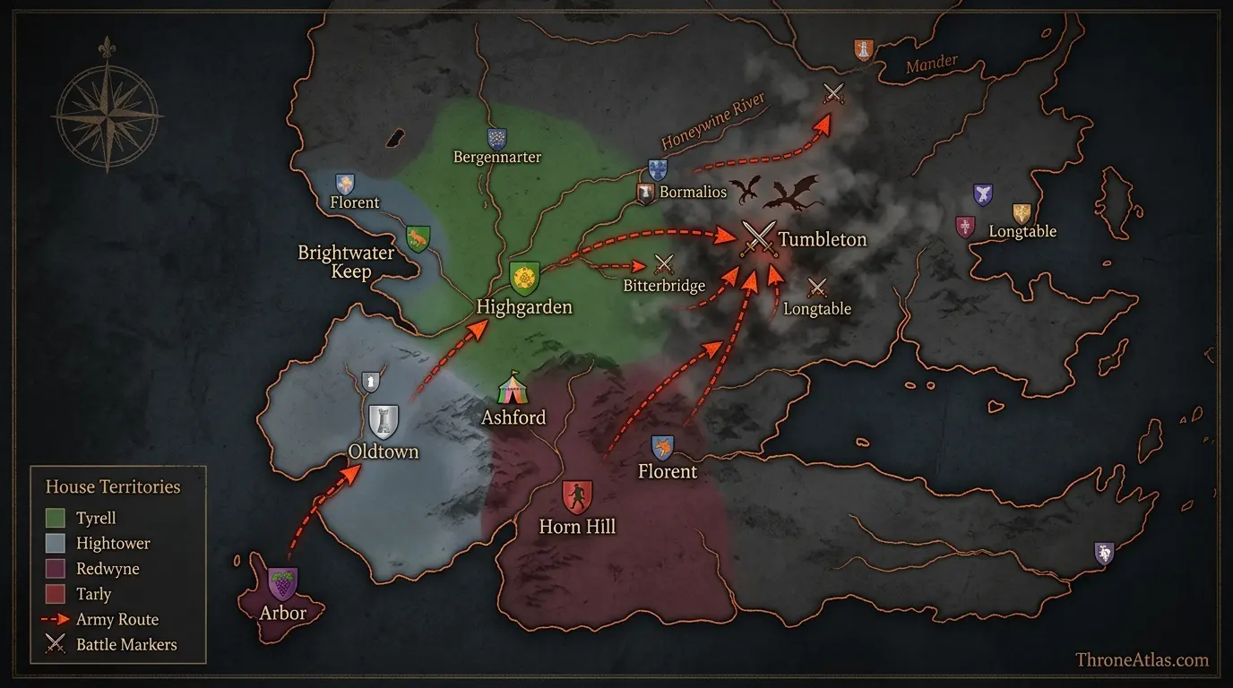
This visual map is the fast geographic reference for the guide below. It is designed to show the places, routes, borders, strongholds or battle zones that matter most to this topic before you move into the deeper lore and strategy.
In This Guide
- Visual Map at a Glance
- What the Reach Map Actually Shows
- Highgarden: Dynastic Center of the Reach
- Oldtown: The Reach’s Second Center of Power
- The Mander River and the Reach’s Agricultural Core
- The Arbor and Redwyne Naval Power
- Horn Hill, House Tarly and the Martial Reach
- Ashford and Tumbleton: When the Reach Becomes a Battlefield
- The Reach Houses: Why One Green Color Is Not Enough
- Why the Reach Can Feed King’s Landing—and Starve It
- The Reach Across the Conquest, Dance and Game of Thrones
The Reach Map: Highgarden, Oldtown, Houses, Rivers & Battle Routes: What Matters Most
Regional seat
Highgarden, first Gardener and later Tyrell.
Great city
Oldtown combines trade, the Hightower, Citadel and religious history.
Main river
The Mander organizes much of the fertile agricultural core.
Island power
The Arbor gives House Redwyne maritime and commercial strength.
Martial house
Horn Hill anchors House Tarly’s military reputation.
Event locations
Ashford and Tumbleton become important when people and armies converge.
Political depth
Hightower, Redwyne, Tarly, Florent and other houses make the Reach multipolar.
Strategic resource
Food production can sustain armies and stabilize—or destabilize—the capital.
Places to Plot on the Map
| Location | Region / Zone | Why It Matters | Map Reading |
|---|---|---|---|
| Highgarden | Central Reach | Traditional regional seat. | Dynastic center |
| Oldtown | Southwest / Honeywine | Major city, Citadel and Hightower. | Urban / institutional center |
| Mander | Region-wide | Major river through fertile heartland. | Agricultural / transport system |
| The Arbor | Southwest island | Redwyne wine and fleet power. | Maritime economy |
| Horn Hill | Reach interior | House Tarly seat. | Military house |
| Ashford | Reach | Dunk and Egg tournament setting. | Event node |
| Tumbleton | Northeastern Reach corridor | Major Dance of the Dragons war site. | Military staging / battle node |
| Honeywine | Oldtown corridor | River supporting city and surrounding lands. | Urban waterway |
What the Reach Map Actually Shows
The Reach map shows the fertile southwest heartland of Westeros, centered on the Mander river basin and historically ruled from Highgarden. Oldtown, the Arbor, Horn Hill, Tumbleton, Ashford and numerous powerful houses make the region a combined agricultural, commercial, religious, intellectual and military power base.
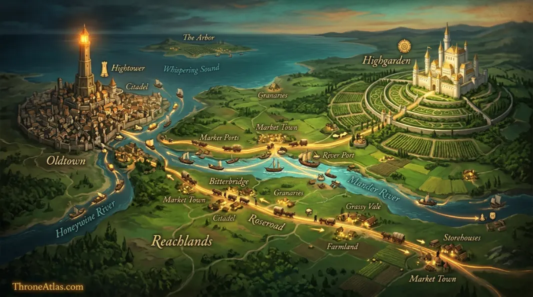
The Reach is easy to reduce to flowers and food. That misses its strategic scale. Fertility means population. Population means taxes, levies, labor and markets. The Mander and coastal routes connect estates to ports, while Oldtown adds one of the realm’s greatest cities, the Citadel and the Faith’s historic center. The Arbor adds maritime wealth and wine. Highgarden adds dynastic symbolism. Together, these assets make the Reach one of the hardest regions for any crown to ignore.
Its abundance also creates internal competition. House Tyrell becomes the lord-paramount dynasty after Aegon’s Conquest, but houses such as Hightower, Redwyne, Tarly, Florent, Rowan and Oakheart have deep roots and significant independent resources. A map colored simply “Tyrell” can hide how many power centers operate beneath that banner.
The Reach therefore works best as a network map. Follow the Mander, the roads toward King’s Landing, the Oldtown-Honeywine corridor, the Arbor’s sea connections and the castles of major bannermen. Once those lines are visible, the region stops looking like decorative green space and starts looking like the logistical engine of southern Westeros.
Highgarden: Dynastic Center of the Reach
Highgarden is the traditional political heart of the Reach, first under House Gardener and later under House Tyrell. Its importance comes from more than beauty: it sits inside a rich agricultural region and represents control over the noble network that can feed and field some of the largest forces in Westeros.
The castle’s political symbolism predates the Tyrells. House Gardener ruled as kings from Highgarden before Aegon’s Conquest, so the seat carries the memory of an independent Reach kingdom. When the Gardeners die at the Field of Fire and the Tyrells are elevated, the dynasty changes but the geographic center does not.
This continuity matters for regional politics. Old houses can respect the power of Highgarden while still remembering older status claims. The Florents, Hightowers, Redwynes and others are not simply minor satellites. Their wealth and lineage create a layered aristocracy that a lord paramount must manage through marriage, patronage and alliance.
In Game of Thrones, control of Highgarden becomes tied to food supply and the politics of King’s Landing. A capital with hundreds of thousands of residents cannot eat crowns or gold. The Reach’s harvests make Highgarden’s political alignment material to the survival of the royal city.
Oldtown: The Reach’s Second Center of Power
Oldtown is one of Westeros’s oldest and largest cities, located on the Honeywine in the southwest Reach. The Hightower, the Citadel and the city’s historic association with the Faith make it a center of trade, learning, religion and noble influence that can rival Highgarden in importance without replacing it as the regional seat.
Regional maps often assume one capital means one center. The Reach disproves that. Highgarden provides dynastic leadership, while Oldtown provides urban scale and institutions whose influence extends across the Seven Kingdoms. Maesters trained at the Citadel travel to castles everywhere. Religious authority historically radiates from the city. Merchants connect it to southern and overseas routes.
House Hightower benefits from this concentration without needing the title of Lord Paramount. That makes them an excellent example of how urban geography can create power parallel to formal feudal rank. Their seat rises above a city whose economy and institutions generate influence that a rural castle alone cannot match.
In the Dance of the Dragons, Oldtown also becomes a Green power base through Hightower family connections. Daeron Targaryen’s southern role and the Hightower host make the city’s relationship to roads toward Tumbleton strategically important. The map helps viewers see why the war can continue even when politics in King’s Landing shift.
The Mander River and the Reach’s Agricultural Core
The Mander is the major river system of the Reach and helps organize one of Westeros’s richest agricultural landscapes. Rivers move water, goods and people, while fertile surrounding lands produce grain and other food that can sustain cities and armies far beyond the region.
The phrase “breadbasket of Westeros” is useful only if we map what it means. Food is produced across many estates, collected through local markets and obligations, then moved along roads and waterways. The Reach’s power is therefore distributed through fields and villages as much as castles.
War can weaponize this system. An army based in the Reach has access to abundant forage and recruitment compared with a force operating in poorer terrain. Conversely, a hostile crown that loses Reach support can face shortages. The politics of Margaery Tyrell’s popularity in King’s Landing are inseparable from the public association between Tyrell arrival and food relief.
The river also connects inland geography toward the sea. Movement does not depend on one kingsroad-style spine. This denser network helps support the Reach’s population and makes the region capable of generating multiple armies under different houses.
The Arbor and Redwyne Naval Power
The Arbor is a large island off the southwestern coast, famous for wine and ruled by House Redwyne. Its maritime position gives the Reach an important naval dimension: ships, trade and island wealth can matter as much to regional power as inland harvests.
The Arbor is geographically separated from the mainland but economically integrated with it. Wine exports create a recognizable product that travels far beyond Westeros, while Redwyne ships give a landed kingdom access to sea power. That combination makes House Redwyne one of the Reach’s most valuable bannermen.
Naval strength is especially important because the Reach faces the Sunset Sea and the waters around the south. Fleets can protect commerce, transport forces and threaten coastal enemies. In dynastic conflicts, the allegiance of an island house can therefore affect theaters far from its vineyards.
A complete Reach map should connect the Arbor visually to Oldtown and the southwestern coast rather than treating it as an isolated decorative island. The sea lane is part of the regional network.
Horn Hill, House Tarly and the Martial Reach
Horn Hill is the seat of House Tarly, one of the Reach’s strongest martial houses. Its presence on the map is a reminder that the region’s identity is not only agricultural abundance; wealthy land can support highly capable warrior traditions and field commanders whose choices matter in realm-wide wars.
Randyll Tarly’s reputation in Game of Thrones makes this point clearly. A fertile kingdom can raise soldiers, but effective command is a separate resource. House Tarly combines land, lineage and military experience, giving whichever coalition secures its loyalty a more dangerous army.
The family’s position also illustrates the layered politics beneath House Tyrell. A bannerman can be powerful enough to matter independently, particularly when royal authority offers rewards or when the paramount house weakens. That is why regional maps should include major secondary seats rather than stopping at Highgarden.
Horn Hill also links the Reach to Samwell Tarly’s personal story, creating a bridge between strategic geography and character geography. The same castle can be a campaign asset to kings and an emotionally difficult home to one character. Atlas pages become richer when they preserve both scales.
Ashford and Tumbleton: When the Reach Becomes a Battlefield
Ashford and Tumbleton show how ordinary Reach towns can become historically famous when armies and tournaments concentrate there. Ashford becomes the setting for Dunk and Egg’s first major adventure; Tumbleton becomes a crucial military node during the Dance of the Dragons because southern forces and dragonriders converge on it.
Neither place begins with the symbolic weight of Oldtown or Highgarden. Their importance is event-driven. That is useful because it shows how maps change through time. A local meadow can become famous for a royal tournament. A market town can become a battlefield because it sits on the route an army needs.
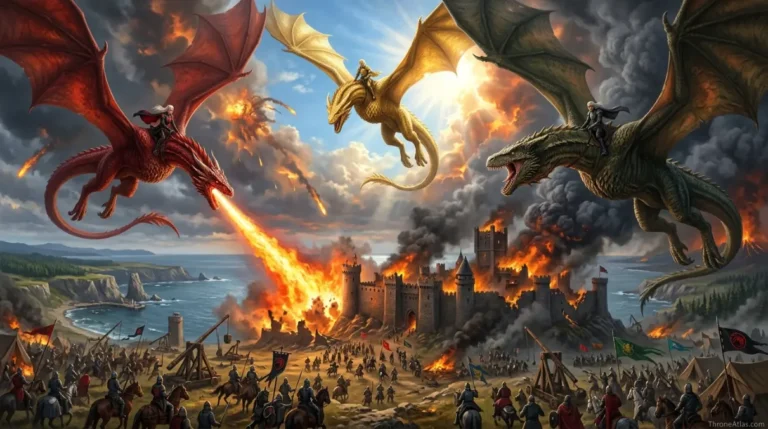
Tumbleton is especially instructive in House of the Dragon Season 3. The Hightower host’s arrival turns the town into a staging area within the southern war. Once dragons and rival forces become involved, its location on routes leading northward from the Reach acquires continent-scale significance.
Ashford works differently. It becomes a temporary political center because nobles gather voluntarily. Together, the two locations demonstrate the two main ways places become important: movement can bring celebration, or it can bring war.
The Reach Houses: Why One Green Color Is Not Enough
Major Reach houses include Tyrell, Hightower, Redwyne, Tarly, Florent, Rowan, Oakheart, Beesbury, Caswell and others. Their estates, marriages and rival claims create a dense power network, so regional allegiance can fracture when the central dynasty loses legitimacy or a civil war offers competing rewards.
The Tyrells’ post-Conquest elevation is especially important to this network. Unlike the Starks in the North, they are not the ancient kings of their region. Other houses can point to prestigious ancestry and substantial resources of their own. The lord paramount must therefore govern through consensus and advantage as much as inherited sacred status.
House Hightower’s urban wealth, Redwyne naval strength and Tarly military reputation illustrate different forms of regional power. House Florent’s claims and old lineage show how genealogy can become political leverage. House Beesbury and Caswell become especially visible in the Dance era.
This variety is why the Reach is potentially decisive in civil war. If the houses move together, the region can deliver food, men, ships and money at enormous scale. If they split, the same resources feed opposing coalitions. The map should make those subregional assets visible rather than coloring the whole southwest as one unit.
Why the Reach Can Feed King’s Landing—and Starve It
King’s Landing depends on imported food, and the Reach is one of the most important sources of surplus agricultural production. Control of roads, harvests and alliances therefore gives Reach houses influence over the capital that does not require them to sit the Iron Throne.
This is soft power made geographic. A city can have walls, gold and soldiers, but if food traffic collapses, political stability deteriorates quickly. Prices rise, resentment spreads and rulers have to spend more resources securing supply. The crowd does not experience geopolitics as a map color; it experiences whether bread is affordable.
During the War of the Five Kings, alliances involving House Tyrell change the supply picture around the capital. That practical contribution helps explain why marriage politics between royal claimants and Reach houses matter so much. A wedding can redirect not only banners but grain.
The same principle applies in other eras. The Reach’s value is persistent because it comes from productive geography. Dynasties change, but fertile land remains a strategic asset as long as people need to eat.
The Reach Across the Conquest, Dance and Game of Thrones
The Reach keeps the same broad geography across centuries while its ruling coalition changes: Gardeners rule before Aegon, Tyrells rise after the Conquest, Hightower influence becomes central during the Dance, and Tyrell alliances shape the War of the Five Kings. The region is stable on the physical map but highly dynamic on the political one.
Comparing eras is the best way to see the difference between geography and government. Highgarden remains a great seat before and after Aegon, but the dynasty occupying it changes. Oldtown remains a major city even when the current royal court is elsewhere. The Arbor keeps producing maritime wealth regardless of who claims the Iron Throne.
That continuity gives regional houses leverage. They can survive royal turnover because their power is rooted in productive places and institutions. A king can grant titles, but he cannot easily recreate Oldtown, the Mander basin or the Arbor somewhere else.
For ThroneAtlas, this makes the Reach an ideal hub page connecting house maps, battle maps, Dunk and Egg locations and House of the Dragon routes. The regional map explains why those stories keep returning to the same southern landscape for very different reasons.
Highgarden, Oldtown and the Reach Network
Continue Exploring ThroneAtlas
The Reach Map: Highgarden, Oldtown, Houses, Rivers & Battle Routes: FAQs
Where is the Reach in Game of Thrones?
The Reach occupies much of southwestern Westeros, with Highgarden as its traditional regional seat and Oldtown as its greatest city. It borders several southern and central regions and reaches the Sunset Sea.
Who rules the Reach?
House Tyrell rules the Reach from Highgarden during the main Game of Thrones era. Before Aegon’s Conquest, House Gardener ruled as kings; the Tyrells were elevated after the Gardeners were destroyed in the Field of Fire.
What is the largest city in the Reach?
Oldtown is the Reach’s great urban center and one of the largest and oldest cities in Westeros. It contains the Hightower and the Citadel, giving it influence far beyond normal city trade.
Why is the Reach called the breadbasket of Westeros?
Its fertile land, river systems and productive estates generate large agricultural surpluses. Those resources feed local populations, support large armies and make Reach alliances especially important to food-hungry King’s Landing.
Where is Highgarden?
Highgarden lies within the fertile core of the Reach and is the traditional seat of regional rulers. It was home to House Gardener before the Conquest and House Tyrell afterward.
Is Oldtown more powerful than Highgarden?
They hold different kinds of power. Highgarden is the formal regional seat, while Oldtown has enormous urban, commercial, intellectual and religious influence through House Hightower, the Citadel and historic institutions.
Where is the Arbor?
The Arbor is an island off the southwestern Reach, ruled by House Redwyne. It is famous for wine and supports a significant fleet and maritime trading network.
Is Tumbleton in the Reach?
Yes. Tumbleton is a Reach town that becomes strategically important during the Dance of the Dragons when major armies and dragonriders converge in its area.
Where is Ashford Meadow?
Ashford Meadow is by Ashford in the Reach. It becomes the setting for the tournament at the center of The Hedge Knight and A Knight of the Seven Kingdoms Season 1.
What are the major houses of the Reach?
Important houses include Tyrell, Hightower, Redwyne, Tarly, Florent, Rowan, Oakheart, Beesbury and Caswell. Their resources and old lineages make the region politically more complex than one ruling-house label suggests.
The Geography Behind the Story
The Reach is the fertile southwestern region of Westeros, historically centered on Highgarden and shaped by the Mander river system. Oldtown adds a second major center through the Hightower and Citadel, while the Arbor contributes naval and wine wealth. The region’s productive land supports large populations and armies, which makes Reach allegiance crucial to King’s Landing, the Dance of the Dragons and the War of the Five Kings. The deeper value of this page is not memorizing names. It is seeing how roads, rivers, coasts, castles, distance, food, dragons, armies, and old political borders determine what characters can realistically do next. That is the layer ThroneAtlas is built to make visible.