Ashford Meadow Map: Tourney Grounds, Trial of Seven & Key Locations
A map-first guide to the tournament ground where Dunk and Egg meet—showing the secure regional geography, functional tourney zones, and the limits of what the books and HBO adaptation actually establish.
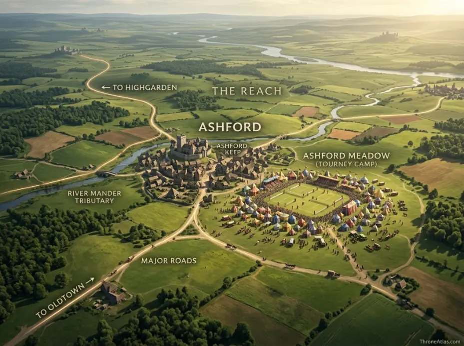
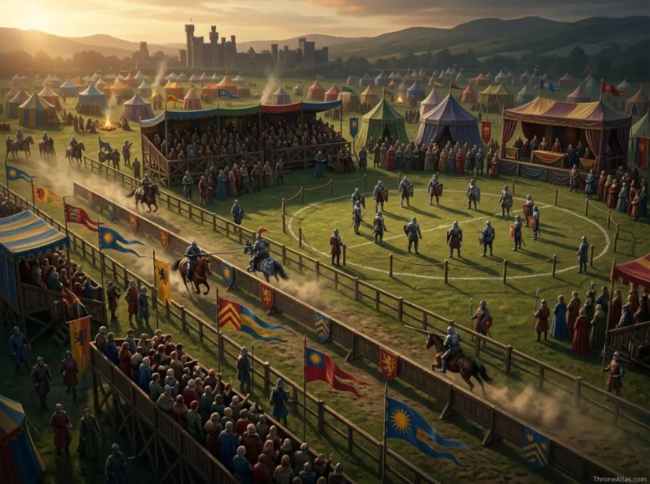
Ashford Meadow is a tournament site by Ashford in the Reach and the principal setting of The Hedge Knight and A Knight of the Seven Kingdoms Season 1. The exact literary tent-by-tent layout is not officially surveyed, but the site can be mapped responsibly through functional zones: the lists, knightly camps, royal pavilions, horse and service areas, spectator movement and the combat ground used for the Trial of Seven.
Ashford Meadow Map at a Glance
This visual map is the fast geographic reference for the guide below. It is designed to show the places, routes, borders, strongholds or battle zones that matter most to this topic before you move into the deeper lore and strategy.
In This Guide
- Visual Map at a Glance
- Where Ashford Meadow Is on the Westeros Map
- The Meadow as a Temporary Medieval City
- The Lists: Where Tourney Geography Becomes Story
- Dunk’s Camp: Why a Small Spot Matters
- The Royal Pavilions and Targaryen Presence
- Where the Trial of Seven Fits on the Map
- Roads Into Ashford: How Everyone Gets There
- Ashford in the Reach: Food, Horses and Tournament Logistics
- Book Map vs HBO Ashford: What Is Actually Canon
- Why Ashford Meadow Matters After the Tournament Ends
Ashford Meadow Map: Tourney Grounds, Trial of Seven & Key Locations: What Matters Most
Region
The Reach, within the fertile south of Westeros.
Story role
Primary setting of The Hedge Knight and the first season of A Knight of the Seven Kingdoms.
Map type
Local event map layered over confirmed regional geography.
Core zones
Lists, camps, pavilions, horse/service areas, crowd routes and Trial of Seven ground.
Dunk’s position
A low-resource hedge-knight camp contrasts with the royal pavilion zone.
Political weight
Targaryen attendance turns a regional tournament into a dynastic event.
Accuracy rule
Do not present a fan-made tent grid as an official book blueprint.
Best use
Understand how physical proximity lets a private act escalate into public royal conflict.
Places to Plot on the Map
| Location | Region / Zone | Why It Matters | Map Reading |
|---|---|---|---|
| Ashford | The Reach | Permanent settlement beside the event landscape. | Regional anchor |
| Tournament meadow | Ashford | Temporary concentration of nobles, knights and crowds. | Primary setting |
| Lists | Tournament zone | Formal jousting ground and public focus. | Functional placement |
| Dunk’s camp | Encampment | Low-status base for Dunk and Egg. | Story zone; exact spot continuity-dependent |
| Royal pavilions | Encampment | Targaryen household and dynastic presence. | High-status zone |
| Trial of Seven ground | Combat zone | Site of extraordinary legal combat. | Functional area; exact measurement uncertain |
| Approach roads | Reach road network | Bring competitors, merchants and spectators. | Regional directional arrows |
Where Ashford Meadow Is on the Westeros Map
Ashford Meadow lies by Ashford in the Reach, within the fertile southern kingdom historically centered on Highgarden. It is not one of Westeros’s great capitals; its importance comes from the tournament that gathers royal princes, famous knights, merchants, camp followers and spectators into one temporary political center.
The first thing to understand about an Ashford Meadow map is scale. Zoom out and the site almost disappears. The Reach contains Oldtown, Highgarden, major rivers, ports, vineyards and some of the richest agricultural land in Westeros. Ashford is a regional place rather than a continent-defining capital. Zoom in during the tournament, however, and the entire social hierarchy of the realm seems to converge on the meadow.
That temporary concentration is why the setting works so well. A tournament needs accessible ground, room for lists and pavilions, grazing and feed for large numbers of horses, water, food, roads and a nearby permanent community capable of supporting visitors. The Reach is particularly suited to that kind of gathering because its wealth is not only stored in castles; it is produced across farmland and market networks.
For mapping purposes, ThroneAtlas places the meadow in its correct regional context while avoiding invented coordinates. The broad answer—Ashford in the Reach—is secure. A precise modern street-style plan is not supplied by Martin and should not be disguised as one.
The Meadow as a Temporary Medieval City
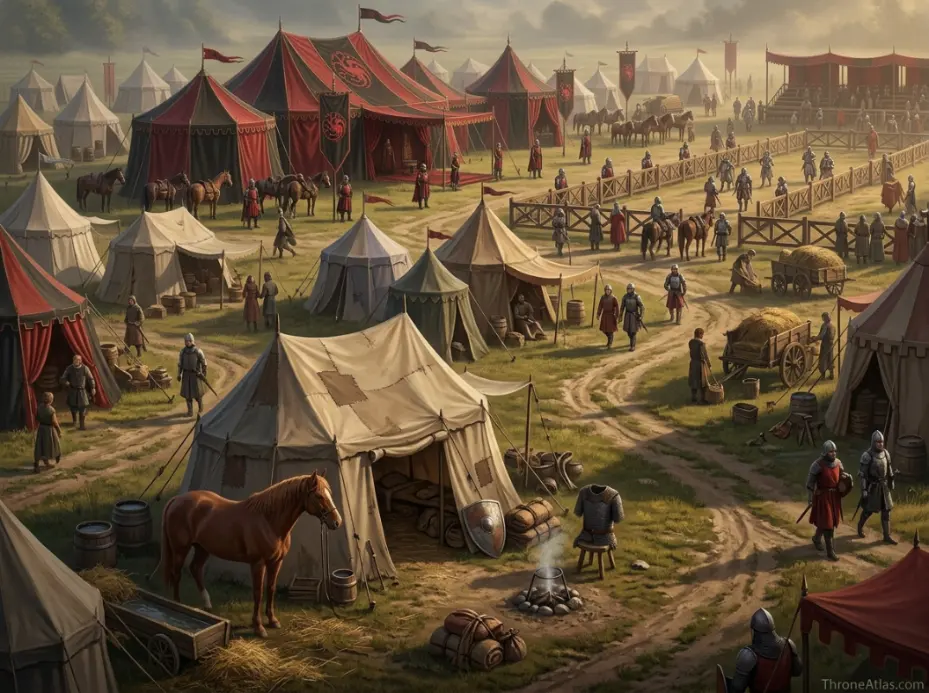
During a major tournament, Ashford Meadow functions like a temporary city. Noble pavilions, knightly camps, horse lines, cooking areas, merchants, spectators, servants and fighting spaces must coexist, turning open ground into a short-lived settlement organized by status, movement and practical needs.
Readers often picture a tournament as one neat arena surrounded by tents. The logistics are messier and more interesting. Hundreds or thousands of people can arrive who do not normally live together. Horses need enormous amounts of fodder and water. Armor must be repaired. Food has to be cooked. Nobles expect privacy. Smallfolk want access to spectacle and trade. Paths between camps quickly become social boundaries as much as physical ones.
Dunk enters this environment from the lowest end of the knightly hierarchy. He does not arrive with a household that reserves a prime pavilion. His location within the camp helps tell us who he is: one hedge knight among many people seeking opportunity around richer patrons. Egg’s presence then complicates that spatial status because the boy who looks like a camp stray belongs to the royal family.
A good local map should therefore think in functional zones rather than pretend every tent has a canonical coordinate. Mark the lists, high-status pavilion area, general knightly encampment, horse/service areas, merchant and spectator flow, and routes toward Ashford. That reveals the social logic of the event without fabricating a blueprint.
The Lists: Where Tourney Geography Becomes Story
The lists are the formal combat space of the tournament: the controlled ground where jousts are staged, reputations are won or lost, and crowds focus their attention. For Dunk, this space represents the public test of whether he can belong to the knightly world he has inherited from Ser Arlan.
In a medieval tournament setting, the lists are more than empty ground. Barriers, approach lanes, viewing positions and places for officials create a ritual space where violence is constrained by rules. That distinction matters because the same meadow later becomes the setting for a much more dangerous legal combat. The physical ground may overlap while the meaning changes.
Dunk’s relationship with the lists is also psychological. He is enormous, physically capable and deeply inexperienced at presenting himself among famous knights. Entering the tourney means stepping from the anonymity of the road into a space where lineage, equipment, heraldry and reputation are visible to everyone. The map can show that threshold: camp on one side, formal public performance on the other.
For screen viewers, the adaptation supplies a visually specific arena. That can be mapped as the HBO layout. For book readers, the safest literary map remains functional rather than architectural, because Martin’s story establishes how the event works without giving a surveyor’s plan.
Dunk’s Camp: Why a Small Spot Matters
Dunk’s place in the encampment should be read as deliberately modest. He arrives without the pavilion train of a great lord, and his camp visually reinforces the economics of hedge knighthood: possessions are limited, horses and armor are livelihood, and a knight without patronage exists close to the edge of respectable society.
Fantasy maps usually privilege castles. Dunk’s story asks us to map a camp. That is not trivial. Where someone sleeps, stores equipment and keeps a horse tells us what resources they control. A great prince carries an ecosystem of servants and protection. A hedge knight carries what he can afford and what his horse can bear.
Egg’s decision to attach himself to Dunk creates one of the story’s quietest reversals. The most politically important child at the tournament can occupy a low-status space because almost nobody recognizes him. Geography becomes disguise. If Egg were sleeping in a royal pavilion, his identity would be obvious; beside Dunk, he can temporarily move through the tournament from below.
This is why a local map should not reduce Dunk’s camp to a decorative icon. It is the narrative base from which he enters the lists, negotiates with other knights, cares for his equipment and gradually becomes entangled with the Targaryen princes nearby.
The Royal Pavilions and Targaryen Presence
House Targaryen’s presence transforms Ashford from a regional tournament into an event with dynastic stakes. Princes, retainers and recognizable royal heraldry create a high-status zone whose political weight is out of proportion to the meadow itself, bringing the conflicts of the ruling family directly beside Dunk’s humble camp.
The contrast between pavilion zones is one of the most useful things to visualize. On one side is a young man trying to prove he is a knight. On another are princes whose names affect succession, marriage alliances and court politics. The physical distance can be short while the social distance is enormous.
Prince Aerion’s behavior collapses that separation. Once Dunk intervenes, a conflict that might have remained a private act of cruelty becomes a confrontation with royal blood. The map then matters because witnesses, allies and potential champions are all already assembled within the same tournament settlement. A place designed to display noble hierarchy creates the conditions for that hierarchy to be challenged publicly.
Egg’s hidden identity is the bridge between the zones. He knows the royal camp from within but chooses to remain with Dunk. The meadow therefore becomes a map of two versions of Targaryen life: power performed through banners and titles, and a prince seeing the same event from the ground.
Where the Trial of Seven Fits on the Map
The Trial of Seven turns Ashford’s martial space into a legal battlefield. Fourteen champions fight under an exceptional form of trial by combat, so the relevant map is not only where the clash occurs but how a public tournament audience, royal authority and the assembled nobility become witnesses to a judgment with deadly consequences.
Because the exact literary footprint is not supplied as a measured plan, ThroneAtlas treats the Trial of Seven area as a designated combat zone connected to the tournament grounds rather than claiming a precise number of yards from a specific pavilion. What matters is functional proximity: the same gathering that brought knights together makes it possible to recruit champions and stage an extraordinary legal contest before the community that will remember it.
The fight permanently changes several lives. It also gives Ashford a place in Targaryen history far beyond the normal importance of a tourney field. A hedge knight’s defense of another person becomes a confrontation involving princes, oaths and death. That is a remarkable change of scale created without moving the story to King’s Landing.
Mapping the Trial separately from ordinary jousting helps readers understand the transition. A tourney is voluntary competitive display. A trial is judgment. The same martial culture supplies both, but the stakes and legal meaning are different.
Roads Into Ashford: How Everyone Gets There
Ashford’s tournament depends on roads more than fortifications. Nobles, wandering knights, merchants and spectators arrive from different parts of the Reach and beyond, so the event is best understood as a temporary hub created where regional travel can feed people and horses into one open site.
The Reach is ideal for road-based storytelling because agricultural prosperity creates dense human movement. Grain, wine, livestock and market goods already travel between holdings. A tournament adds a sudden pulse of elite and popular traffic on top of those ordinary routes. Inns fill, camps expand and local prices likely respond to demand even when the story does not stop to itemize the economy.
For Dunk, the road is entry. For a prince, it is procession. For a merchant, it is opportunity. These travelers can share the same physical track while experiencing it differently. That layered movement is more useful to map than an invented single “Dunk road” with exact turns.
The route arrows on a ThroneAtlas Ashford map should therefore show likely approach directions at regional scale and then fade into the local tournament zone. That communicates access without pretending that an official street grid exists.
Ashford in the Reach: Food, Horses and Tournament Logistics
The Reach matters because a great tournament consumes resources. Fertile farmland, established noble estates and trade networks make it easier to feed visitors and horses than it would be in poorer or more isolated regions. Geography explains why spectacle on this scale is economically plausible.
Horses are the hidden engine of tourney geography. Knights need riding animals, warhorses, replacements, fodder, water and people to care for them. Add noble households, cooks, smiths and crowds, and the event becomes a major temporary burden on the surrounding countryside. The meadow has to work not only dramatically but materially.
The Reach’s fertility provides that background credibility. Its political history is tied to abundance: grain, orchards, vineyards and powerful houses whose wealth comes from productive land as much as treasure. Ashford benefits from being inside that system. The event can draw people because roads and resources exist to support them.
This also makes the later drought geography of The Sworn Sword more striking. The same broad region associated with abundance can become politically tense when water fails. Dunk and Egg’s stories repeatedly show that resources beneath the heraldry matter.
Book Map vs HBO Ashford: What Is Actually Canon
The literary and television versions share Ashford as the setting, but the screen adaptation necessarily fixes camera-visible positions for tents, lists and movement that the novella does not define with survey-level precision. A responsible atlas labels those production-specific placements instead of silently converting them into universal canon.
There is no problem with mapping the HBO version precisely from what appears on screen. In fact, viewers benefit from seeing how a character moves between camp areas and the lists. The problem begins only when that screen layout is presented as though George R. R. Martin supplied it as an official plan for all continuities.
The solution is simple: use layers. “Regional canon” answers where Ashford belongs in the Reach. “Book-functional layout” shows the zones required by the novella. “HBO screen layout” records the visual arrangement used by the series. These layers can overlap while remaining intellectually honest.
This method is especially valuable for AI search and quick answers because it gives a direct response to “where is Ashford Meadow?” without overclaiming details. Clear uncertainty is a strength, not a weakness, when the source itself is not exact.
Why Ashford Meadow Matters After the Tournament Ends
Ashford Meadow matters because it is the birthplace of the Dunk-and-Egg partnership and the site where a seemingly minor hedge knight becomes entangled with Targaryen history. The tents disappear, but the relationships and consequences formed there travel onward across Westeros.
Temporary places can have permanent historical weight. The meadow will return to ordinary use after crowds leave, yet for the characters it can never become ordinary again. Dunk has tested his ideals against royal power. Egg has chosen a life on the road with him. Several princes and knights have revealed who they are under pressure.
This is why ThroneAtlas treats event landscapes with the same seriousness as castles. A castle accumulates importance because people repeatedly occupy it. A tournament field can acquire importance because one concentrated event changes the trajectory of famous lives. Both deserve geographic context.
The natural next step after this page is the Dunk and Egg journey map. Ashford answers “where did the partnership begin?” The journey map answers “where did it go?” Keeping those intents separate gives each page a clearer purpose and stronger internal-link relationship.
The Tourney Ground and Its Surroundings
Continue Exploring ThroneAtlas
Ashford Meadow Map: Tourney Grounds, Trial of Seven & Key Locations: FAQs
Where is Ashford Meadow?
Ashford Meadow is by Ashford in the Reach, the fertile southern region of Westeros. It becomes famous because a major tournament there brings Ser Duncan the Tall, Egg and members of House Targaryen into the same temporary settlement.
Is Ashford Meadow near Highgarden?
Both are in the Reach, but an exact modern-style driving distance should not be invented where the source map does not provide one. Highgarden is the great regional seat; Ashford is a separate local center within the same broad kingdom.
Is there an official detailed Ashford Meadow map?
There is no universally authoritative book blueprint showing every pavilion, lane and combat boundary to scale. HBO provides a screen layout for its adaptation, while book-based maps should distinguish confirmed functions from inferred local placement.
Where did Dunk camp at Ashford?
Dunk camps among the tournament community as a poorly resourced hedge knight rather than within a grand noble household. The narrative importance is the contrast between his modest base and the elaborate royal presence nearby; exact coordinates depend on continuity and depiction.
What are the lists?
The lists are the formal ground used for jousting. They are organized combat space where rules, spectators and reputation matter, distinct from the less formal camp around them and from the exceptional legal stakes of the Trial of Seven.
Where was the Trial of Seven fought?
It takes place at Ashford in connection with the tournament gathering. A map can identify the designated combat ground functionally, but should avoid claiming a surveyed book coordinate unless an official source supplies one.
Why are Targaryen princes at Ashford?
Their attendance gives the tournament royal prestige and creates the conditions for Dunk’s personal conflict to become politically dangerous. Because multiple princes and notable knights are already gathered, the meadow can host an extraordinary legal confrontation.
Is the HBO Ashford layout the same as the book?
Not necessarily in every local detail. Television must create physical sets and movement paths. Those are valid screen-canon geography for the adaptation, while the novella’s geography should be represented at the level the text actually supports.
Why is Ashford important to Dunk and Egg?
It is where their partnership takes shape. Dunk arrives alone and uncertain of his future; he leaves with Egg as his squire after events that force both characters into a lasting bond.
What map should I view after Ashford?
The Dunk and Egg Journey Map is the natural next page because it follows the pair beyond Ashford toward the later settings of Standfast, Coldmoat and Whitewalls.
The Geography Behind the Story
Ashford Meadow is a tournament site by Ashford in the Reach and the principal setting of The Hedge Knight and A Knight of the Seven Kingdoms Season 1. The exact literary tent-by-tent layout is not officially surveyed, but the site can be mapped responsibly through functional zones: the lists, knightly camps, royal pavilions, horse and service areas, spectator movement and the combat ground used for the Trial of Seven. The deeper value of this page is not memorizing names. It is seeing how roads, rivers, coasts, castles, distance, food, dragons, armies, and old political borders determine what characters can realistically do next. That is the layer ThroneAtlas is built to make visible.