Stormlands Map: Storm’s End, Marches, Rainwood & Houses
A map-first guide to the storm-beaten southeastern kingdom of Westeros: Storm’s End, Shipbreaker Bay, Cape Wrath, the rainwood, Tarth, Estermont, marcher castles and the roads that connect King’s Landing, the Reach and Dorne.
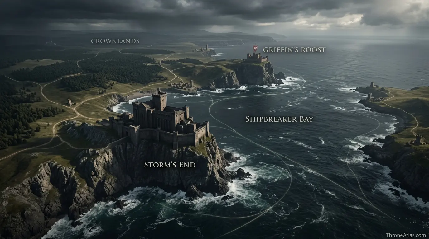
The Stormlands lie south of the Crownlands, east of the Reach and north of Dorne. Storm’s End is the region’s central fortress, Shipbreaker Bay defines its dangerous eastern coast, Cape Wrath carries the rainwood into the narrow sea, and the Dornish Marches form the hard-fought western and southwestern frontier. The region is smaller than the North or Reach, but its coasts, forests, mountains and border castles make it strategically dense.
Stormlands Map — Strategic Geography
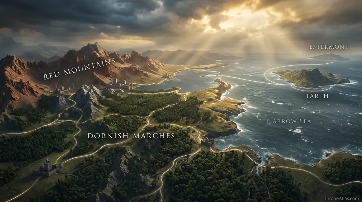
The useful Stormlands map is not a flat list of castles. It is a compact system of coast, storm exposure, wooded peninsulas, marcher approaches and fortified seats. Storm’s End anchors the region, while Tarth and Estermont extend its politics into the narrow sea.
Storm’s End, Cape Wrath, Marches & Islands
Tap a marker to reveal why that place matters. Marker positions are interpretive unless the canon confidence note says otherwise.
Canon Confidence & What This Map Claims
The broad regional relationships are well established in published maps and text, but the exact mile-by-mile borders of many minor stormlord holdings are not. This atlas therefore treats major coasts, castles and regional directions as firm, while local roads and house boundaries remain schematic.
In This Guide
- Visual Atlas & Map
- Canon Confidence
- Map Index
- Where Are the Stormlands on the Westeros Map?
- Storm’s End and Shipbreaker Bay: Why the Seat Is So Hard to Take
- Cape Wrath, Rainwood and the Eastern Stormlands
- The Dornish Marches: A Frontier Built Into the Map
- Tarth, Estermont and the Maritime Stormlands
- How the Stormlands Connect to Robert’s Rebellion and the War of the Five Kings
- Cartographer Field Notes
- Direct Answers
- Source & Canon Basis
- FAQs
Stormlands Map: What Matters Most
Storm’s End is the anchor
The Baratheon seat stands at the region’s political and defensive center, facing notoriously dangerous waters.
Shipbreaker Bay shapes the coast
The bay explains why sea access is valuable but hazardous; coastal movement is never a neutral line on this map.
Cape Wrath is wooded terrain
The rainwood makes the southeast greener, wetter and less open than the famous marcher borderlands.
The Marches face Dorne
Marcher lords developed around a frontier repeatedly contested by the Stormlands, Reach and Dorne.
Tarth adds an island layer
The Sapphire Isle sits east of the mainland and matters to routes through the Straits of Tarth and narrow sea.
Estermont is another sea node
Greenstone and Estermont connect stormlord politics to island travel and maritime defense.
King’s Landing is close enough to matter
The Crownlands border makes the Stormlands one of the capital’s most immediately relevant neighboring regions.
Terrain explains stubborn defense
Rocky coasts, forests, hills, mountains and fortified frontier seats create a region built for resistance rather than easy occupation.
Places, Zones & Connections to Plot
| Place | Zone | Why It Matters | How to Read It on the Map |
|---|---|---|---|
| Storm’s End | Shipbreaker Bay | Ancient storm-seat and later Baratheon stronghold; political heart of the region. | Treat it as the main mainland hub linking coast, Crownlands approaches and marcher roads. |
| Shipbreaker Bay | Eastern coast | Violent waters and rocky approaches give the Stormlands its maritime character. | Sea routes exist, but the bay makes “shortest by water” very different from “safest by water.” |
| Cape Wrath | Southeast peninsula | Large peninsula dominated by the rainwood and coastal storm exposure. | Read it as a wooded projection that separates local land routes from open-sea movement. |
| Rainwood | Cape Wrath | Major forest zone associated with stormland houses and guerrilla-friendly terrain. | Dense woodland reduces the value of simple straight-line army movement. |
| Tarth | Narrow Sea / Straits of Tarth | Island home of House Tarth, east of Shipbreaker Bay. | A maritime waypoint rather than an extension of the mainland road network. |
| Estermont / Greenstone | Narrow Sea | Island seat of House Estermont and a recurring Baratheon connection. | Useful for understanding island politics and shipping south of Shipbreaker Bay. |
| Dornish Marches | Western / southwestern frontier | Historic buffer and battleground between stormlords, Reachmen and Dornish forces. | Read castles here as a defensive chain, not isolated estates. |
| Griffin’s Roost | Western Shipbreaker Bay | Seat of House Connington on the bay’s western side. | Shows how coastal houses guard approaches around Storm’s End and the Crownlands-facing north. |
Where Are the Stormlands on the Westeros Map?
The Stormlands occupy southeastern Westeros, with the Crownlands to the north, the Reach to the west, Dorne and the Sea of Dorne to the south, and Shipbreaker Bay plus the narrow sea to the east.
That location explains why the Stormlands repeatedly become a hinge between larger political theaters. An army moving out of King’s Landing toward Dorne can encounter stormland territory; a force coming east from the Reach can approach the marcher belt; fleets using the narrow sea must account for a coastline famous for bad weather. The region is not enormous, yet it touches several strategic directions at once.
The map also corrects a common visual mistake: the Stormlands are not simply “the land around Storm’s End.” The stormlord world stretches through forests, highlands, islands and marcher country. Storm’s End is the capital-like seat, but the actual region gains its character from the contrast between coastal danger in the east and old land-frontier warfare toward the west and southwest.
For readers following the novels or television series, this geography makes Baratheon power easier to understand. Robert, Stannis and Renly all inherit political meaning from the same regional heartland, but each story uses different parts of it. A map lets those overlapping claims feel concrete instead of abstract.
Storm’s End and Shipbreaker Bay: Why the Seat Is So Hard to Take
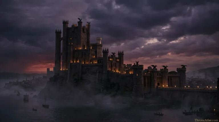
Storm’s End matters because an exceptionally strong castle sits on a storm-lashed coast where land and sea access are both difficult. The fortress is therefore a political symbol and a geographic defensive machine.
The castle’s famous endurance makes more sense when seen in context. Shipbreaker Bay is not a calm harbor wrapped around the stronghold. It is a violent body of water associated with wrecks and dangerous approaches. The result is a seat that cannot be reduced to “a castle beside the sea.” Its coast is part of its defenses, and anyone supplying, besieging or relieving it must solve the geography as well as the walls.
That is why sieges of Storm’s End carry so much narrative weight. A besieging army can control roads and surrounding ground, yet the fortress can still become a stubborn knot on the map. At the same time, a defender trapped inside faces the opposite problem: extraordinary walls do not automatically produce food, allies or an open route to the wider realm. Geography protects and isolates at once.
The dedicated Storm’s End map should handle the local fortress in detail, while this regional page explains its connections. On the Stormlands map, the seat belongs at the center of a network reaching north toward the Crownlands, south along Cape Wrath, west toward the marches and east toward Tarth.
Cape Wrath, Rainwood and the Eastern Stormlands
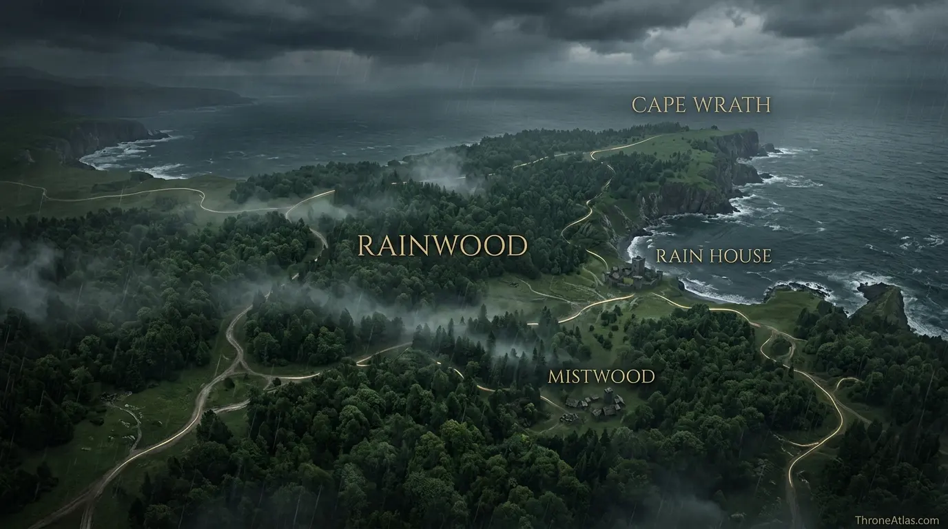
Cape Wrath is the Stormlands’ large southeastern peninsula, bordered by Shipbreaker Bay to the north and the Sea of Dorne to the south; much of it is covered by the rainwood.
This part of the region deserves more attention because it prevents the Stormlands from becoming a one-note map of stony castles and marcher knights. The rainwood introduces dense, wet forest into the political landscape. Roads, patrols and armies do not move through woodland the way they move across open plains, and local houses can use terrain knowledge to make a larger force’s numerical advantage less decisive.
Rain House and Mistwood help turn the peninsula into a chain of local seats rather than empty green space. The map should therefore show both the forest mass and the political points within or around it. When the story references raids, landings or pursuits in the area, the forest is not decoration; it is the medium through which movement has to happen.
Cape Wrath also faces island geography. Estermont sits offshore, while Tarth lies farther north and east. That means the southeastern Stormlands are never purely inland. Lords can think in terms of ships and straits as well as roads, and alliances with island houses create a second layer of movement parallel to the land network.
The Dornish Marches: A Frontier Built Into the Map
The Dornish Marches are the old frontier between the Stormlands, Dorne and the Reach, where castles and marcher houses developed under centuries of raiding, invasion and counterattack.
Frontier geography creates frontier culture. A marcher castle is not merely a noble residence; it exists in a landscape where warnings, passes, patrols and rapid military response historically mattered. Houses such as Dondarrion and Selmy become easier to place when the Marches are understood as a belt of contested approaches rather than one neat political line.
The Red Mountains complicate this border still further. Passes concentrate movement. That makes certain roads and castles disproportionately important: controlling a pass or the approach to it can matter more than holding a wide stretch of rough mountain country. The Stormlands map should therefore emphasize corridors and defensive nodes instead of coloring a large block and calling the job finished.
This history also explains why stormlords and Dornishmen can carry old memories even when the realm is politically unified. Administrative peace does not erase the geography that produced generations of warfare. The map stores that memory in the same way a ruined castle stores history in stone.
Tarth, Estermont and the Maritime Stormlands
Tarth and Estermont show that stormland geography extends offshore: island seats participate in regional politics while also controlling routes through the narrow sea and waters south of Shipbreaker Bay.
Tarth is especially important because it sits near the Straits of Tarth, giving it a natural relationship to shipping around Shipbreaker Bay. Its famous beauty and the “Sapphire Isle” identity can distract from a practical fact: islands are route nodes. They can host fleets, shelter travelers, control local channels and force political actors to think beyond roads.
Estermont plays a smaller but still meaningful role. House Estermont has close dynastic ties to the Baratheons, and the island’s location gives the region a second offshore anchor. A map that omits it makes the Stormlands look more landlocked than they are.
For ThroneAtlas, the key is not to invent naval lanes. Instead, show the relative position of the islands, the mainland peninsulas and the nearby seas. Once those relationships are visible, the reader can understand why a voyage from King’s Landing toward Dorne, the Stepstones or farther east interacts with stormland waters even when no character stops at Storm’s End.
How the Stormlands Connect to Robert’s Rebellion and the War of the Five Kings
The Stormlands repeatedly become politically important because House Baratheon’s home region sits close to King’s Landing and can feed forces toward the capital, the Reach, Dorne or the narrow sea.
During Robert’s Rebellion, the map links the Baratheon seat to a much wider campaign. Battles such as the Battle of the Bells occur outside the Stormlands, yet Robert’s regional identity and network begin here. Storm’s End itself becomes a siege story, demonstrating how a single fortress can hold political value even while the main rebel war moves elsewhere.
The War of the Five Kings turns the same geography inward. Renly and Stannis both claim royal authority from Baratheon roots, but their power bases, allies and movements diverge. Storm’s End becomes a symbolic and operational prize because controlling the ancestral seat strengthens legitimacy in addition to controlling a fortress.
That is the best way to read the region: not as background territory but as a launch platform. The Stormlands are close enough to the capital to matter quickly, rugged enough to resist easy control, and connected enough to southern and eastern theaters that the same roads and coasts can serve very different wars.
How Each Marker Changes the Map
These notes are deliberately practical. They explain what each point does to movement, power, trade, defense, religion or social life instead of repeating a list of place names.
Storm’s End
On the atlas, Storm’s End should not be treated as an isolated pin. Its position in Shipbreaker Bay matters because Ancient storm-seat and later Baratheon stronghold; political heart of the region.. The practical map-reading question is therefore Treat it as the main mainland hub linking coast, Crownlands approaches and marcher roads.. That relationship is more useful than pretending the world has modern surveyed coordinates.
Shipbreaker Bay
Shipbreaker Bay earns a place on this map for a different reason from a famous capital or battlefield. In Eastern coast, Violent waters and rocky approaches give the Stormlands its maritime character.. When following characters, fleets, merchants or armies, read this point through the lens of Sea routes exist, but the bay makes “shortest by water” very different from “safest by water.”; it explains what can realistically happen around it.
Cape Wrath
A good map gives Cape Wrath context, not just a label. Here the relevant geographic frame is Southeast peninsula. Large peninsula dominated by the rainwood and coastal storm exposure.. For route and strategy purposes, the important takeaway is Read it as a wooded projection that separates local land routes from open-sea movement., which is why this location connects naturally to the surrounding markers.
Rainwood
The cartographic value of Rainwood comes from its relationship with the wider Cape Wrath network. Major forest zone associated with stormland houses and guerrilla-friendly terrain.. In practical terms, Dense woodland reduces the value of simple straight-line army movement.. That makes the point meaningful even when the source material never provides exact mileage or a street-by-street survey.
Tarth
On the atlas, Tarth should not be treated as an isolated pin. Its position in Narrow Sea / Straits of Tarth matters because Island home of House Tarth, east of Shipbreaker Bay.. The practical map-reading question is therefore A maritime waypoint rather than an extension of the mainland road network.. That relationship is more useful than pretending the world has modern surveyed coordinates.
Estermont / Greenstone
Estermont / Greenstone earns a place on this map for a different reason from a famous capital or battlefield. In Narrow Sea, Island seat of House Estermont and a recurring Baratheon connection.. When following characters, fleets, merchants or armies, read this point through the lens of Useful for understanding island politics and shipping south of Shipbreaker Bay.; it explains what can realistically happen around it.
Dornish Marches
A good map gives Dornish Marches context, not just a label. Here the relevant geographic frame is Western / southwestern frontier. Historic buffer and battleground between stormlords, Reachmen and Dornish forces.. For route and strategy purposes, the important takeaway is Read castles here as a defensive chain, not isolated estates., which is why this location connects naturally to the surrounding markers.
Griffin’s Roost
The cartographic value of Griffin’s Roost comes from its relationship with the wider Western Shipbreaker Bay network. Seat of House Connington on the bay’s western side.. In practical terms, Shows how coastal houses guard approaches around Storm’s End and the Crownlands-facing north.. That makes the point meaningful even when the source material never provides exact mileage or a street-by-street survey.
Fast Answers About the Map
In southeastern Westeros between the Crownlands, Reach and Dorne, with Shipbreaker Bay and the narrow sea to the east.
Storm’s End is the traditional regional seat and the castle most closely associated with stormlord rule.
The eastern coast is famous for severe storms, especially around Shipbreaker Bay and Storm’s End.
Yes. Tarth is an island politically associated with the Stormlands and lies east of the mainland near the Straits of Tarth.
They form the historic frontier zone toward Dorne and the Reach, especially along approaches influenced by the Red Mountains.
Its proximity to King’s Landing plus difficult coasts, forests, islands and marcher approaches make a compact region unusually important for war and movement.
What This Atlas Is Based On
The Stormlands are unusually easy to oversimplify, so this page cross-checks political history against physical geography rather than treating every house seat as equally important.
- A Song of Ice and Fire: Regional descriptions, house affiliations, routes and political events across the published novels.
- Fire & Blood: Stormland history under the Durrandons, Baratheon rise and Targaryen-era context.
- The World of Ice & Fire: Macro-geography for Shipbreaker Bay, Cape Wrath, the rainwood, islands and marcher history.
- HBO adaptations: Used only for screen-specific staging when relevant; book and show geography are not silently merged.
Continue Exploring ThroneAtlas Maps
Stormlands Map FAQs
Where is Storm’s End on the Stormlands map?
Storm’s End sits on the northern side of Shipbreaker Bay on the eastern coast of the Stormlands. It is the traditional seat of the region and later the ancestral stronghold of House Baratheon.
What is Shipbreaker Bay?
Shipbreaker Bay is a large, stormy bay on the Stormlands’ eastern coast. Its dangerous rocks and waters are part of the region’s identity and help explain the defensive character of Storm’s End.
What is Cape Wrath?
Cape Wrath is the large southeastern peninsula below Shipbreaker Bay. It is heavily associated with the rainwood and includes seats such as Rain House and Mistwood.
Is the rainwood the same as the kingswood?
No. Both are important forests in southeastern Westeros, but the rainwood is associated with Cape Wrath while the kingswood lies closer to the Crownlands and King’s Landing.
Which houses are important in the Stormlands?
House Baratheon dominates the region in the Targaryen and later eras. Other notable stormland houses include Dondarrion, Selmy, Tarth, Estermont, Connington, Caron, Swann, Penrose and others.
Is the Isle of Tarth part of the Stormlands?
Yes. Tarth lies east of the mainland and is politically counted among the Stormlands. Evenfall Hall is the traditional seat of House Tarth.
Why are the Dornish Marches important?
They were a centuries-old military frontier. The geography of mountain approaches and border castles shaped marcher houses around defense, raiding and rapid response.
How close are the Stormlands to King’s Landing?
They border the Crownlands to the south, making them one of the capital region’s closest neighbors. Exact travel times depend on route, weather and destination.
Did House Baratheon always rule the Stormlands?
No. Before Aegon’s Conquest the Storm Kings of House Durrandon ruled from Storm’s End. House Baratheon rose during the Conquest and inherited the regional seat and much of that political legacy.
Is this Stormlands map exact?
Major regional relationships are canon-based, but exact minor-house boundaries and road geometry are often not specified precisely. ThroneAtlas labels those parts as schematic rather than presenting fan reconstruction as surveyed canon.
Why the Stormlands Matter on the Westeros Map
The Stormlands are a compact but strategically loaded region. Storm’s End dominates the political map, Shipbreaker Bay and Cape Wrath define the eastern coast, the rainwood complicates movement, Tarth and Estermont extend the region offshore, and the Dornish Marches preserve an old military frontier. Read together, those features explain why stormlords repeatedly matter far beyond the size of their territory.