Tyrosh Map: Stepstones, Bleeding Tower, Harbor & Disputed Lands
A strategic atlas of Tyrosh, the fortified island Free City positioned beside the Stepstones and Disputed Lands—built to watch shipping, trade aggressively and compete with Lys and Myr for control of the southern routes.
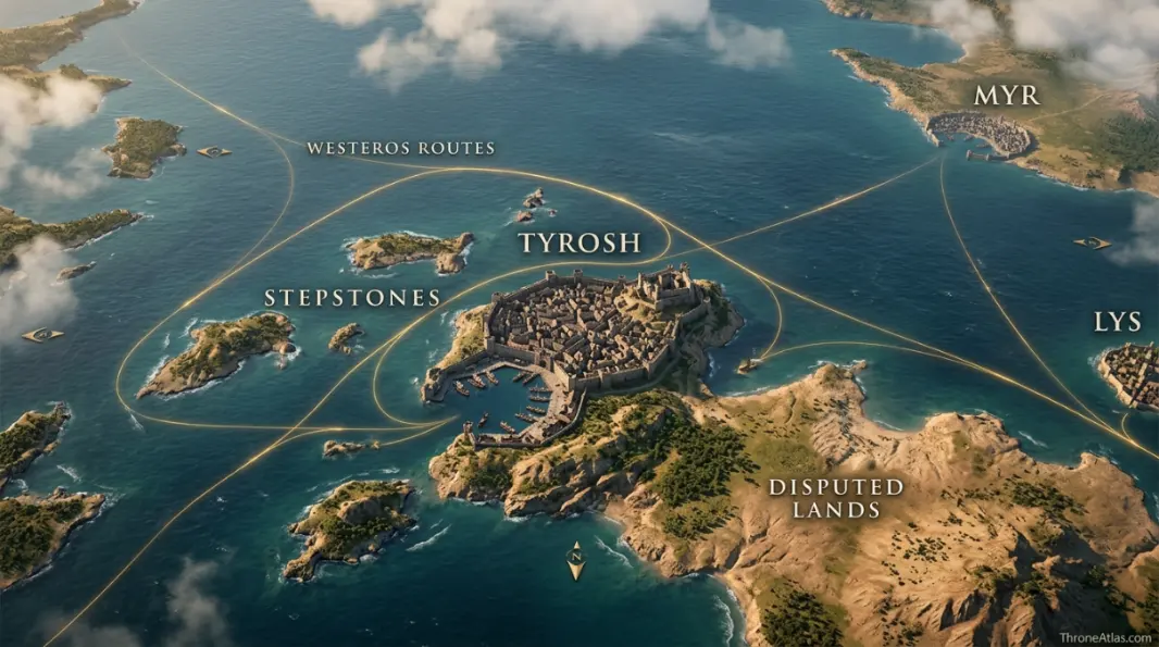
Tyrosh is an island Free City just north of the Stepstones and off the coast of the Disputed Lands. Its fortified harbor, Bleeding Tower and strategic position near shipping lanes explain why the city repeatedly competes with Lys and Myr and why it played a central role in the Triarchy. Tyrosh is a sea-control city first and a territorial power second.
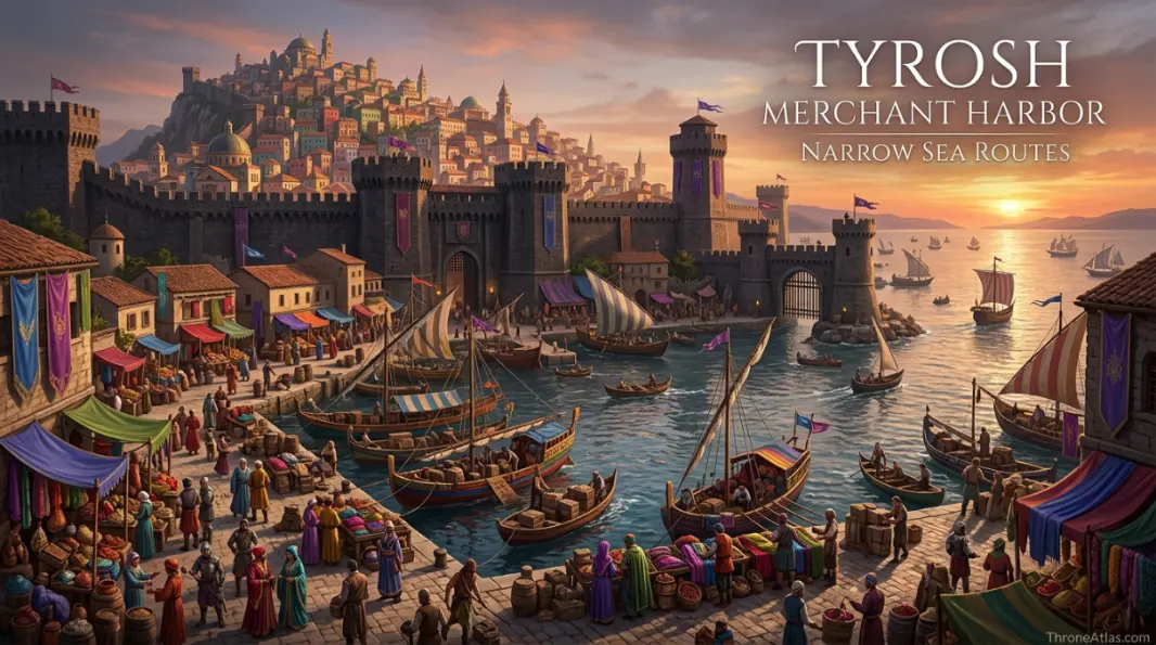
Tyrosh Map — Fortress Island at the Stepstones Gateway
Tyrosh began as a strategic outpost, and its position still reads like one: island walls, a defended harbor, the Stepstones nearby and the Disputed Lands just across the water.
Tyrosh, Bleeding Tower, Stepstones & Rival Cities
Tap a marker to reveal why that place matters. Marker positions are interpretive unless the canon confidence note says otherwise.
Canon Confidence & What This Map Claims
Tyrosh’s island setting, closeness to the Stepstones and Disputed Lands, fortified harbor and Bleeding Tower are strong anchors. Internal urban layout and exact maritime patrol routes remain schematic.
In This Guide
- Visual Atlas & Map
- Canon Confidence
- Map Index
- Where Is Tyrosh on the Map?
- The Bleeding Tower and Harbor: Defensive Geography
- Why the Stepstones Keep Pulling Tyrosh Into War
- Tyrosh, Lys and Myr: The Disputed Lands Triangle
- Tyroshi Trade, Dyes and the Merchant Identity
- Tyrosh in the Wider Game of Thrones World
- Cartographer Field Notes
- Direct Answers
- Source & Canon Basis
- FAQs
Tyrosh Map: What Defines the Fortress City
Tyrosh is a fortress island
Its original strategic role survives in the logic of the city’s geography.
The Stepstones are next door
That proximity pulls Tyrosh into piracy, tolls, naval wars and contested trade.
The Bleeding Tower guards the harbor
A landmark whose placement makes sense as part of maritime defense.
Myr and Lys are natural rivals
All three compete around the same southern land and sea zone.
Trade is prestigious
Tyrosh is mercantile as well as military, with famous dyes, armorsmiths and other commerce.
The Archon rules the city
Political authority is urban and oligarchic rather than feudal in the Westerosi sense.
The Triarchy amplified Tyroshi reach
Alliance with Myr and Lys turned local geography into regional naval power.
Sea control matters more than acreage
Tyrosh can affect wide routes without owning a vast mainland interior.
Places, Zones & Connections to Plot
| Place | Zone | Why It Matters | How to Read It on the Map |
|---|---|---|---|
| Tyrosh | Island north of Stepstones | Fortified Free City and maritime-commercial hub. | Center the map on the harbor and surrounding sea approaches. |
| Bleeding Tower | Harbor mouth | Prominent defensive landmark at the approach to the city. | Read it as a gatekeeper for ships entering the harbor. |
| Stepstones | Southwest / south | Island chain contested by pirates and regional powers. | Tyrosh’s proximity makes instability here an immediate concern. |
| Disputed Lands | East / northeast mainland | Long-contested zone involving Tyrosh, Lys and Myr. | Political influence shifts; do not draw a permanent Tyroshi border. |
| Lys | Southeast island | Rival and former Triarchy partner. | A close maritime competitor in the same southern system. |
| Myr | Northeast mainland | Rival with direct access to contested mainland territory. | The land-based corner of the three-city triangle. |
| Harbor | Tyrosh coast | Core of fleet, trade and city access. | The practical reason an island city can project power. |
| Narrow Sea routes | West / northwest | Connections toward Dorne, Westeros and broader shipping. | Explains Tyrosh’s relevance to stories that cross between continents. |
Where Is Tyrosh on the Map?
Tyrosh sits on an island just north of the Stepstones, off the southwestern coast of Essos and beside the Disputed Lands.
Few Free Cities have a position that explains their history so immediately. Put Tyrosh on a regional map and three facts appear at once: the Stepstones lie close by, the contested mainland is close by, and sea routes toward Westeros run past the wider area. The city was almost designed to care about shipping.
Its island status also changes the kind of power it can project. Roads are not the first question; ships are. A Tyroshi ruler concerned about trade, piracy or war can look outward from the harbor toward several theaters without possessing a huge continuous territory.
That position also explains why Tyrosh repeatedly appears in stories involving Daemon, Corlys, sellsails and the Stepstones: it is one of the nearest major city-states to the contested islands.
The Bleeding Tower and Harbor: Defensive Geography
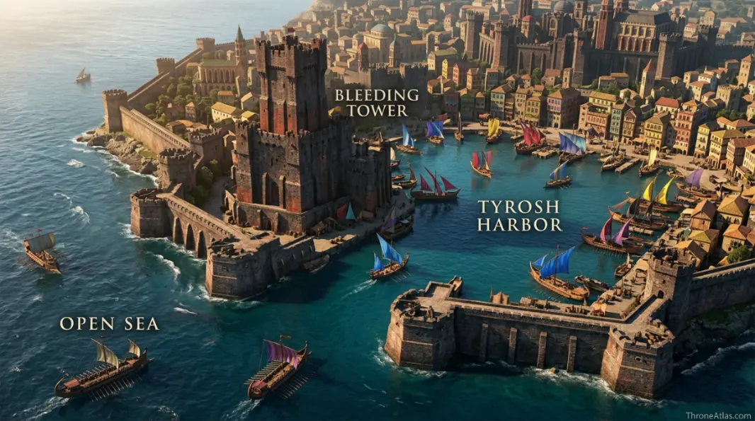
The Bleeding Tower stands at the mouth of Tyrosh’s harbor, turning a landmark into part of the city’s maritime defense and identity.
A city built around shipping lives or dies by its harbor. Tyrosh’s defenses therefore need to be read from the water inward. The Bleeding Tower is valuable on a map because it marks the transition between open sea and protected urban access.
The city’s high walls and Valyrian black-stone elements reinforce the fortress character. This is not a soft resort island. Its beauty, dyes and mercantile reputation exist alongside a military logic inherited from its origins as a Valyrian outpost meant to oversee strategic routes.
The harbor belongs at the center of any Tyrosh map because the city’s maritime orientation explains far more than an imagined maze of inner streets. Its defenses, commerce and regional rivalries all point back toward the water.
Why the Stepstones Keep Pulling Tyrosh Into War
Tyrosh sits so close to the Stepstones that piracy, tolls and military control there can directly affect its commerce and security.
The Stepstones are not empty dots between continents. They are a broken chain of islands through which important ships pass. When pirates become too strong, they can raise the cost of trade. When a coalition imposes tolls, commercial rivals notice. When a foreign prince establishes power there, nearby cities have to respond.
Tyrosh is especially exposed because distance is short enough for the islands to be part of its immediate strategic neighborhood. That does not mean permanent ownership; it means persistent interest. The city can send fleets, hire sellsails or join alliances because ignoring the Stepstones may be more expensive than intervening.
This is the geographic logic behind the Triarchy-era conflict. The battle map shows campaign events, while the Tyrosh page explains why this particular Free City was never going to treat the islands as somebody else’s remote problem.
Tyrosh, Lys and Myr: The Disputed Lands Triangle
Tyrosh competes with Lys and Myr because all three sit around the Disputed Lands and southern shipping network, producing repeated wars and temporary alliances.
From Tyrosh’s perspective, the conflict is two-directional. The mainland Disputed Lands lie to the east, while the Stepstones lie toward the west and south. That means land and sea rivalry overlap around the same city.
Myr’s mainland access and Lys’s island position produce different strengths, but all three can hire mercenaries and build fleets. The resulting balance is unstable. One campaign can produce an alliance; the next can reopen an old territorial claim.
The map should visualize this as a triangle rather than three isolated city articles. Users who land on Tyrosh can immediately understand why links to Lys, Myr and the Stepstones belong here semantically.
Tyroshi Trade, Dyes and the Merchant Identity
Tyrosh is famous for commerce, including distinctive dyes and high-quality arms and armor, so the city’s strategic location supports a culture where trade is a source of status.
The same harbor that launches fleets also receives merchants. That dual use is important: military infrastructure and commercial infrastructure are not separate worlds in a maritime city. Secure shipping can enrich the city, and wealth can finance stronger fleets.
Tyroshi dyes give the place a recognizable cultural signature, reflected even in descriptions of brightly colored hair and beards. This is more than trivia. It shows how local products can shape identity, reputation and character design far beyond the city itself.
A strong map page therefore keeps economy beside strategy. If the content only talks about war, it misses why the city cares so much about sea control in the first place. The harbor protects wealth as much as walls protect people.
Tyrosh in the Wider Game of Thrones World
Tyrosh enters the wider saga through sellswords, merchants, exiles, the Stepstones and characters whose identities travel between the Free Cities and Westeros.
Daario Naharis is often associated with Tyroshi culture in the books, and many other sellswords or sailors move through a world where city identity matters even after they leave home. The city therefore appears in the story’s social geography as well as the physical map.
Historically, Tyrosh is also close enough to Westeros to become involved in cross-sea politics. The Stepstones and Dorne create a geographic bridge between the two continents, making southern Free City conflicts harder for Westerosi powers to ignore than a distant war beyond Qarth.
Tyrosh matters because its geography ties together the Stepstones, the Disputed Lands and the southern Free Cities. It is a compact example of how one island city can influence shipping, mercenary warfare and politics across a much wider region.
How Each Marker Changes the Map
These notes are deliberately practical. They explain what each point does to movement, power, trade, defense, religion or social life instead of repeating a list of place names.
Tyrosh
On the atlas, Tyrosh should not be treated as an isolated pin. Its position in Island north of Stepstones matters because Fortified Free City and maritime-commercial hub.. The practical map-reading question is therefore Center the map on the harbor and surrounding sea approaches.. That relationship is more useful than pretending the world has modern surveyed coordinates.
Bleeding Tower
Bleeding Tower earns a place on this map for a different reason from a famous capital or battlefield. In Harbor mouth, Prominent defensive landmark at the approach to the city.. When following characters, fleets, merchants or armies, read this point through the lens of Read it as a gatekeeper for ships entering the harbor.; it explains what can realistically happen around it.
Stepstones
A good map gives Stepstones context, not just a label. Here the relevant geographic frame is Southwest / south. Island chain contested by pirates and regional powers.. For route and strategy purposes, the important takeaway is Tyrosh’s proximity makes instability here an immediate concern., which is why this location connects naturally to the surrounding markers.
Disputed Lands
The cartographic value of Disputed Lands comes from its relationship with the wider East / northeast mainland network. Long-contested zone involving Tyrosh, Lys and Myr.. In practical terms, Political influence shifts; do not draw a permanent Tyroshi border.. That makes the point meaningful even when the source material never provides exact mileage or a street-by-street survey.
Lys
On the atlas, Lys should not be treated as an isolated pin. Its position in Southeast island matters because Rival and former Triarchy partner.. The practical map-reading question is therefore A close maritime competitor in the same southern system.. That relationship is more useful than pretending the world has modern surveyed coordinates.
Myr
Myr earns a place on this map for a different reason from a famous capital or battlefield. In Northeast mainland, Rival with direct access to contested mainland territory.. When following characters, fleets, merchants or armies, read this point through the lens of The land-based corner of the three-city triangle.; it explains what can realistically happen around it.
Harbor
A good map gives Harbor context, not just a label. Here the relevant geographic frame is Tyrosh coast. Core of fleet, trade and city access.. For route and strategy purposes, the important takeaway is The practical reason an island city can project power., which is why this location connects naturally to the surrounding markers.
Narrow Sea routes
The cartographic value of Narrow Sea routes comes from its relationship with the wider West / northwest network. Connections toward Dorne, Westeros and broader shipping.. In practical terms, Explains Tyrosh’s relevance to stories that cross between continents.. That makes the point meaningful even when the source material never provides exact mileage or a street-by-street survey.
Fast Answers About the Map
On an island just north of the Stepstones, off the southwestern coast of Essos beside the Disputed Lands.
Yes. Tyrosh is one of the Nine Free Cities.
A prominent tower at the mouth of Tyrosh’s harbor associated with maritime defense.
Because the islands sit close to major shipping routes and instability there can directly affect Tyroshi trade and security.
Lys and Myr are its traditional rivals around the Disputed Lands and southern routes.
Yes. Tyrosh allied with Lys and Myr in the Triarchy.
What This Atlas Is Based On
Tyrosh is one of the clearest examples of geography shaping political behavior: the city is positioned to care about the same sea lanes and contested zones generation after generation.
- Fire & Blood: Triarchy, Stepstones and Tyroshi political history during the Dance-era prelude.
- The World of Ice & Fire: Valyrian origins, city government, trade and regional relationships.
- A Song of Ice and Fire: Tyroshi characters, cultural details, sellswords and wider Free City references.
- Published Free Cities maps: Used to anchor Tyrosh relative to Stepstones, Disputed Lands, Lys and Myr.
Continue Exploring ThroneAtlas Maps
Tyrosh Map FAQs
Where is Tyrosh in Game of Thrones?
Tyrosh is an island Free City just north of the Stepstones and off the coast of the Disputed Lands in southwestern Essos.
Is Tyrosh close to Dorne?
It lies across the Stepstones and Narrow Sea system from southern Westeros, making it much closer to Dorne than northern Free Cities such as Braavos.
What is Tyrosh famous for?
Its harbor, trade, dyes, skilled armorsmiths, colorful culture, sellsails and political rivalry with nearby Free Cities.
What is the Bleeding Tower?
A landmark at the mouth of Tyrosh’s harbor that helps define the city’s defended maritime approach.
Did Valyria found Tyrosh?
Tyrosh began as a Valyrian military outpost intended to help control strategic shipping and later developed into a major mercantile city.
Why did Tyrosh fight over the Disputed Lands?
The city competes with nearby Myr and Lys for influence over the same valuable mainland and regional trade system.
What was the Triarchy?
An alliance of Tyrosh, Lys and Myr that became a powerful regional coalition and fought for control around the Stepstones.
Is Tyrosh an island?
Yes. The city-state is based on an island at the northeastern side of the Stepstones region.
How is Tyrosh connected to House of the Dragon?
Its role in the Triarchy places it inside the political system behind the Stepstones war involving Daemon Targaryen and Corlys Velaryon.
Is this a precise city street map?
No. Major regional and harbor relationships are canon-based, while unrecorded internal streets are not fabricated as official geography.
Why Relative Geography Matters Here
Fantasy geography is most useful when it answers practical story questions: what lies between two places, which route is exposed, where control changes hands, how terrain changes travel, and why a location becomes politically valuable. For Tyrosh, those relationships matter more than an invented exact coordinate for every street or tower.
The interactive navigator complements the visual atlas by keeping the key locations readable and explaining why each marker matters to Tyrosh’s maritime geography.
The surrounding atlas links connect Tyrosh directly with the Stepstones, Essos, Daemon Targaryen and Corlys Velaryon, making it easy to follow the same geography from city scale to campaign scale.
Tyrosh Is a Harbor Looking at Two Frontiers
Tyrosh faces two strategic directions at once: the Stepstones at sea and the Disputed Lands on the nearby mainland. Its fortified harbor, Bleeding Tower, trade culture and rivalry with Lys and Myr all grow naturally from that position. The map therefore explains not only where Tyrosh is, but why it behaves like Tyrosh.