Volantis Map: Black Walls, Long Bridge, Rhoyne & City Districts
A city-scale atlas of the oldest Free City, built across the mouth of the Rhoyne: the Black Walls of Old Volantis, the crowded Long Bridge, western waterfront, R’hllor’s great temple and the trade routes that connect the city to the Summer Sea.
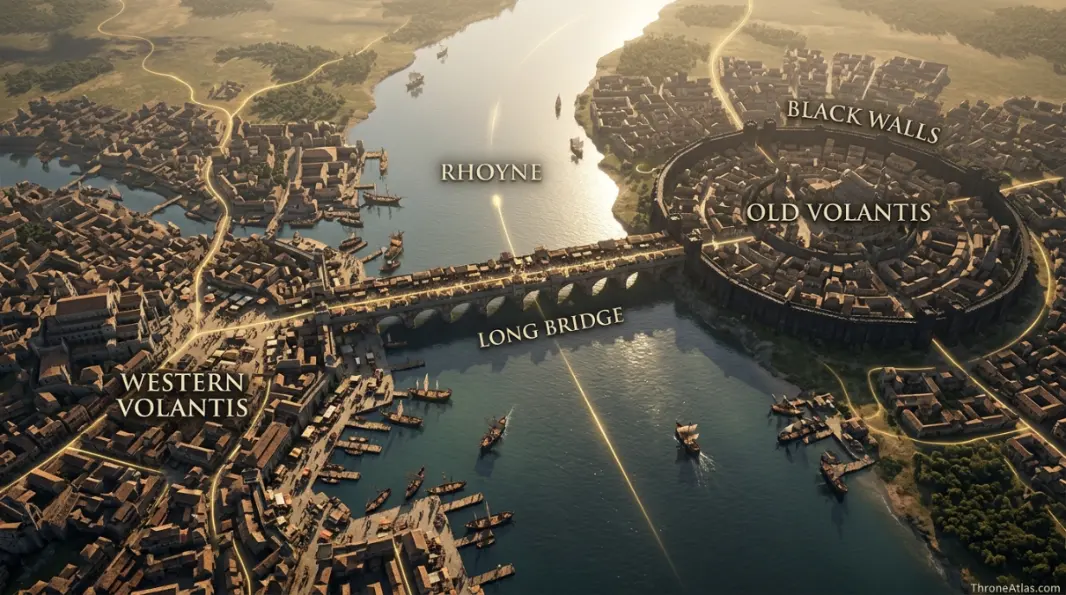
Volantis sits at the mouth of the Rhoyne on the southern coast of Essos. The older eastern city contains the Black Walls and elite Old Blood quarter; the newer western districts face busy waterfronts and foreign traffic. The Long Bridge crosses the river between them, making the city’s geography inseparable from class, commerce and the Rhoyne itself.
Volantis Map — River, Walls & Urban Power
Volantis is a city where the physical map is also a social map. The river divides, the bridge connects, and the Black Walls separate Old Blood privilege from the larger city around it.
Black Walls, Long Bridge & Waterfront
Tap a marker to reveal why that place matters. Marker positions are interpretive unless the canon confidence note says otherwise.
Canon Confidence & What This Map Claims
The east-west division of Volantis, the Rhoyne mouth, Black Walls and Long Bridge are firmly described. Exact modern-style street plans are not available, so district relationships are mapped without inventing a complete street grid.
In This Guide
- Visual Atlas & Map
- Canon Confidence
- Map Index
- Where Is Volantis on the Essos Map?
- The Rhoyne and Long Bridge: How Volantis Actually Works
- Inside the Black Walls: Old Blood and Built Geography
- Western Volantis: Waterfront, Foreigners and Everyday Movement
- Temple of the Lord of Light and the Religious Map of Volantis
- Why Volantis Matters to Daenerys, Tyrion and the Wider World
- Cartographer Field Notes
- Direct Answers
- Source & Canon Basis
- FAQs
Volantis Map: What Defines the City
The Rhoyne defines the city
Volantis spreads across both banks at the river mouth, making water the city’s organizing feature.
The east is older
Old Volantis lies mainly on the eastern bank and contains the Black Walls.
The Black Walls are social geography
Only the Old Blood may dwell within this ancient Valyrian enclosure.
The Long Bridge is the connector
The bridge links the two halves and functions as a dense commercial street in its own right.
The west receives outsiders
Foreigners and waterfront commerce are concentrated more heavily on the western side.
R’hllor is highly visible
The great Temple of the Lord of Light sits near the Black Walls and represents major religious power.
The harbor is continental infrastructure
Volantis connects Rhoyne traffic with the Summer Sea and routes toward Slaver’s Bay.
City size does not equal one center
Political, religious, mercantile and social power occupy different zones.
Places, Zones & Connections to Plot
| Place | Zone | Why It Matters | How to Read It on the Map |
|---|---|---|---|
| Black Walls | Eastern Volantis | Ancient Valyrian enclosure and residence of the Old Blood. | Treat as an internal border separating elite space from the wider city. |
| Long Bridge | Across the Rhoyne | Massive inhabited bridge linking east and west. | A movement choke point and commercial district at the same time. |
| Rhoyne | City center / river mouth | Great river dividing and feeding Volantis. | The city is organized around crossing and exploiting this waterway. |
| Old Volantis | East bank | Older, wealthier districts around the Black Walls. | Read as the historic elite heart rather than the whole city. |
| Western Volantis | West bank | Newer districts, waterfronts and heavy foreign traffic. | The practical arrival zone for many outsiders. |
| Temple of the Lord of Light | Near Black Walls | Huge R’hllor complex with major influence among slaves and freedmen. | Religious power sits physically close to elite political space. |
| Fishermonger’s Square | West bank | Busy commercial square associated with waterfront traffic. | Useful anchor for the crowded western city. |
| Merchant’s House | Western Volantis | Important inn used by travelers in the novels. | A story-scale waypoint inside the larger urban network. |
Where Is Volantis on the Essos Map?
Volantis lies in southern Essos where the Rhoyne reaches the Summer Sea, southeast of the other western Free Cities and west of Slaver’s Bay.
That position gives Volantis two kinds of reach at once. River traffic connects it northward into the Rhoyne basin, while sea traffic connects it west to the Free Cities and east toward Slaver’s Bay and beyond. A map that shows only the city walls misses the reason the city became powerful in the first place.
Volantis is also the southernmost of the Nine Free Cities and the closest major Free City to many of the routes that matter in Daenerys-era Essos. Political events in Slaver’s Bay therefore have economic and ideological consequences here even when Daenerys herself is not standing inside the city.
The macro map should place Volantis as a hinge between western and eastern story geography. Pentos and Braavos pull readers toward Westeros; Volantis pulls the Free Cities system toward the Rhoyne, Summer Sea and old Valyrian world.
The Rhoyne and Long Bridge: How Volantis Actually Works
The Rhoyne splits Volantis into eastern and western halves, and the Long Bridge turns that division into a controlled, crowded connection packed with shops, traffic and social friction.
A bridge is normally drawn as a simple line. Here that would be misleading. The Long Bridge is an inhabited urban corridor: buildings, commerce and constant movement turn the crossing into a district of its own. Anyone traveling between the city’s two halves has to think about that bottleneck.
The river itself is equally important. Upstream lies the enormous Rhoyne world; downstream is the Summer Sea. Goods, people and information can therefore enter from two transport systems. This is why Volantis feels broader than a normal coastal port. It is both a harbor city and a river city.
For map readers, the practical lesson is to orient everything around the river first. Once east, west and bridge are fixed, landmarks such as the Black Walls, Temple of the Lord of Light and western squares become much easier to place relative to one another.
Inside the Black Walls: Old Blood and Built Geography
The Black Walls enclose the ancient elite heart of Volantis, and residency within them is restricted to the Old Blood, turning architecture into a literal boundary of class and ancestry.
Few places in the known world make social hierarchy so visible on a map. The Black Walls are not simply fortifications against an outside army. They draw a boundary inside the city around families who claim descent from old Valyria. That makes the enclosed district simultaneously historical monument, defensive work and political statement.
The fused black stone also ties Volantis materially to Valyrian power. Readers who know Dragonstone or Valyrian roads can recognize a broader architectural language: the old empire left physical infrastructure that continues to structure societies centuries after the Doom.
This matters for AEO-style questions about “where do the Old Blood live?” The answer is spatial, not just genealogical: within the Black Walls in eastern Volantis. The map makes that fact immediate and shows why outsiders and lower-status residents experience the city differently.
Western Volantis: Waterfront, Foreigners and Everyday Movement
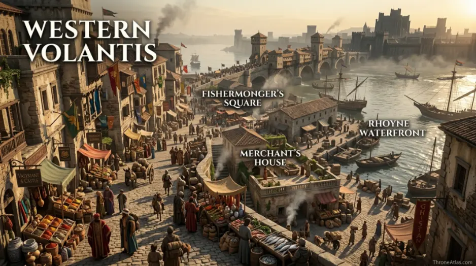
Western Volantis is the newer, busier side seen by many travelers, with waterfront commerce, crowded streets, squares and inns rather than the exclusive Old Blood enclave of the east.
Travel narratives often reveal cities from the edges inward. For Tyrion and other outsiders, western Volantis is where heat, traffic, smells, markets and social density become tangible. It is a useful counterweight to the monumental imagery of the Black Walls.
Fishermonger’s Square and the Merchant’s House provide story-scale anchors. They are not the most politically powerful places in Volantis, but they help readers understand how an individual moves through the city. That is exactly what a practical atlas should do: connect macro geography to lived route.
The west bank also reinforces the city’s economic openness. Foreign sailors and merchants can participate in Volantis without entering its most exclusive eastern spaces. Trade crosses social boundaries more easily than residency does, and the map makes that contradiction visible.
Temple of the Lord of Light and the Religious Map of Volantis
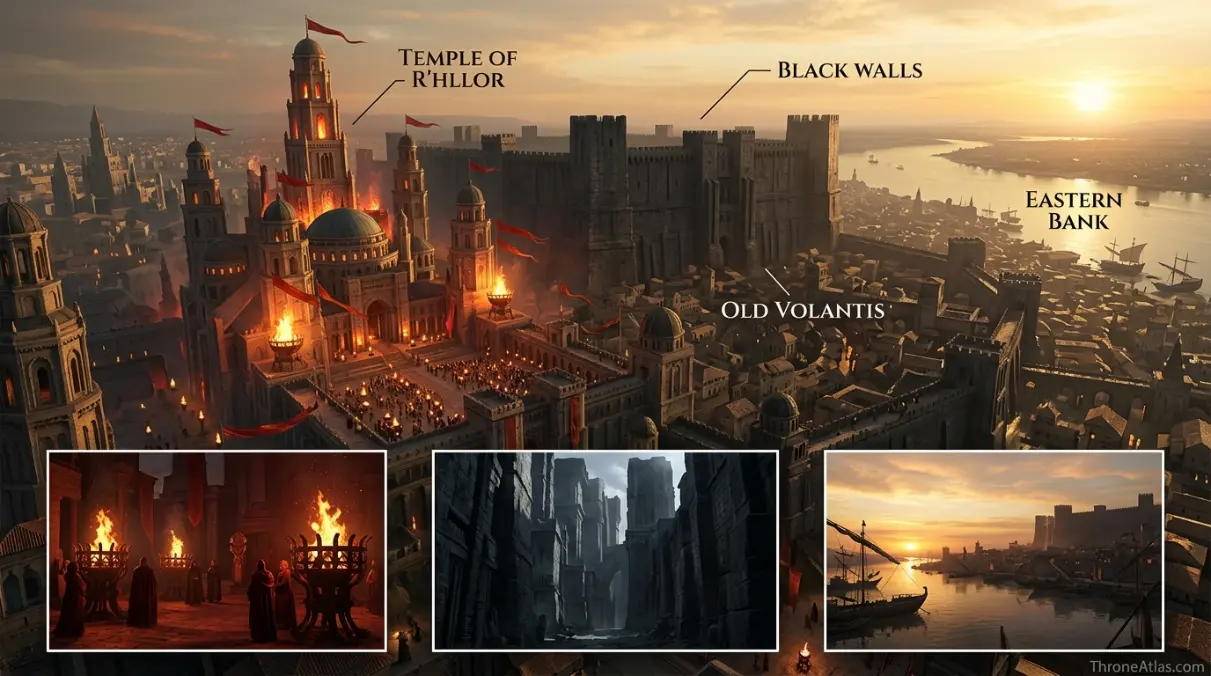
The Temple of the Lord of Light is one of Volantis’s major landmarks and sits near the Black Walls, placing a mass religious movement beside the physical center of Old Blood privilege.
Religious geography matters because R’hllor is not a private household faith here. The temple is monumental and socially visible, while red priests speak to large populations including slaves and freed people. Its location near elite space creates an especially sharp map of competing authority.
That tension becomes important in the later novels as Daenerys’s anti-slavery actions reverberate westward. A religious movement can interpret distant events as signs, while the Old Blood may view the same events through property, trade and political order. One city contains both reactions within walking distance.
A city guide that labels only “temple” and “walls” misses this deeper relationship. ThroneAtlas treats the markers as an ideological axis: old Valyrian aristocracy on one side, a powerful popular religion on the other, connected by the same streets and river system.
Why Volantis Matters to Daenerys, Tyrion and the Wider World
Volantis matters because it sits on routes used by major travelers and because its economy, religion and elite politics are directly affected by the upheaval Daenerys creates in the east.
Tyrion’s journey gives readers one of the clearest ground-level views of Volantis. His movement through the western side and awareness of the Black Walls turn a world-map label into a functioning city. The route also demonstrates how easily political news travels along merchant and river networks.
Daenerys exerts influence without immediately visiting. Her attack on slave systems changes expectations among enslaved people, religious leaders and elites elsewhere. On a political map, that is a powerful reminder that influence does not require occupation. A city can be destabilized by events hundreds of miles away if the same economic system connects them.
Volantis therefore deserves a dedicated page instead of one paragraph on the Free Cities hub. It is a layered city where river geography, Valyrian history, class segregation, slavery, religion and long-distance trade all occupy visible places on the same map.
How Each Marker Changes the Map
These notes are deliberately practical. They explain what each point does to movement, power, trade, defense, religion or social life instead of repeating a list of place names.
Black Walls
On the atlas, Black Walls should not be treated as an isolated pin. Its position in Eastern Volantis matters because Ancient Valyrian enclosure and residence of the Old Blood.. The practical map-reading question is therefore Treat as an internal border separating elite space from the wider city.. That relationship is more useful than pretending the world has modern surveyed coordinates.
Long Bridge
Long Bridge earns a place on this map for a different reason from a famous capital or battlefield. In Across the Rhoyne, Massive inhabited bridge linking east and west.. When following characters, fleets, merchants or armies, read this point through the lens of A movement choke point and commercial district at the same time.; it explains what can realistically happen around it.
Rhoyne
A good map gives Rhoyne context, not just a label. Here the relevant geographic frame is City center / river mouth. Great river dividing and feeding Volantis.. For route and strategy purposes, the important takeaway is The city is organized around crossing and exploiting this waterway., which is why this location connects naturally to the surrounding markers.
Old Volantis
The cartographic value of Old Volantis comes from its relationship with the wider East bank network. Older, wealthier districts around the Black Walls.. In practical terms, Read as the historic elite heart rather than the whole city.. That makes the point meaningful even when the source material never provides exact mileage or a street-by-street survey.
Western Volantis
On the atlas, Western Volantis should not be treated as an isolated pin. Its position in West bank matters because Newer districts, waterfronts and heavy foreign traffic.. The practical map-reading question is therefore The practical arrival zone for many outsiders.. That relationship is more useful than pretending the world has modern surveyed coordinates.
Temple of the Lord of Light
Temple of the Lord of Light earns a place on this map for a different reason from a famous capital or battlefield. In Near Black Walls, Huge R’hllor complex with major influence among slaves and freedmen.. When following characters, fleets, merchants or armies, read this point through the lens of Religious power sits physically close to elite political space.; it explains what can realistically happen around it.
Fishermonger’s Square
A good map gives Fishermonger’s Square context, not just a label. Here the relevant geographic frame is West bank. Busy commercial square associated with waterfront traffic.. For route and strategy purposes, the important takeaway is Useful anchor for the crowded western city., which is why this location connects naturally to the surrounding markers.
Merchant’s House
The cartographic value of Merchant’s House comes from its relationship with the wider Western Volantis network. Important inn used by travelers in the novels.. In practical terms, A story-scale waypoint inside the larger urban network.. That makes the point meaningful even when the source material never provides exact mileage or a street-by-street survey.
Fast Answers About the Map
At the mouth of the Rhoyne on the southern coast of Essos, where the river meets the Summer Sea.
A huge fused-stone enclosure around the oldest eastern district, where only the Old Blood may reside.
The great inhabited bridge crossing the Rhoyne and linking eastern and western Volantis.
The older elite districts are primarily on the eastern bank.
Foreign travelers are more commonly associated with the western side and waterfront districts.
Its river mouth, harbor, Valyrian heritage, large population, slavery-based economy and religious politics give it influence far beyond its walls.
What This Atlas Is Based On
Volantis has unusually rich book geography, allowing a more confident city layout than many fantasy locations while still stopping short of invented street precision.
- A Dance with Dragons: Tyrion’s route and detailed descriptions of the Rhoyne, Long Bridge, Black Walls, western districts and Volantene politics.
- The World of Ice & Fire: Founding history, Valyrian context, Free City politics and macro geography.
- Published Essos maps: Used for the relationship between Volantis, the Rhoyne, Summer Sea and surrounding regions.
- HBO continuity: Kept separate when screen geography simplifies or omits book-specific detail.
Continue Exploring ThroneAtlas Maps
Volantis Map FAQs
Is Volantis one of the Free Cities?
Yes. Volantis is one of the Nine Free Cities and is traditionally described as the oldest of them.
What river runs through Volantis?
The Rhoyne reaches the sea at Volantis and divides the city into eastern and western halves.
Where are the Black Walls?
They stand in eastern Volantis around the ancient elite district associated with the Old Blood.
Can anyone live inside the Black Walls?
No. Residence inside the Black Walls is restricted to the Old Blood, families claiming descent from the old Valyrian settlers.
Is the Long Bridge just a bridge?
No. It is a huge urban crossing lined with buildings, shops and activity, functioning like a street and district as well as infrastructure.
Where is the Temple of the Lord of Light?
It is located near the Black Walls in eastern Volantis and is one of the city’s most significant religious landmarks.
Does Tyrion visit Volantis?
Yes in the novels. His route provides important descriptive geography for the city, especially western Volantis, the Long Bridge and views toward the old eastern heart.
Does Daenerys go to Volantis?
In the published novels to date, her influence reaches Volantis more strongly than her physical presence. Her actions in Slaver’s Bay affect political and religious expectations there.
Is Volantis close to Valyria?
It is west and north of the Valyrian peninsula but historically deeply tied to the Freehold, having begun as an early Valyrian colony and military-commercial outpost.
Is this a street-accurate Volantis map?
No official complete street survey exists. Major divisions and landmarks are canon-based; smaller urban relationships are shown schematically and labeled as such.
Volantis Is a River City Before It Is a Pin
The best way to understand Volantis is to start with the Rhoyne. The river divides east from west, the Long Bridge reconnects them, the Black Walls turn ancestry into built geography, the western waterfront opens the city to outsiders, and the great temple adds religious power beside elite Valyrian space. Those relationships are the real Volantis map.