Westerlands Map: Casterly Rock, Lannisport, Houses, Gold & Roads
A complete map-first guide to House Lannister’s western homeland—its fortress core, port economy, hill passes, bannermen, ruined rivals and the routes that connect Casterly Rock to the wars of central Westeros.
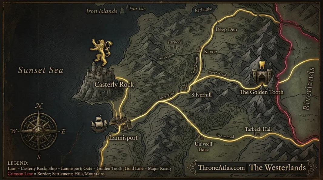
The Westerlands are the wealthy western region of Westeros centered on Casterly Rock and Lannisport. The Golden Tooth protects a key eastern approach from the Riverlands, while mineral wealth and a strong network of bannermen support House Lannister’s long dominance. The region’s strategic character comes from the combination of rugged hill country, defensible strongholds, coastal trade and resources that can be converted into military and political influence.
Westerlands Map at a Glance
This visual map is the fast geographic reference for the guide below. It is designed to show the places, routes, borders, strongholds or battle zones that matter most to this topic before you move into the deeper lore and strategy.
In This Guide
- Visual Map at a Glance
- What the Westerlands Map Actually Shows
- Casterly Rock: Fortress, Dynasty and Mineral Power
- Lannisport: The Urban and Maritime Counterpart to the Rock
- The Golden Tooth: Eastern Gate Toward the Riverlands
- Castamere and Tarbeck Hall: The Geography of Lannister Control
- Major Westerlands Houses Beyond the Lannisters
- Westerlands vs Riverlands: Why the Border Produces War
- Gold, Credit and the Political Reach of the Westerlands
- The Westerlands in Aegon’s Conquest
- How to Read a Westerlands Campaign Map
Westerlands Map: Casterly Rock, Lannisport, Houses, Gold & Roads: What Matters Most
Regional seat
Casterly Rock, ancestral fortress of House Lannister.
Major city
Lannisport provides trade, population and western maritime access.
Eastern gate
The Golden Tooth protects an important approach toward the Riverlands.
Historic wealth
The region is famous for gold and mineral resources.
Ruined rivals
Castamere and Tarbeck Hall preserve the memory of Tywin’s consolidation.
Bannerman network
Lefford, Marbrand, Crakehall, Westerling and other houses secure local territory.
War interface
The Riverlands border is a repeated campaign corridor.
Strategic balance
Wealth is powerful only when roads, castles, ports and loyal houses remain connected.
Places to Plot on the Map
| Location | Region / Zone | Why It Matters | Map Reading |
|---|---|---|---|
| Casterly Rock | West coast | House Lannister ancestral seat. | Fortress / dynastic center |
| Lannisport | West coast | Major city and harbor below the Rock. | Commercial / naval center |
| Golden Tooth | Eastern hills | House Lefford stronghold on eastern approach. | Gateway |
| Castamere | Westerlands | Ruined seat of House Reyne. | Historical warning |
| Tarbeck Hall | Westerlands | Destroyed Tarbeck seat. | Historical warning |
| Crakehall | Southwestern lands | House Crakehall seat. | Major bannerman |
| Ashemark | Westerlands | House Marbrand seat. | Bannerman / inland node |
| Riverlands frontier | East | Main land-war interface. | Campaign corridor |
What the Westerlands Map Actually Shows
The Westerlands map shows a wealthy, hilly western region centered on Casterly Rock and Lannisport, with the Golden Tooth guarding an important eastern approach. Mineral wealth, strong castles, coastal trade and House Lannister’s long political dominance make the region much more than a single gold-mine label.
The Westerlands occupy a compact strategic position compared with the enormous North or broad Reach. That compactness can be an advantage: major seats are closer to the core Lannister power base, roads can funnel through defensible hill country, and wealth can be concentrated around mines, ports and noble estates. Yet the region’s eastern frontier opens toward the Riverlands, making cross-border war a recurring concern.
Casterly Rock is the symbolic and geographic center. Lannisport turns the coast below it into an economic outlet. The Golden Tooth gives House Lefford a fortified approach through the hills. Farther south and inland, houses such as Crakehall, Marbrand and Westerling add local military and political capacity. Ruined Castamere and Tarbeck Hall preserve the memory of what happens when regional vassals challenge Lannister supremacy and lose.
For map readers, the key is to separate “wealth” into systems. Mines generate resources, ports turn resources into trade, roads move armies, and castles protect the network. Gold is powerful because geography and institutions let House Lannister convert it into soldiers, credit, marriage and influence.
Casterly Rock: Fortress, Dynasty and Mineral Power
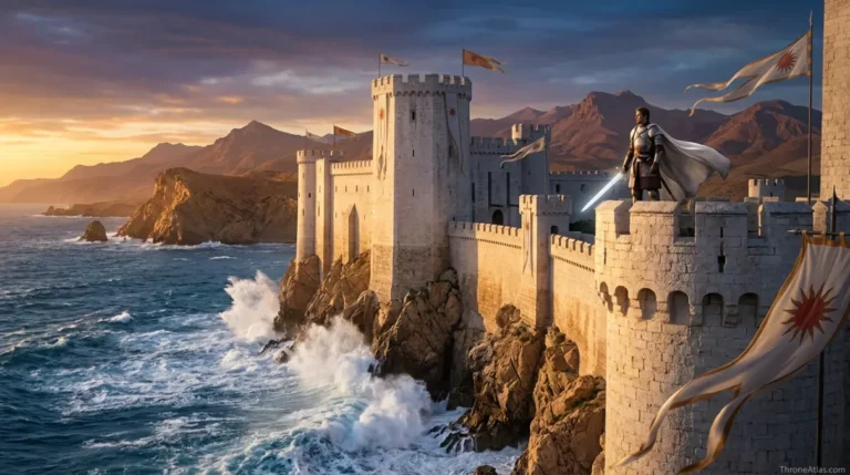
Casterly Rock is the ancestral seat of House Lannister, built into an enormous rocky promontory above the western coast. Its natural mass, internal spaces and association with nearby mineral wealth make it simultaneously a fortress, dynastic symbol and economic center.
Many Westerosi castles are fortifications placed on terrain. Casterly Rock is closer to terrain turned into a fortification. That distinction helps explain its legendary defensive reputation. An attacker is not merely facing walls but a giant natural formation shaped and occupied over generations.
The Rock also anchors Lannister identity in a way King’s Landing never can. Tywin may dominate the royal capital politically, but his family’s deep legitimacy comes from the west. This matters whenever national politics becomes unstable: the Westerlands provide a home power base independent of temporary offices at court.
Mineral wealth intensifies that independence. The exact condition of specific mines varies by book and television depiction, so a careful atlas should not flatten every continuity into the same claim. The broader historical fact is secure: the Westerlands are renowned for gold and other mineral resources, and Lannister wealth shapes politics across centuries.
Lannisport: The Urban and Maritime Counterpart to the Rock
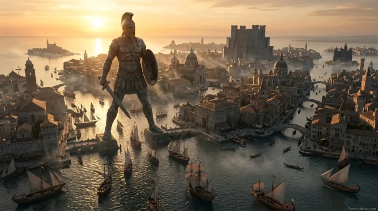
Lannisport lies on the coast near Casterly Rock and functions as the Westerlands’ major city and port. Where the Rock represents aristocratic fortress power, Lannisport represents population, trade, ships, crafts and the commercial activity needed to turn regional wealth into broader economic influence.
The proximity of castle and city creates a powerful pairing. A lord can defend from the Rock while benefiting from a large settlement and harbor nearby. Merchants do not need to climb into an impregnable fortress to move goods; the port gives the region an interface with the Sunset Sea.
That maritime exposure creates risk as well. During the Greyjoy Rebellion, Ironborn attacks on the Lannister fleet at Lannisport demonstrate that coastal wealth can attract enemies. A port is useful precisely because it is accessible, and accessibility always has a military downside.
On a Westerlands map, Lannisport should therefore be drawn as a separate major node rather than merged into Casterly Rock. They form one power cluster, but they perform different functions. The difference is comparable to a citadel beside a commercial city: physical proximity does not erase institutional specialization.
The Golden Tooth: Eastern Gate Toward the Riverlands
The Golden Tooth is a fortified position in the eastern Westerlands associated with House Lefford and important routes through the hills toward the Riverlands. Its value comes from controlling passage: armies moving between Lannister territory and river country have to think about the approaches it protects.
Mountain and hill passes turn geography into checkpoints. Even when alternative routes exist, a strong position can force an attacker to slow down, concentrate or reveal intentions. The Golden Tooth therefore matters more than its size might suggest on a continent map.
During wars with the Riverlands and northern forces, this eastern edge becomes the natural interface between Lannister home territory and the central battlefield. Tywin’s armies can move out through these approaches; enemies planning to invade the Westerlands have to solve the same terrain in reverse.
This is why regional maps need gateways. A border colored with a line can imply movement is equally easy everywhere. In reality, terrain creates preferred corridors. The Golden Tooth marks one of those corridors and helps explain campaign decisions around the western Riverlands.
Castamere and Tarbeck Hall: The Geography of Lannister Control
Castamere and Tarbeck Hall are remembered through Tywin Lannister’s destruction of Houses Reyne and Tarbeck. Their ruins turn the Westerlands map into a political warning: major vassal seats can become monuments to what happens when the regional center reasserts authority with overwhelming force.
The story of the Reynes matters because House Lannister’s dominance was not automatic in every generation. Wealthy bannermen can accumulate debts, castles and pride of their own. When the central house appears weak, local power centers may test the hierarchy.
Tywin’s response transforms geography into memory. Castamere becomes famous not for surviving as a rival center but for being erased. “The Rains of Castamere” then carries that geographic lesson beyond the region as a political threat. A song makes a ruined place portable.
On an atlas, ruins can be as important as active castles because they explain the current map. The absence of House Reyne is part of why the Westerlands look so thoroughly Lannister-dominated later. What appears to be stable unity was produced through historical conflict.
Major Westerlands Houses Beyond the Lannisters
Important Westerlands houses include Lefford, Marbrand, Crakehall, Westerling, Brax and others, each controlling local land, castles and military resources. House Lannister dominates the region, but effective rule depends on a network of bannermen who secure passes, roads, coast and agricultural districts.
The feudal system is spatial. A lord paramount cannot personally garrison every valley. Secondary houses convert local knowledge and inherited authority into regional control. Their loyalty lets Casterly Rock project power without placing Lannister soldiers in every settlement.
House Marbrand’s proximity to Lannister politics, House Lefford’s relationship to the Golden Tooth and House Crakehall’s southern position all demonstrate how geography assigns different functions. The Westerlings, meanwhile, become nationally important through Robb Stark’s story despite holding a seat far less famous than the Rock.
A good regional map should therefore use house territories as functional context rather than as trivia. Ask what road or frontier a house influences, what army it can join, and which neighboring region it faces. That is where heraldry becomes geography.
Westerlands vs Riverlands: Why the Border Produces War
The eastern Westerlands border opens toward the Riverlands, creating one of the saga’s most important military interfaces. Lannister forces can push east into fertile river country, while Stark-Tully armies can threaten westward approaches, turning passes, roads and castles into repeated campaign objectives.
The contrast between regions matters. The Westerlands are hillier and more naturally defensible around their core, while the Riverlands are more open and crossed by many rivers. That encourages Lannister commanders to fight aggressively in river country rather than waiting for enemies to reach the Rock.
During the War of the Five Kings, Tywin Lannister’s strategy devastates parts of the Riverlands while protecting access to his home resources. Robb Stark’s maneuvering then threatens the western flank and wins victories that show even a wealthy region can be penetrated when an opponent controls initiative and intelligence.
The border is therefore not a simple line between two colors. It is a zone where terrain changes and logistical priorities collide. Mapping the Golden Tooth, Riverrun and western river crossings together makes those campaigns far easier to understand.
Gold, Credit and the Political Reach of the Westerlands
The Westerlands’ economic importance extends far beyond the region because Lannister wealth can finance armies, influence royal debt and support alliances. Geography generates the resource base, but political power comes from converting that resource into obligations across the Seven Kingdoms.
Money moves differently from armies. A soldier has to cross a road; credit can reshape a decision hundreds of miles away. That is why economic geography deserves a place on a political atlas. Casterly Rock’s mineral reputation and accumulated wealth allow House Lannister to operate at the scale of the crown.
Tywin understands this conversion exceptionally well. Gold pays troops, supports royal ceremony, rewards allies and creates dependence. Marriage then turns economic leverage into dynastic leverage. The Westerlands can therefore influence King’s Landing without needing to relocate their physical resource base there.
Yet wealth is not invulnerability. Armies still require food, roads and competent commanders. Ports can be attacked. Mines cannot instantly solve a blocked pass. The most interesting map is one that shows how money interacts with those physical constraints rather than treating gold as magic.
The Westerlands in Aegon’s Conquest
Before the Targaryen conquest, House Lannister ruled the independent Kingdom of the Rock. King Loren I joined Mern IX Gardener of the Reach against Aegon, survived the Field of Fire and submitted, allowing the Lannister dynasty to retain Casterly Rock while losing its royal crown.
This history explains why Lannister identity is older than the Iron Throne. Their regional legitimacy does not come from Targaryen appointment in the same way House Tyrell’s lord-paramount status does. They were kings before Aegon and remained the obvious rulers of the west after submission.
The Field of Fire also reveals the limits of traditional strategic advantage. The combined Lannister-Gardener army has enormous manpower, yet massing soldiers on open ground creates a target for dragons. Loren’s survival lets Aegon use continuity rather than replace another dynasty.
Afterward, the Westerlands become integrated into the united realm without losing their distinct center. Casterly Rock is not replaced by King’s Landing; it becomes one of the great regional pillars beneath it. That old autonomy helps explain why later Lannisters can imagine themselves as partners, creditors or rivals of kings rather than merely servants.
How to Read a Westerlands Campaign Map
Read a Westerlands campaign map from east to west: first identify Riverlands approaches and the Golden Tooth, then trace roads toward Casterly Rock and Lannisport, and finally add secondary house seats and coastal access. This reveals defensive depth and explains why threatening the Lannister heartland requires more than crossing a political border.
The home region is compact enough that defenders can potentially concentrate faster than in the North, but terrain still channels movement. An invading army that gets through one approach has not automatically reached the Rock. Supply has to follow through hostile hill country, and local bannermen can threaten flanks.
Naval movement adds a separate layer. Lannisport and the western coast create opportunities for Ironborn-style raids that bypass eastern land defenses. The Westerlands therefore have two strategic faces: a fortified inland approach and an economically valuable coastline.
This duality is the best summary of the region. It is rich but exposed, compact but rugged, dominated by one dynasty but supported by many houses. The map explains how those apparent contradictions coexist.
Fortresses, Passes and Lannister Power

Continue Exploring ThroneAtlas
Westerlands Map: Casterly Rock, Lannisport, Houses, Gold & Roads: FAQs
Where are the Westerlands?
The Westerlands occupy the western side of central-southern Westeros along the Sunset Sea. They lie west of the Riverlands and north of parts of the Reach, with Casterly Rock and Lannisport forming the main power cluster.
Who rules the Westerlands?
House Lannister rules from Casterly Rock. The family were Kings of the Rock before Aegon’s Conquest and retained regional dominance after submitting to the Targaryens.
Is Casterly Rock the same as Lannisport?
No. Casterly Rock is the Lannister fortress and dynastic seat, while Lannisport is a major nearby coastal city and harbor. They form one strategic cluster but perform different political and economic functions.
Where is the Golden Tooth?
It lies on an important eastern approach through the Westerlands hills toward the Riverlands and is associated with House Lefford. Its position makes it strategically valuable during cross-border campaigns.
Why are the Westerlands rich?
The region is historically famous for gold and other mineral wealth, while Lannisport adds trade and urban commerce. House Lannister converts that resource base into armies, credit, alliances and influence at court.
Did the Lannister gold mines run dry?
Television dialogue and book material should not be flattened into one universal claim about every mine. The safe broader statement is that Westerlands mineral wealth is historically foundational to Lannister power; specific mine conditions vary by continuity and period.
What happened at Castamere?
Tywin Lannister destroyed House Reyne after rebellion, and Castamere became a ruin remembered through The Rains of Castamere. The event re-established fear of Lannister authority throughout the Westerlands.
What houses serve the Lannisters?
Major Westerlands houses include Lefford, Marbrand, Crakehall, Westerling, Brax and others. Their local castles and levies help House Lannister control a region that cannot be governed directly from the Rock alone.
Why does the Riverlands border matter?
It is the main eastern interface between Lannister home territory and central Westeros. Campaigns often move through passes and roads near this frontier during the War of the Five Kings.
Was the Westerlands independent before Aegon?
Yes. It was the Kingdom of the Rock under House Lannister. King Loren I fought Aegon alongside the Reach, survived the Field of Fire and submitted, retaining his dynasty’s regional seat without its crown.
The Geography Behind the Story
The Westerlands are the wealthy western region of Westeros centered on Casterly Rock and Lannisport. The Golden Tooth protects a key eastern approach from the Riverlands, while mineral wealth and a strong network of bannermen support House Lannister’s long dominance. The region’s strategic character comes from the combination of rugged hill country, defensible strongholds, coastal trade and resources that can be converted into military and political influence. The deeper value of this page is not memorizing names. It is seeing how roads, rivers, coasts, castles, distance, food, dragons, armies, and old political borders determine what characters can realistically do next. That is the layer ThroneAtlas is built to make visible.