House Tarth Map: Evenfall Hall, Sapphire Isle & Stormlands Connections
An island-house atlas of Evenfall Hall, coastal approaches, highlands and the sea lanes that connect Brienne’s homeland to the wider Stormlands.
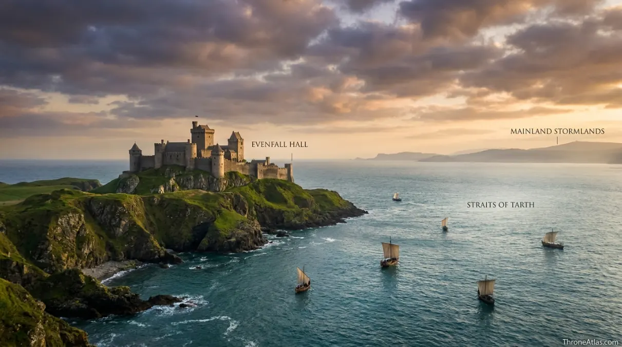
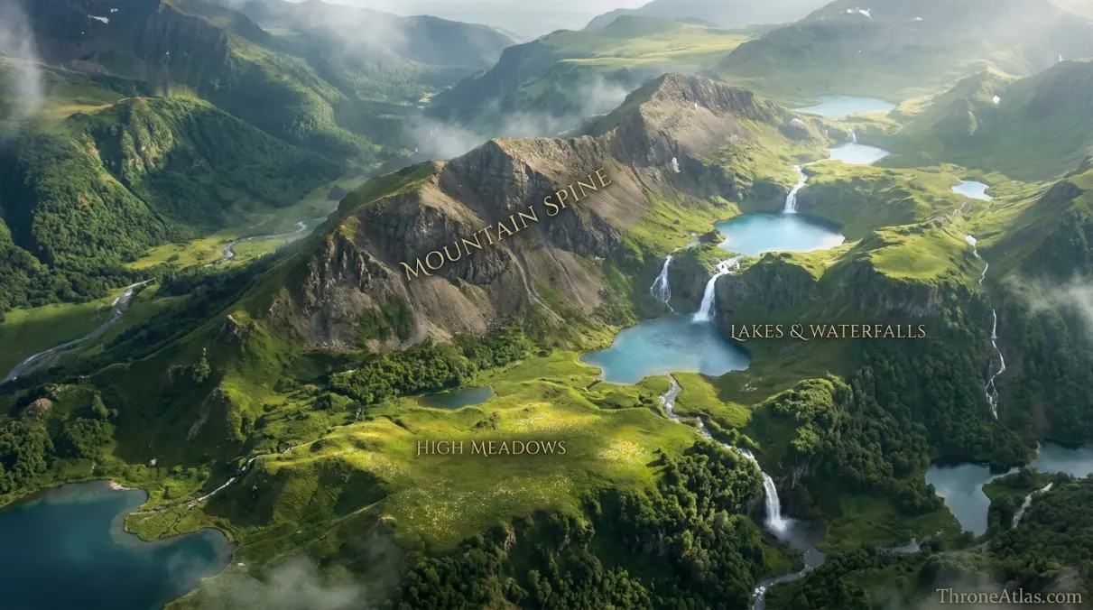
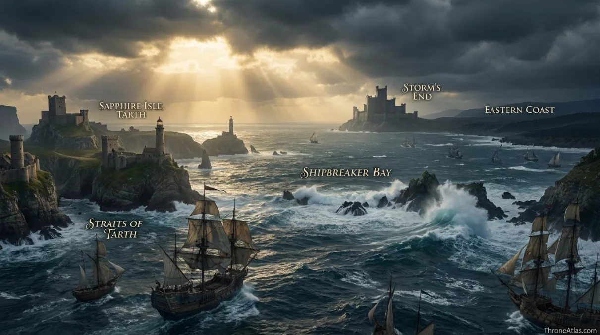
House Tarth rules the island of Tarth, known as the Sapphire Isle, in the Stormlands. Evenfall Hall stands on the western side of the island, across the Straits of Tarth from the mainland. The island lies near Shipbreaker Bay and is known for mountains, valleys, lakes, waterfalls and high meadows.
Map the House by Mapping the Island
House Tarth makes most sense at island scale. The atlas centers Evenfall Hall but also shows the Straits of Tarth, mountainous interior, eastern coast, Shipbreaker Bay and political connection to Storm’s End. These features explain why Tarth feels culturally connected to the Stormlands while remaining geographically distinct.
Canon Confidence & What This Map Claims
ThroneAtlas separates confirmed geography from useful reconstruction so a clean digital map never appears more certain than the underlying source.
Read the Map From Anchors to Story
- Visual Atlas
- Canon Confidence
- Key Takeaways
- Locations & Route Table
- An Island House Cannot Be Understood as a Castle Pin
- Evenfall Hall and the Logic of the Western Coast
- Mountains, Valleys, Lakes and the Interior of Tarth
- Straits, Shipbreaker Bay and the Maritime Stormlands
- Brienne’s Home Geography and Why It Matters to Her Story
- How Confidently Can the Sapphire Isle Be Drawn?
- Fast Answers
- Sources & Method
- FAQs
What the Sapphire Isle Adds to House Tarth
Evenfall Hall is only one anchor
The house seat matters, but the island around it explains House Tarth’s distinct identity.
The Straits create separation
Water physically distinguishes Tarth from mainland Stormlands castles while preserving sea access.
Mountains dominate the interior
High ground, valleys and upland meadows make the island more varied than a simple coastal outpost.
The western seat faces the mainland
Evenfall Hall’s position helps explain political and practical connection to the rest of the Stormlands.
Shipbreaker Bay frames the region
The dangerous waters around Storm’s End belong to the same maritime world as Tarth.
Brienne’s homeland is geographically meaningful
Her family identity comes from an island that is beautiful, remote and still tied to major mainland obligations.
House Tarth is sworn within the Stormlands order
Island geography does not imply political independence from Storm’s End.
Fine interior placement is approximate
The sources describe Tarth evocatively but do not provide a complete topographic survey.
Places, Routes & Strategic Connections
| Map Anchor | Type | Why It Matters |
|---|---|---|
| Evenfall Hall | Castle | The ancestral seat of House Tarth on the island’s western side, facing the mainland approaches. |
| Straits of Tarth | Water | The waters separating the Sapphire Isle from the mainland Stormlands. |
| Mountain Spine | Terrain | The island’s rugged interior high ground, represented as a broad terrain zone rather than a surveyed ridge. |
| High Meadows | Terrain | Upland pastoral country associated with Tarth’s scenic interior. |
| Lakes & Waterfalls | Terrain | A landscape zone reflecting the island’s famous freshwater scenery. |
| Eastern Coast | Coast | The seaward face of Tarth looking toward the narrow sea routes. |
| Shipbreaker Bay | Water | Dangerous waters near the Stormlands coast that frame Tarth’s broader maritime setting. |
| Storm’s End | Political | The Baratheon seat and principal political anchor on the nearby mainland. |
An Island House Cannot Be Understood as a Castle Pin
House pages often collapse a family into a single castle icon, but that approach works poorly for House Tarth. The family’s identity is inseparable from an entire island. Evenfall Hall is the seat, yet the Sapphire Isle supplies the distances, coastlines, high ground and maritime separation that make the house distinctive.
The island lies off the Stormlands and is separated from the mainland by the Straits of Tarth. That channel creates a meaningful geographic boundary. A rider cannot simply leave Evenfall Hall and join a mainland road; movement begins with water. Ships, landing places and weather therefore matter in a way they do not for an inland house.
At the same time, Tarth is not culturally detached from the Stormlands. Its rulers participate in the political order centered on Storm’s End, and the island sits close enough to the mainland to remain part of regional campaigns, marriages and noble obligations. The map therefore has to hold two truths together: Tarth is separated by sea, and Tarth is firmly connected to the Stormlands.
The island’s scenic reputation adds another layer. Mountains, meadows, lakes and waterfalls create a physical identity that contrasts with the harsher image many readers associate with storm-beaten coasts. “Sapphire Isle” is not merely a heraldic nickname. It evokes a landscape of striking water and color.
For Brienne of Tarth, this matters. Her origin is not a generic castle somewhere south of King’s Landing. She comes from a defined island world. Understanding that geography makes her departures, loyalties and repeated journeys across Westeros feel more substantial because the reader can see the home to which those journeys are anchored.
Evenfall Hall and the Logic of the Western Coast
Evenfall Hall stands as the political center of House Tarth, and its placement on the western side of the island is the first strong orientation point for a map. Facing the mainland side of Tarth makes practical sense for a noble seat that must remain connected to the Stormlands. Travel, messages and visitors from the mainland are easier to conceptualize when the seat is oriented toward the straits rather than isolated on the far seaward edge.
A castle on an island also performs different functions from one deep inland. It is a residence and fortified seat, but it is part of a maritime transport system. Boats and ships are not optional background details; they are the means by which people, supplies and political obligations cross the water.
The map therefore treats Evenfall Hall as the beginning of several relationships. West lies the strait and mainland Stormlands. South and southwest are the dangerous waters associated with Shipbreaker Bay. Inland rise the island’s hills and mountains. East lies the more open seaward coast. Each direction tells a different story.
The sources do not provide a room-by-room plan or a precise harbor chart for Evenfall Hall, so this atlas avoids turning the castle into an invented architectural diagram. The useful scale is broader. Where is the seat on the island? What waters separate it from the mainland? What terrain lies behind it? Which major mainland power anchors House Tarth’s feudal world?
Seen this way, Evenfall Hall is both remote and connected. Its walls belong to an island, but its western orientation keeps House Tarth facing the political world beyond the straits. That tension between separation and participation is one of the most important ideas the map can communicate.
Mountains, Valleys, Lakes and the Interior of Tarth
The interior of Tarth is unusually important because literary descriptions emphasize natural beauty rather than giving readers a dense list of towns and roads. The island is associated with mountains, hidden valleys, lakes, waterfalls and high meadows. Those descriptions create a clear topographic character even when they do not establish exact coordinates.
For mapping, the safest approach is to show terrain zones instead of drawing fictional mountain chains with invented names. A broad mountain spine can communicate that the island rises significantly inland. Meadow and freshwater zones can indicate the kinds of landscapes described without pretending a particular waterfall sits at an officially mapped latitude.
This matters because terrain affects movement. A mountainous interior concentrates easier travel along valleys, lower passes and coastal routes. It also creates visual separation between communities. An island may be small compared with a kingdom, yet rugged topography can make local journeys slower and more complicated than a flat map suggests.
The high meadows hint at productive land above the coast, while lakes and waterfalls suggest reliable freshwater. Those features help explain why Tarth can support a noble house and population rather than functioning as a barren military rock. The island’s beauty is part of its habitability.
For a reader following Brienne’s family background, this landscape also explains the emotional contrast between Tarth and many places she later encounters. War-torn Riverlands roads, muddy camps and ruined settlements are very different from the remembered beauty of the Sapphire Isle.
A map should preserve that contrast. Instead of filling the island with fabricated villages, ThroneAtlas emphasizes the physical categories the source actually gives us. The result is less superficially detailed but more trustworthy: a mountainous, green, freshwater-rich island framed by difficult seas.
Straits, Shipbreaker Bay and the Maritime Stormlands
Tarth belongs to a maritime region. The Straits of Tarth separate the island from the mainland, while the dangerous waters around Shipbreaker Bay help define the Stormlands coast more broadly. Anyone approaching or leaving the island has to think in terms of wind, sea conditions and coastal navigation.
Shipbreaker Bay has a fearsome reputation, and Storm’s End stands above that hostile seascape on the mainland. Tarth lies within the same broad weather system but is not identical to Storm’s End. The island’s own coastlines and straits create more sheltered and exposed approaches depending on direction.
This helps explain why House Tarth remains strategically relevant despite not controlling one of Westeros’s giant cities. Islands can watch sea lanes, provide anchorages, host local fleets and complicate hostile coastal movement. They are also harder for land armies to reach without ships.
The straits create a particularly useful map relationship. On a large Westeros map, the distance between Tarth and the mainland can look negligible. At local scale, that strip of water is the decisive fact. It determines how a messenger travels, how supplies arrive and how military force crosses between the island and continental Stormlands.
The nearby position of Storm’s End provides the political counterpart. House Tarth’s maritime geography does not remove it from regional feudal ties. The island still exists within the orbit of the Baratheon seat. When larger wars pull the Stormlands into competing royal claims, Tarth’s lords cannot treat the sea as a wall against politics.
That is why the atlas shows water with the same importance as land. For an island house, the sea is road, border and defense at once.
Brienne’s Home Geography and Why It Matters to Her Story
Brienne is the character through whom most readers develop an emotional relationship with Tarth. Yet her narrative spends relatively little time physically on the island. That makes a map valuable because it restores geographic substance to a home that is often remembered through identity, title and conversation rather than continuous on-page action.
“Brienne of Tarth” carries more meaning when Tarth is visible as an island. Every time she travels through the Reach, Riverlands or Crownlands, she is far from a home that requires a sea crossing to reach. Her loyalty to her father, her awareness of inheritance and the expectations placed on her all originate in a bounded place with its own noble history.
The contrast is especially strong during her journeys through the devastated Riverlands. There, roads are unsafe, villages are burned and political control is unstable. Tarth represents a different geographic memory: ordered lordship, natural beauty and an identifiable home seat. The map does not need to romanticize the island to make that contrast apparent.
Her family title also reminds readers that House Tarth is not a landless knightly line. It possesses a seat and territory with regional weight. Evenfall Hall, island terrain and maritime approaches provide the physical basis for that status.
At the same time, Brienne’s story demonstrates how noble identity travels beyond its home geography. She carries Tarth’s name into Renly Baratheon’s camp, Catelyn Stark’s service and later quests across Westeros. The island becomes portable through her.
A dedicated House Tarth map therefore supports both lore and character reading. It answers the simple question of where House Tarth is while also showing why the words “of Tarth” matter every time Brienne introduces herself.
How Confidently Can the Sapphire Isle Be Drawn?
Tarth is a good example of why fictional cartography needs levels of confidence. At regional scale, there is little ambiguity: the island is off the Stormlands coast, associated with the Straits of Tarth, and politically connected to Storm’s End. Evenfall Hall is the family seat on the island, and the interior is described as mountainous and beautiful.
At local topographic scale, the evidence becomes thinner. We know the kinds of landscapes present, but not the coordinates of every lake, meadow or waterfall. Drawing them as exact named points would create a false impression of source precision.
The same is true of roads. People clearly move across Tarth, but canon does not give readers a numbered road network with measured distances. A sensible atlas can infer that lower valleys and coastal approaches matter while refusing to invent a comprehensive highway map.
Adaptation imagery can help readers visualize atmosphere, but it should not automatically override book geography. Screen locations are selected for production needs, and a visual coastline on television is not necessarily a canonical survey of the island in the novels.
This page therefore uses stable anchors and descriptive terrain zones. Evenfall Hall, the straits, Shipbreaker Bay and mainland Stormlands provide strong orientation. Mountain, meadow and freshwater markers communicate landscape character while remaining openly schematic.
That method gives users something genuinely mappable without pretending we possess information George R. R. Martin never supplied. The result is a clearer answer to “where is House Tarth?” and a more honest answer to “what exactly does the island look like?” Those are different questions, and the atlas treats them differently.
Fast Answers About the Map
House Tarth rules the island of Tarth, the Sapphire Isle, off the coast of the Stormlands.
Evenfall Hall is the ancestral seat of House Tarth.
Yes. Politically, House Tarth belongs to the Stormlands and is connected to the power centered on Storm’s End.
The name is associated with the island’s striking natural beauty and blue waters.
The Straits of Tarth separate the island from the mainland Stormlands.
Yes. The island is described with mountains, valleys, high meadows, lakes and waterfalls.
It is associated with the western side of the island, facing toward the mainland approaches.
No. Their presence is canonical, but exact local coordinates are not fully supplied.
What This Atlas Is Based On
- George R. R. Martin’s A Song of Ice and Fire novels for House Tarth, Brienne’s identity and references to the island.
- The World of Ice & Fire and published reference material for Tarth’s place within the Stormlands and its landscape character.
- Published maps of Westeros for the island’s regional position relative to Storm’s End and the narrow sea.
- Interior terrain is shown as descriptive zones where exact local coordinates are not established.
Continue Exploring ThroneAtlas Maps
House Tarth Map FAQs
Where is Tarth on the map?
Tarth is an island off the Stormlands coast, separated from the mainland by the Straits of Tarth.
What castle does House Tarth rule from?
House Tarth rules from Evenfall Hall.
Is Brienne from Tarth?
Yes. Brienne is the daughter of Lord Selwyn Tarth and heir to the island’s ruling house.
Why is Tarth called the Sapphire Isle?
The name reflects the island’s celebrated beauty and the vivid blue waters surrounding it.
Is Tarth near Storm’s End?
It lies offshore from the Stormlands and within the political sphere associated with Storm’s End.
What is the landscape of Tarth like?
The island is described with mountains, hidden valleys, high meadows, lakes and waterfalls.
Can an army reach Tarth by road?
No. Because it is an island, a force must cross the surrounding water by ship or boat.
Does House Tarth control Shipbreaker Bay?
The island lies within the broader maritime geography near Shipbreaker Bay, but the bay is not simply the private possession of House Tarth.
Is the map based on the books or HBO?
The core geography is based on the written canon and published reference material, with adaptation imagery kept distinct where necessary.
Are the mountains and lakes shown at exact positions?
No. Their existence and general landscape character are established, while precise local placement is schematic.
Why This Geography Matters
House Tarth is best understood as an island system rather than a castle alone. Evenfall Hall anchors the western coast, rugged terrain shapes the interior, and the surrounding sea both separates the Sapphire Isle from the mainland and connects it to the political world of the Stormlands.