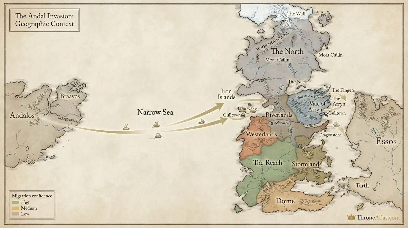
Andal Invasion Map
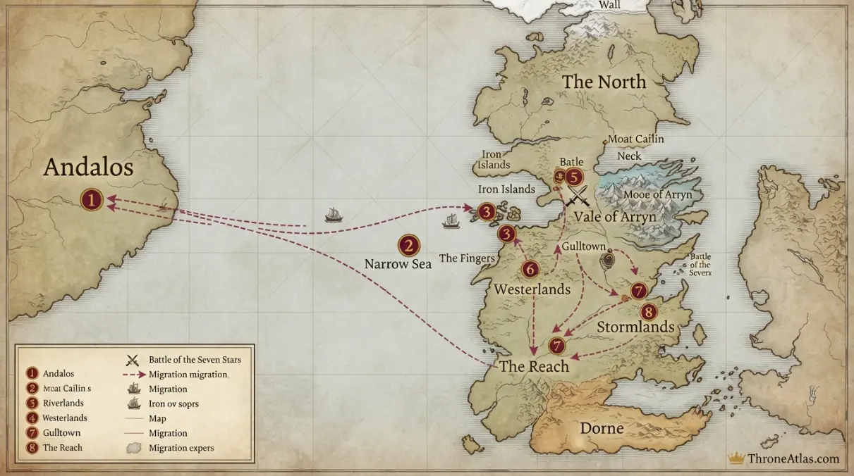
The Coming of the Andals was not a single invasion with one date and one army. It was a migration and series of wars stretching across generations. The first major Westerosi landings occur in the Fingers of the Vale, where Andal warlords fight and ally with First Men. Gulltown becomes an early foothold, and the decisive Battle of the Seven Stars establishes House Arryn’s dominance in the Vale. From there Andal culture, iron weapons, new dynasties and the Faith of the Seven spread through much of southern Westeros over centuries, while the North remains predominantly First Men.
Key Takeaways
Andalos / western Essos
This is an ancient-history atlas. Traditional geography can be mapped, but legendary dates and large-scale movements are presented with visibly softer precision than later historical wars.
Narrow Sea crossing, The Fingers and Gulltown
Confirmed anchors and reconstructed corridors are clearly separated.
The North frontier
Maintained for 2026.
Visual Atlas
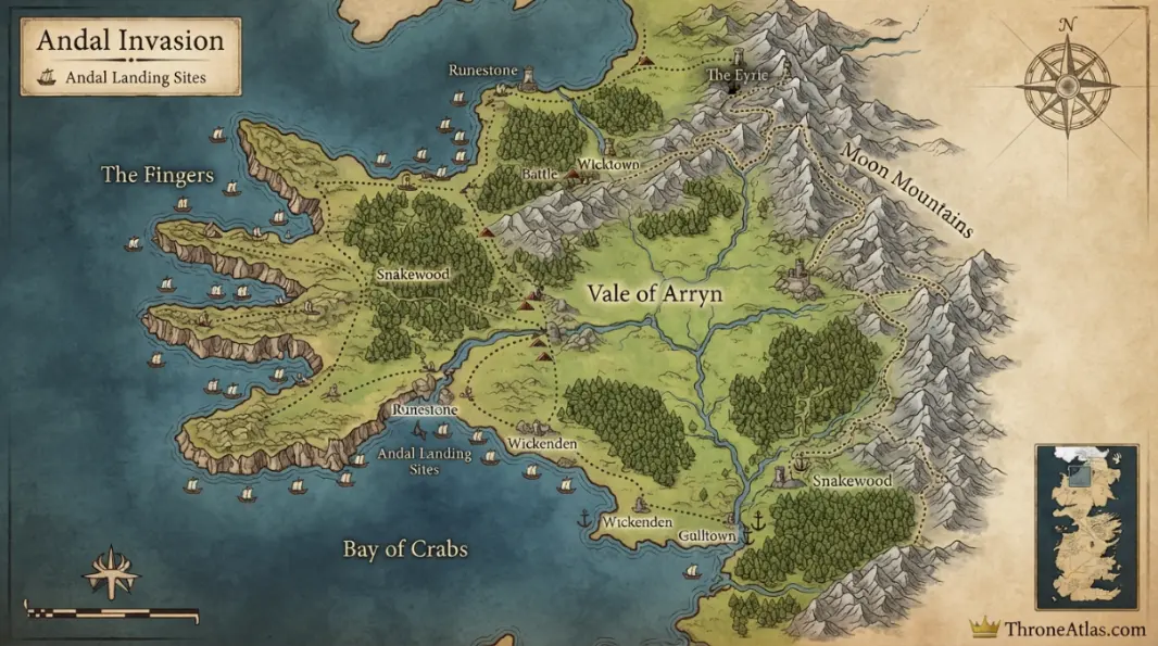
Each marker explains the geographic evidence behind the map.
Mapped Locations and Confidence
| Location / Phase | Confidence | Why it belongs on the map |
|---|---|---|
| 1. Andalos / western Essos | High | Andal tradition places the people’s origin in the hills of Andalos on the western side of Essos. |
| 2. Narrow Sea crossing | High | Andal groups cross west toward Westeros in waves rather than as one unified fleet. |
| 3. The Fingers | High | The Fingers in the Vale are identified as the first major landing zone where Andals wrest land from First Men. |
| 4. Gulltown | High | Alliances and conflict around Gulltown create an early Andal-controlled urban foothold. |
| 5. Battle of the Seven Stars zone | High | The decisive Vale battle breaks major First Men resistance and establishes Arryn dominance. |
| 6. Vale of Arryn | High | The Vale becomes the first great kingdom thoroughly associated with Andal rule and culture. |
| 7. Southern Westeros spread | High | Andal houses and the Faith spread into riverlands, westerlands, stormlands and Reach through generations of wars and marriages. |
| 8. The North frontier | High | Andal expansion largely fails to erase First Men dominance north of the Neck, leaving the North culturally distinct. |
1. Andalos / western Essos
Andal tradition places the people’s origin in the hills of Andalos on the western side of Essos. This marker is included because it fixes a major phase of the story to a real geographic relationship. It should be read with the surrounding points so that sequence, terrain and political context remain visible together.
2. Narrow Sea crossing
Andal groups cross west toward Westeros in waves rather than as one unified fleet. This marker is included because it fixes a major phase of the story to a real geographic relationship. It should be read with the surrounding points so that sequence, terrain and political context remain visible together.
3. The Fingers
The Fingers in the Vale are identified as the first major landing zone where Andals wrest land from First Men. This marker is included because it fixes a major phase of the story to a real geographic relationship. It should be read with the surrounding points so that sequence, terrain and political context remain visible together.
4. Gulltown
Alliances and conflict around Gulltown create an early Andal-controlled urban foothold. This marker is included because it fixes a major phase of the story to a real geographic relationship. It should be read with the surrounding points so that sequence, terrain and political context remain visible together.
5. Battle of the Seven Stars zone
The decisive Vale battle breaks major First Men resistance and establishes Arryn dominance. This marker is included because it fixes a major phase of the story to a real geographic relationship. It should be read with the surrounding points so that sequence, terrain and political context remain visible together.
6. Vale of Arryn
The Vale becomes the first great kingdom thoroughly associated with Andal rule and culture. This marker is included because it fixes a major phase of the story to a real geographic relationship. It should be read with the surrounding points so that sequence, terrain and political context remain visible together.
7. Southern Westeros spread
Andal houses and the Faith spread into riverlands, westerlands, stormlands and Reach through generations of wars and marriages. This marker is included because it fixes a major phase of the story to a real geographic relationship. It should be read with the surrounding points so that sequence, terrain and political context remain visible together.
8. The North frontier
Andal expansion largely fails to erase First Men dominance north of the Neck, leaving the North culturally distinct. This marker is included because it fixes a major phase of the story to a real geographic relationship. It should be read with the surrounding points so that sequence, terrain and political context remain visible together.
Why ‘invasion’ can be misleading
The Andals do invade, conquer and replace ruling lines, but the process spans generations and includes migration, alliance, intermarriage and local wars. A single arrow sweeping across Westeros would make the event look faster and more centralized than the histories describe.
The Fingers are the first map anchor
The rugged Fingers on the Vale coast are the classic starting point of Andal expansion in Westeros. The landscape gives newcomers landing places while the fragmented First Men politics of the Vale creates opportunities for alliance and conquest.
Gulltown shows how alliances matter
The Andals do not defeat every First Men house immediately. Some local rulers ally with newcomers against rivals. Gulltown becomes a vivid example of conquest working through political partnership as well as force.
Seven Stars changes the Vale
The Battle of the Seven Stars is the decisive military turning point in the Vale. After Robar II Royce’s defeat, House Arryn emerges as the dominant royal house.
Spread beyond the Vale takes centuries
Andal culture moves into other kingdoms through many separate conflicts. Roads, rivers, marriage networks and local dynasties matter more than one universal invasion route.
Why the North remains different
The Neck and Moat Cailin create a formidable geographic barrier. The North retains stronger First Men identity, old-gods worship and different noble traditions even after the Andals dominate much of southern Westeros.
Ancient chronology is intentionally soft
Maesters, legends and later historians do not agree on every date in the Dawn Age or early migrations. The map therefore gives more weight to sequence and geographic relationships than to a falsely exact year-by-year timeline.
Routes survive in cultural memory
Even where dates blur, stories preserve striking geographic anchors: a land bridge, an island, a great river, a mountain pass or a final landing place. Those anchors provide the strongest foundation for an ancient map.
Migration is not the same as conquest
Some movements involve invasion and settlement, others flight and refuge, and many contain both. The atlas explains purpose at each stage instead of giving every arrow the same meaning.
How to read the Andal Invasion Map
Start with Andalos / western Essos, locate Gulltown, and then zoom outward toward The North frontier. Those three anchors establish origin, turning point and wider consequence. They are not always a literal three-stop journey; on network and ancient-history pages they may instead represent changes in power, geography or certainty.
This is an ancient-history atlas. Traditional geography can be mapped, but legendary dates and large-scale movements are presented with visibly softer precision than later historical wars.
The central discipline is to keep physical geography separate from political interpretation. A river, castle or island can remain fixed while the people controlling it change. A hidden network can expand without moving a border. A migration can pass through a region without claiming it. The page uses that separation throughout.
Distance, movement and map scale
Fantasy maps often encourage straight-line thinking, but movement is rarely that simple. Armies must use passes and crossings. Ships respond to coastlines, weather and safe harbors. Migrants may divert for food, refuge or danger. Spies and messengers use social access as much as roads. Exact distance is therefore less useful than the sequence of reliable anchors unless the source provides specific measurements.
The visual atlas is schematic for the same reason. Its markers are designed to communicate order, connection and relative geography. The finished image source can carry richer terrain and regional artwork, but neither should imply GPS precision where the books do not provide it.
What changes when the map shifts scale
At close scale, Andalos / western Essos can dominate the story. Zooming out may reveal that the location is one node in a much larger system: Gulltown might connect it to a campaign corridor, religious network, migration route or political center. At the widest scale, The North frontier shows where that local story intersects the larger history of Westeros or Essos.
This multi-scale view is especially valuable for events spanning decades or centuries. The same mountain pass can appear in multiple wars. The same capital can host rival spy networks. The same coast can receive migrants from very different cultures. Geography becomes the stable layer that connects separate histories.
Confirmed fact, reconstruction and tradition
High-confidence markers are grounded in explicit place names, published maps or clear narrative relationships. Medium confidence means the broad location or connection is strong but not precise enough for a hard coordinate. Low confidence is used where the tradition itself is uncertain, especially in Dawn Age or semi-canon material.
That hierarchy is not a judgment about narrative importance. A legendary event can be culturally central while geographically uncertain. A minor river junction can be perfectly mapped while barely mentioned in the story. Keeping importance and confidence separate is essential for an honest atlas.
Fast atlas answers
Primary anchor
Andalos / western Essos is the strongest point for first orientation.
Key transition
Gulltown marks a meaningful shift in movement, power or conflict.
Outer consequence
The North frontier shows where the map reaches its final phase or widest connection.
Why geography changes the interpretation
The Coming of the Andals was not a single invasion with one date and one army. It was a migration and series of wars stretching across generations. The first major Westerosi landings occur in the Fingers of the Vale, where Andal warlords fight and ally with First Men. Gulltown becomes an early foothold, and the decisive Battle of the Seven Stars establishes House Arryn’s dominance in the Vale. From there Andal culture, iron weapons, new dynasties and the Faith of the Seven spread through much of southern Westeros over centuries, while the North remains predominantly First Men.
Once the places are seen together, the history becomes easier to interpret. A rapid conquest may look less secure when the deserts and passes beyond the captured capital are visible. A spy master’s influence may look broader when secret corridors connect offices and royal apartments. A migration may look less like a single heroic voyage when repeated failed refuges are plotted in sequence.
This is the main purpose of the page: not merely to add pins, but to let spatial relationships test the story. Geography can confirm a political strategy, expose the weakness of an occupation, explain why a road becomes a battlefield or show why a cultural migration cannot be reduced to one arrow.
Atlas field notes: time and control
Time is another layer that needs care. Historical pages often cover years or generations, and placing every phase on one static image can make simultaneous events look sequential or sequential events look simultaneous. The text and numbered markers therefore provide chronology alongside the visual map.
Control is equally temporary. Capturing Sunspear in one year, occupying Harrenhal in another, or holding King’s Landing under a new faction does not permanently recolor the geography. The atlas describes control inside the relevant phase rather than treating political possession as a timeless fact.
When the source record is fragmentary, restraint is part of the design. An unmarked stretch of sea, desert or road is not an error if the route is genuinely unknown. It is more accurate to preserve a gap than to turn a plausible guess into visual authority.
Using related maps for deeper context
The related pages below are chosen to change scale or perspective. Regional maps establish distance and terrain. Location maps add local detail. Character and battle maps show how the same place changes under different events. Reading them together creates a stronger atlas than asking one page to carry every layer at once.
That connected approach also protects topical clarity. Andal Invasion Map remains focused on its own geographic question while still giving readers direct paths into the wider world.
What to compare on the wider ThroneAtlas
Use the related maps to compare the same geography from another angle. A regional map answers scale; a city or castle map answers local placement; a character route adds movement; a battle page adds temporary control. The best geographic understanding comes from seeing those layers together without forcing them into one oversized graphic.
This page stays focused on its own subject so those connections remain clean. The goal is depth without duplication: enough context to understand the map, followed by direct pathways into the next layer of the atlas.
Map Accuracy and Canon Confidence
High confidence marks geography directly established in the published material. Medium confidence marks a strong regional reconstruction, planned route or less precise placement. Low confidence is reserved for legendary origins or unresolved coordinates.
ThroneAtlas does not add exact borders, hidden streets, migration tracks or march routes simply to make the graphic look complete. Where the record becomes uncertain, the atlas keeps that uncertainty visible.
Source Basis
This atlas follows the broad historical geography in The World of Ice & Fire. Dates for the Coming of the Andals are disputed within the setting, so the map emphasizes sequence and regional spread rather than a false exact timeline.
The page is an interpretive atlas built from established place relationships and historical sequence. It is designed to answer where events happen, how locations connect and how confidently each part can be mapped.
Frequently Asked Questions
Where does the Andal invasion map begin?
The first major anchor is Andalos / western Essos. The map then follows the strongest geographic or chronological relationships outward from that point.
What is the key turning point on the Andal invasion map?
Gulltown is one of the most useful turning points because it changes the route, conflict or political meaning of the map.
Is this Andal invasion map based on published canon?
Yes. Published history and mapped geography form the base. Semi-canon or uncertain details are labeled rather than presented with equal confidence.
Are all lines on the map exact routes?
No. Exact lines are used only where route evidence is strong. Long migrations, hidden networks and campaign marches are often better represented as corridors or zones.
What does High confidence mean?
High means the place or relationship is directly established by published geography or narrative. Medium indicates a strong reconstruction. Low marks genuine uncertainty.
Why does the map show nearby places that were not conquered or visited?
Nearby places can be necessary for orientation, strategy or political context. Their inclusion does not imply ownership, occupation or a confirmed personal visit.
Can this atlas be used for exact mileage?
No. It is designed for relative position, sequence, terrain and strategic relationships rather than modern survey measurements.
How does ThroneAtlas handle conflicting traditions?
The page keeps the strongest shared geographic facts and labels disagreements or legendary elements instead of choosing one uncertain version without warning.
What should I open next?
The Continue Exploring section links to the most useful regional, character, battle and location maps connected to the same geography.
When was this Andal invasion map updated?
This ThroneAtlas page is maintained as a 2026 edition and intentionally avoids a fixed day-and-month freshness stamp.