Crownlands Map: King’s Landing, Dragonstone, Driftmark, Houses & Roads
A complete atlas of the royal heartland around Blackwater Bay—mapping the capital, Targaryen islands, mainland supply ring, local houses and the routes that make control of the Iron Throne possible but never simple.
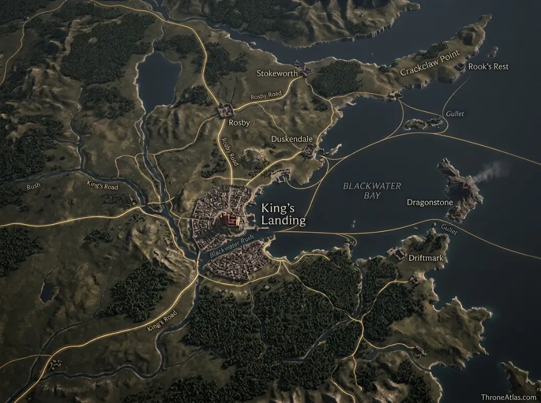
The Crownlands are the royal region around King’s Landing and Blackwater Bay. Unlike the old kingdoms, they were formed around Targaryen rule after Aegon’s Conquest. Their major strategic nodes include King’s Landing and the Red Keep, Dragonstone, Driftmark, Duskendale, Rosby, Stokeworth, Crackclaw Point and Rook’s Rest. The region is best understood as a capital-support network of roads, ports, islands and nearby houses rather than as one ancient kingdom with a single regional dynasty.
Crownlands Map at a Glance
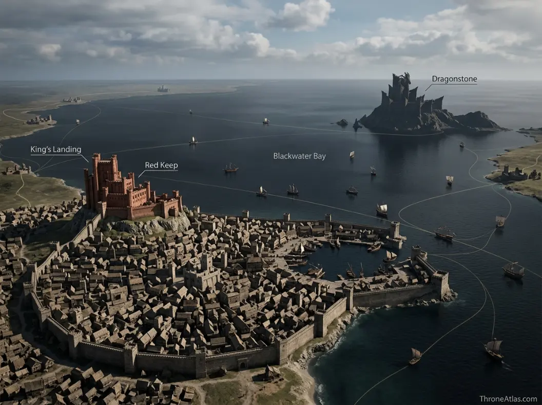
This visual map is the fast geographic reference for the guide below. It is designed to show the places, routes, borders, strongholds or battle zones that matter most to this topic before you move into the deeper lore and strategy.
In This Guide
- Visual Map at a Glance
- What the Crownlands Map Actually Shows
- King’s Landing: A Capital Built by Conquest
- The Red Keep and the Inner Geography of Royal Power
- Blackwater Bay: The Waterway That Makes and Threatens the Capital
- Dragonstone: Royal Island, Targaryen Base and Eastern Shield
- Driftmark and the Velaryon Maritime Network
- Duskendale, Rosby and Stokeworth: The Capital’s Near Neighbors
- Crackclaw Point and the Rough Eastern Mainland
- Rook’s Rest and the Crownlands as a Dragon Battlefield
- Why the Crownlands Were Created After Aegon’s Conquest
- How to Read Crownlands Control During Civil War
Crownlands Map: King’s Landing, Dragonstone, Driftmark, Houses & Roads: What Matters Most
Political center
King’s Landing and the Red Keep.
Historic origin
The region emerges around the Targaryen monarchy after the Conquest.
Maritime system
Blackwater Bay links the capital to Dragonstone, Driftmark and the Narrow Sea.
Royal island
Dragonstone predates the capital and can support a rival court.
Naval partner
Driftmark gives House Velaryon strategic fleet power.
Mainland ring
Duskendale, Rosby and Stokeworth add ports, food and road control near the capital.
Rugged edge
Crackclaw Point preserves local autonomy close to royal territory.
Civil-war rule
Never assume whoever holds King’s Landing controls every Crownlands node or sea lane.
Places to Plot on the Map
| Location | Region / Zone | Why It Matters | Map Reading |
|---|---|---|---|
| King’s Landing | Blackwater Bay | Capital and seat of Iron Throne. | Political center |
| Red Keep | King’s Landing | Royal fortress and council center. | Inner seat of power |
| Dragonstone | Outer bay / Narrow Sea | Ancient Targaryen island fortress. | Royal rival base |
| Driftmark | Narrow Sea islands | House Velaryon seat and maritime network. | Naval power |
| Blackwater Bay | Central waterway | Trade and invasion route into capital. | Maritime system |
| Duskendale | Mainland coast | Important Crownlands town and port. | Urban node |
| Rosby | Near capital | House and lands close to King’s Landing. | Supply / road node |
| Stokeworth | Near capital | Nearby noble seat. | Supply / road node |
| Crackclaw Point | Eastern mainland | Rugged peninsula with local houses. | Peripheral terrain |
| Rook’s Rest | Crownlands | Dance-era castle and dragon battle site. | Military node |
What the Crownlands Map Actually Shows
The Crownlands are the royal heartland around King’s Landing and Blackwater Bay, including nearby mainland houses, important roads and islands such as Dragonstone and Driftmark. Unlike most great regions, they are not the preserved territory of an ancient independent kingdom; they emerge around the Targaryen monarchy after Aegon’s Conquest.
That origin makes the Crownlands politically unique. The North has Stark memory, the Vale has Arryn kings, the Reach remembers Gardeners, and the Westerlands remember Lannister kingship. The Crownlands are built around a new royal center. Their identity is therefore tied more directly to the Iron Throne and the capital than to one pre-Conquest regional dynasty.
King’s Landing dominates the map because it concentrates population, government, royal institutions, trade and symbolic authority. Yet the city depends on surrounding systems. Blackwater Bay connects it to the Narrow Sea. Roads bring food from neighboring regions. Dragonstone controls a major island position offshore. Driftmark supports Velaryon maritime power. Rosby and Stokeworth sit close enough to the capital to matter to supply and defense. Duskendale provides another important town and port within the broader royal zone.
A Crownlands map should therefore be read as a capital-support network. Ask what feeds the city, what protects the bay, what islands can threaten or defend approaches, and which castles sit on roads an army must use. The answer reveals why controlling the Red Keep alone never guarantees control of the region.
King’s Landing: A Capital Built by Conquest
King’s Landing is the political center of the Crownlands and the Seven Kingdoms, founded around Aegon the Conqueror’s mainland foothold rather than inherited from an older royal dynasty. Its position on Blackwater Bay gives it trade access and naval importance while also making sea approaches a permanent strategic concern.
The city’s location is a political statement. Aegon does not rule from Winterfell, Highgarden or Casterly Rock, which would have made one conquered kingdom appear to dominate the new realm. He builds a new capital associated with Targaryen victory and a new administrative order.
Blackwater Bay lets the city connect to Dragonstone, Driftmark and wider Narrow Sea trade. That maritime access supports population growth, but it also exposes the capital to fleets. The Battle of Blackwater demonstrates the danger when Stannis Baratheon attacks by sea. Later Targaryen civil wars repeatedly make control of nearby waters crucial for the same reason.
The city’s enormous population creates another geographic dependency: food must flow inward. The Crownlands alone cannot be treated as a self-sufficient island around the throne. Reach grain, Riverlands roads and maritime commerce all affect political stability inside the walls.
The Red Keep and the Inner Geography of Royal Power
The Red Keep sits on Aegon’s High Hill above King’s Landing and functions as the physical seat of royal government. Within the wider Crownlands map it is tiny, but politically it concentrates the throne room, royal household, council spaces and defensive architecture that make control of the capital visible.
Political maps often place a crown icon over King’s Landing and stop there. Zooming in reveals that power is layered. A city can be occupied without every institution being secure, and the Red Keep can be held while streets outside become hostile. The fortress is therefore both center and bunker.
Maegor’s Holdfast, the throne room and castle gates create an inner map of authority. Access is controlled. Messages and people move through chokepoints. During coups, funerals, coronations and civil unrest, these short distances matter intensely because whoever reaches a room first may influence the entire realm.
For the Crownlands regional page, the Red Keep should be linked outward rather than treated as self-contained. Its decisions depend on Dragonstone, the bay, roads to Rosby and Stokeworth, and political events across Westeros. The castle is the command room; the region is the operating environment.
Blackwater Bay: The Waterway That Makes and Threatens the Capital
Blackwater Bay is the maritime basin east of King’s Landing connecting the capital to the Narrow Sea, Dragonstone and Driftmark. It supports trade and naval movement but also creates the most direct large-scale approach to the city, which is why fleets and island fortresses repeatedly shape Crownlands strategy.
The Battle of Blackwater makes this obvious in Game of Thrones. Stannis’s fleet tries to turn the bay into a highway for invasion. Wildfire, defenses and land forces then turn the same water into a killing zone. Geography provides opportunity to attacker and defender simultaneously.
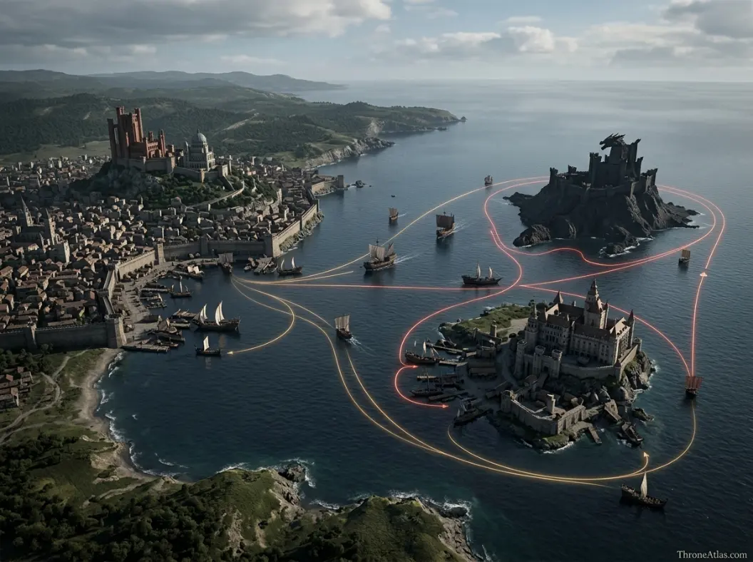
During the Dance of the Dragons, the bay and nearby Gullet become even more important because House Velaryon’s fleet, Dragonstone and competing royal capitals sit within the same maritime system. A blockade can pressure King’s Landing without taking its walls. A fleet moving through the Gullet can affect whether ships reach the capital.
This is why ThroneAtlas separates the Blackwater Bay map from the Crownlands page while linking them tightly. The regional page explains the political system; the bay page can zoom into naval routes and battle geometry.
Dragonstone: Royal Island, Targaryen Base and Eastern Shield
Dragonstone lies in Blackwater Bay’s outer maritime system and predates King’s Landing as the Targaryen seat in Westeros. Its volcanic island fortress gives the Crownlands a powerful offshore stronghold close to the capital yet distinct enough to become an alternative court during succession crises.
Dragonstone’s importance comes from this paradox of proximity and separation. It is close enough to threaten or reinforce King’s Landing quickly, but water creates a natural boundary. A claimant can hold Dragonstone while an enemy holds the Red Keep, producing two rival centers only a short sea journey apart.
The island is also tied to Targaryen identity in a way King’s Landing is not. Dragonstone existed before the Conquest and preserves Valyrian architectural and dynastic associations. Traditionally, the heir to the Iron Throne is connected to the title Prince or Princess of Dragonstone, giving the castle succession symbolism in addition to military value.
In House of the Dragon, these qualities make it the natural Black base for Rhaenyra. Dragons, Velaryon fleets and access to the Narrow Sea turn a small island into a strategic competitor to the much larger capital.
Driftmark and the Velaryon Maritime Network
Driftmark, seat of House Velaryon, lies near Dragonstone and forms part of the maritime power network east of King’s Landing. Velaryon ships, wealth and ports make the island strategically important whenever control of Blackwater Bay, the Gullet or Narrow Sea trade becomes contested.
House Velaryon demonstrates how a small land area can support enormous political influence when it sits on the right sea lanes and develops maritime expertise. Corlys Velaryon’s voyages expand the family’s wealth beyond what local agriculture alone could provide. Ships multiply the value of location.
During the Dance, Driftmark and Dragonstone work as complementary bases. The Targaryen claimant provides dragons and royal legitimacy; the Velaryons provide fleet power and seaborne logistics. That alliance can threaten King’s Landing by controlling what approaches from the east.
The Gullet battle also shows the network’s vulnerability. A fleet must defend routes, ports and ships spread over water. Sea power creates reach but also exposes multiple assets. The Crownlands map becomes much clearer when these islands are treated as active nodes rather than scenery offshore.
Duskendale, Rosby and Stokeworth: The Capital’s Near Neighbors
Duskendale, Rosby and Stokeworth are among the mainland locations that give the Crownlands depth beyond King’s Landing. Duskendale is a notable town and port, while Rosby and Stokeworth sit close enough to the capital that their roads, food and political loyalties can matter during sieges and succession crises.
Capitals survive through hinterlands. A ruler needs nearby estates capable of supplying grain, horses, manpower and safe routes. When those local houses change allegiance or when armies occupy the roads, the capital’s strategic situation changes even if its walls are untouched.
Rosby and Stokeworth are particularly useful map markers because they sit within the immediate political orbit of King’s Landing. Characters can reach them without crossing half the continent, making them natural sites for royal commands, marriages, levies and supply discussions.
Duskendale has a different profile because of its urban and coastal character. The Defiance of Duskendale in later Targaryen history demonstrates how a Crownlands town can become the center of a royal crisis. The event is powerful precisely because it occurs so close to the crown’s own geographic heartland.
Crackclaw Point and the Rough Eastern Mainland
Crackclaw Point projects into the waters east of the central Crownlands and is known for rugged terrain and locally independent houses. Its geography complicates the assumption that land near King’s Landing is uniformly easy for the crown to control.
Royal proximity does not erase difficult ground. Broken terrain, forests, coastal inlets and strong local identities can make a comparatively small area resistant to outside movement. The houses of Crackclaw Point historically value autonomy and can respond differently to wider factional pressures than more court-connected nobles near the capital.
The peninsula also sits within the maritime world linking Blackwater Bay to the Narrow Sea. That means local roads and coves can matter during conflict even when no giant city sits there. Small geographic features can provide hiding, landing or movement opportunities larger maps ignore.
For topical authority, this is why a dedicated Crackclaw Point map strengthens the Crownlands cluster. The regional page establishes the peninsula’s role; the local page can explain its houses and terrain in detail.
Rook’s Rest and the Crownlands as a Dragon Battlefield
Rook’s Rest shows how Crownlands castles become frontline targets during the Dance of the Dragons. Its proximity to the rival power centers around King’s Landing and Dragonstone means a local siege can quickly draw dragons and senior claimants into direct combat.
The Battle at Rook’s Rest is geographically revealing because it occurs within the capital’s broader strategic neighborhood rather than at the edge of the continent. Forces operating from King’s Landing can move against nearby Black-aligned positions, while Dragonstone-based riders can respond by air.
That compressed distance makes escalation fast. In an ordinary war, a relief army might need days to arrive. With dragons, a local operation can become a royal dragon battle almost immediately. Yet the ground army still matters because castles are occupied by men after dragons leave.
The Crownlands are therefore the region where aerial and conventional geography overlap most intensely during the early Dance. Roads, forts, bays and flight paths all have to be mapped together.
Why the Crownlands Were Created After Aegon’s Conquest
The Crownlands were assembled as a royal domain after Aegon’s victory rather than inherited as one of the seven old kingdoms. Creating a territory around the new capital gave the Iron Throne direct access to nearby lords, roads, ports and defensive positions without depending entirely on another lord paramount’s region.
This administrative design is easy to overlook because later maps make the Crownlands look as natural as the North or Dorne. Historically, however, they are part of the political technology of unification. The new monarchy needs land it can treat as its immediate base.
King’s Landing becomes the center, while houses in the surrounding zone answer more directly to the crown. Dragonstone retains a special Targaryen role. Driftmark and other islands add naval capability. Together, these pieces give the monarchy a geographic foundation separate from the older kingdoms it conquered.
The absence of an ancient “Crownlands king” also helps explain the region’s identity. Loyalty is more court-oriented and fragmented among local houses rather than organized around one pre-Targaryen regional dynasty. When the throne itself divides during the Dance, those local loyalties become especially unstable.
How to Read Crownlands Control During Civil War
A Crownlands civil-war map should separate the capital, nearby mainland castles, islands and sea lanes instead of coloring the entire region for whoever holds the Iron Throne. King’s Landing can be Green while Dragonstone and Driftmark are Black; later the capital can change hands while rival armies and dragons remain active nearby.
This is the best example in Westeros of why possession and control are different metrics. The Red Keep is enormously symbolic, but a rival with dragons on Dragonstone, ships around the Gullet and loyal castles on the mainland can still threaten the city. Conversely, an occupier of King’s Landing may inherit food shortages, hostile streets and vulnerable roads.
Time layers solve the mapping problem. Mark which side holds each node at the beginning of a season or campaign, then update after major battles and occupations. Sea control should be shown separately because a city can be land-secure and maritime-isolated.
This approach makes both House of the Dragon and Game of Thrones clearer. Stannis’s attack, the Dance, Daenerys’s arrival on Dragonstone and later attacks on King’s Landing all use the same underlying geography in different political contexts.
Capital, Islands and Maritime Control
Continue Exploring ThroneAtlas
Crownlands Map: King’s Landing, Dragonstone, Driftmark, Houses & Roads: FAQs
Where are the Crownlands?
The Crownlands surround King’s Landing and Blackwater Bay on the eastern side of Westeros, including nearby mainland territories and important islands such as Dragonstone and Driftmark.
Who rules the Crownlands?
They are the royal heartland rather than a traditional lord-paramount kingdom. Local houses owe allegiance within a region centered on the Iron Throne, while control can become fragmented during civil war.
Were the Crownlands one of the Seven Kingdoms before Aegon?
No. The territory was not a separate ancient crowned kingdom. The Crownlands emerged as the new monarchy’s immediate domain around Aegon’s capital and nearby loyal houses after the Conquest.
Is Dragonstone part of the Crownlands?
It is generally treated within the Crownlands’ royal-island geography and is deeply tied to Targaryen rule. Its offshore position also gives it a distinct strategic identity from mainland Crownlands castles.
Where is Driftmark?
Driftmark is an island near Dragonstone in the Narrow Sea/Blackwater Bay maritime network and is the seat of House Velaryon, whose fleet becomes especially important during the Dance of the Dragons.
Why is Blackwater Bay important?
It gives King’s Landing maritime trade access but also provides a direct naval avenue of attack. The Battle of Blackwater and the Dance of the Dragons both demonstrate how control of nearby waters can determine the capital’s security.
What towns are near King’s Landing?
Rosby and Stokeworth are important nearby lordly seats, while Duskendale is a larger Crownlands town and port. Their roads and resources matter to the capital’s supply and defense.
Is Crackclaw Point in the Crownlands?
Yes. Crackclaw Point lies on the eastern mainland and is known for rugged terrain and locally independent houses, showing that territory close to the capital is not necessarily easy to control.
Where is Rook’s Rest?
Rook’s Rest is a Crownlands castle that becomes the site of a major dragon battle during the Dance. Its position within the King’s Landing–Dragonstone strategic zone makes it an important local target.
Why can King’s Landing fall without ending a war?
The capital is symbolically crucial, but rival claimants can retain dragons, armies, islands, fleets and regional allies elsewhere. Civil-war control depends on the wider network, not only possession of the Red Keep.
The Geography Behind the Story
The Crownlands are the royal region around King’s Landing and Blackwater Bay. Unlike the old kingdoms, they were formed around Targaryen rule after Aegon’s Conquest. Their major strategic nodes include King’s Landing and the Red Keep, Dragonstone, Driftmark, Duskendale, Rosby, Stokeworth, Crackclaw Point and Rook’s Rest. The region is best understood as a capital-support network of roads, ports, islands and nearby houses rather than as one ancient kingdom with a single regional dynasty. The deeper value of this page is not memorizing names. It is seeing how roads, rivers, coasts, castles, distance, food, dragons, armies, and old political borders determine what characters can realistically do next. That is the layer ThroneAtlas is built to make visible.