Free Cities Map: Braavos, Pentos, Volantis, Lys, Myr & More
A complete visual atlas of the Nine Free Cities of western Essos—where they sit, how sea and river routes connect them, why the southern cities fight over the Disputed Lands, and how Braavos, Pentos and Volantis pull the political map in very different directions.
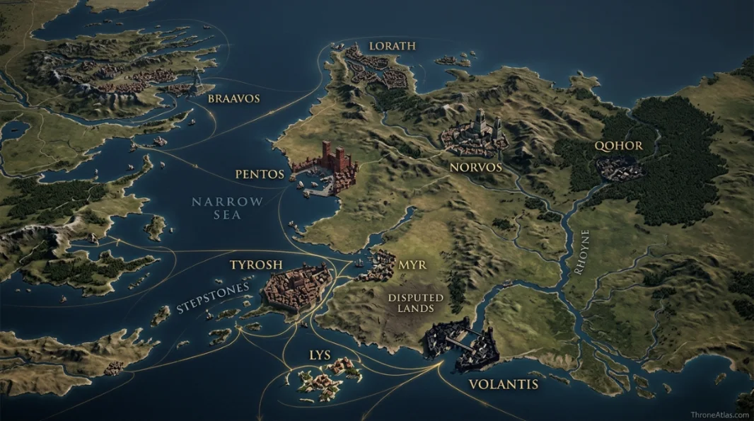
The Nine Free Cities are Braavos, Pentos, Lorath, Norvos, Qohor, Myr, Tyrosh, Lys and Volantis. They occupy western Essos east of Westeros: Braavos, Lorath, Lys and Tyrosh are island cities; Pentos, Myr and Volantis are coastal; Norvos and Qohor are inland. Their geography explains their economies and rivalries, especially the repeated conflicts among Myr, Lys and Tyrosh over the Disputed Lands and Stepstones.
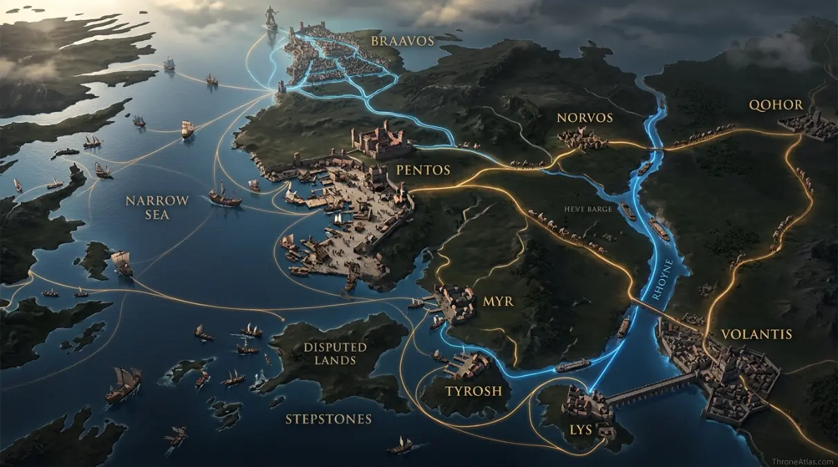
Free Cities Map — Western Essos at a Glance
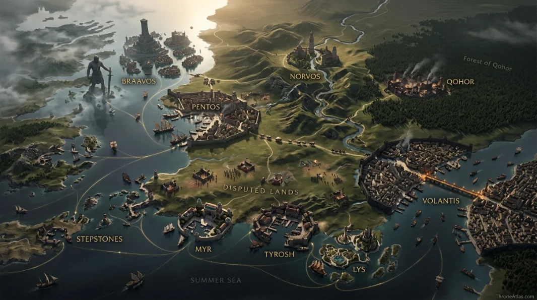
This is the hub map for the nine independent city-states. The goal is to show relative position, travel logic and political friction without pretending that every sea lane or territorial edge is fixed.
Nine Free Cities, Disputed Lands & Major Routes
Tap a marker to reveal why that place matters. Marker positions are interpretive unless the canon confidence note says otherwise.
Canon Confidence & What This Map Claims
The locations of the Nine Free Cities and major surrounding features are established by published maps. Political influence beyond the cities is fluid, however, and borders in the Disputed Lands should never be drawn like permanent modern frontiers.
In This Guide
- Visual Atlas & Map
- Canon Confidence
- Map Index
- Where Are the Free Cities on the World Map?
- Why Braavos and Pentos Dominate the Westeros-Facing Side
- Myr, Lys and Tyrosh: The Southern Rivalry Triangle
- Volantis and the Rhoyne: The Southeastern Anchor
- Norvos, Qohor and Lorath: Why the Quiet Cities Still Matter
- How to Read Trade, Sellswords and Political Power on the Free Cities Map
- Cartographer Field Notes
- Direct Answers
- Source & Canon Basis
- FAQs
Free Cities Map: The Nine-City System
There are nine Free Cities
Braavos, Pentos, Lorath, Norvos, Qohor, Myr, Tyrosh, Lys and Volantis form the classic group.
Geography varies sharply
Some are islands, some coastal ports and two are inland, so there is no single “Free City” geographic model.
Valyria shaped most of them
Most originated as Valyrian colonies or outposts; Braavos is the great exception, founded by escaped slaves.
The south is conflict-heavy
Myr, Lys and Tyrosh repeatedly contest the Disputed Lands and nearby Stepstones.
Braavos pulls north
Its lagoon and anti-slavery identity make it politically distinct from the southern Valyrian-descended cities.
Volantis anchors the southeast
At the mouth of the Rhoyne, the oldest Free City ties western Essos to the river system and routes toward Slaver’s Bay.
Pentos faces Westeros
Its position across the Narrow Sea makes it a recurring arrival point for exiles, merchants and political travelers.
Trade is the connective tissue
Ships, roads, rivers and sellsword networks make these city-states part of one system even when they are rivals.
Places, Zones & Connections to Plot
| Place | Zone | Why It Matters | How to Read It on the Map |
|---|---|---|---|
| Braavos | Northwestern islands / lagoon | Powerful maritime city with the Iron Bank and a strong anti-slavery tradition. | Read it as the northern naval pole facing Westeros and the Shivering Sea. |
| Pentos | Narrow Sea coast | Major port directly across from Westeros and a frequent gateway into Essos. | A western coastal hinge connecting sea travel with inland roads. |
| Lorath | Northern islands | Remote and comparatively weak city-state in the Shivering Sea sphere. | Isolation is part of its strategic identity; distance reduces its weight in southern wars. |
| Norvos | Inland hills / Noyne | Religious, walled inland city connected to river and caravan routes. | A land-route node rather than a maritime power. |
| Qohor | Forest of Qohor | Inland city near vast forest and eastern caravan approaches. | Shows how the Free Cities system extends beyond the coast. |
| Myr | Southern coast | Craft center and repeated rival in struggles over the Disputed Lands. | Read it as one corner of the Myr–Lys–Tyrosh strategic triangle. |
| Tyrosh | Island north of Stepstones | Fortified harbor controlling approaches near the Stepstones. | A maritime military-commercial node close to contested sea lanes. |
| Lys | Island off Disputed Lands | Prosperous island city deeply tied to Valyrian heritage and southern trade. | Another corner of the southern rivalry triangle, highly dependent on ships. |
| Volantis | Mouth of the Rhoyne | Oldest Free City, huge port and river crossing with the Black Walls and Long Bridge. | Southern anchor connecting Free Cities trade to the Rhoyne and Summer Sea. |
Where Are the Free Cities on the World Map?
The Free Cities occupy western Essos across the Narrow Sea from Westeros, stretching from Braavos and Lorath in the north to Volantis in the south and from coastal islands to inland Norvos and Qohor.
Looking at them as one colored block hides the point. The Free Cities are a network separated by water, forest, hills and rival spheres of influence. A traveler from King’s Landing reaches Pentos or Braavos very differently from someone trying to reach Qohor or Norvos, and a merchant moving from Lys to Volantis thinks in sea lanes rather than continental roads.
Their western position makes them the part of Essos most tightly woven into Westerosi politics. Exiles flee there, sellswords gather there, banks finance wars there and ships cross back and forth constantly. Yet the region does not behave like one country. Each city-state has its own government, customs, military interests and commercial priorities.
This map therefore treats the Free Cities as a system of nodes. The spaces between them—Narrow Sea, Rhoyne, forests, Disputed Lands and Stepstones—are as important as the city labels, because movement through those spaces determines which city can project power where.
Why Braavos and Pentos Dominate the Westeros-Facing Side
Braavos and Pentos are the Free Cities most immediately associated with crossings from Westeros because both sit on the western side of Essos, but their political identities and physical geography are very different.
Pentos faces the Narrow Sea directly and often functions as a first continental landing point. That makes it intuitive on a map: sail east from Westeros and the city can sit at the beginning of a longer journey into Essos. Its surrounding flatlands and roads then open connections inland.
Braavos is more geographically distinctive. The city is built among islands and lagoon waters in the northwest, protected by its maritime setting and famous entrance. Its founding outside the normal Valyrian colonial story also gives it a political culture sharply different from many slaveholding or slave-trading cities farther south.
For readers tracking Arya, Daenerys’s early exile history, merchants or the Iron Bank, the key is not to lump the two cities together as “across the sea.” Pentos is a coastal gateway; Braavos is a northern maritime power. Their map positions create different story functions.
Myr, Lys and Tyrosh: The Southern Rivalry Triangle
Myr, Lys and Tyrosh form the most conflict-prone cluster on the Free Cities map because all three compete for influence over the Disputed Lands and nearby Stepstones.
The triangle is easy to understand visually. Myr sits on the mainland, while Tyrosh and Lys are island powers close to the contested southern coast. None can ignore the others because territory, trade lanes and mercenary power overlap. That proximity produces recurring short wars, alliances and reversals rather than one permanent settlement.
The Disputed Lands should therefore be shown as a contested zone, not assigned permanently to one color. Armies there are often sellsword-heavy, which turns contract networks into part of geography. A city does not have to annex every field to shape the map; it can pay a company to hold a road, raid a rival or defend an approach.
The Stepstones add a maritime version of the same instability. Pirates, fleets and temporary occupations can change control quickly. On a map, the southern Free Cities cluster should look dynamic—three ports staring at both contested land and contested sea.
Volantis and the Rhoyne: The Southeastern Anchor
Volantis sits at the mouth of the Rhoyne and is the oldest of the Free Cities, giving it a strategic position where river traffic, Summer Sea shipping and routes toward Slaver’s Bay converge.
No other Free City is so defined by a single river mouth. The Rhoyne is not merely a blue line entering the sea; it is a continental transport system connecting settlements and older Rhoynish history to the southern coast. Volantis grew around that advantage, and its two halves on opposite banks are physically joined by the Long Bridge.
Its geography also points southeast toward the great trade routes beyond the classic Nine Free Cities. Ships can move toward Slaver’s Bay and the wider Summer Sea, while inland routes follow the river country north. That makes Volantis a natural edge city: part of the western Essos system but already looking toward the larger east.
Politically, the Black Walls and Old Blood create an internal map of privilege inside the city. This is a reminder that “city map” can mean more than streets. Social borders can be as real as rivers when they determine who may live inside a protected district and who remains outside it.
Norvos, Qohor and Lorath: Why the Quiet Cities Still Matter
Norvos, Qohor and Lorath receive less screen attention than Braavos or Volantis, but they complete the geography of the Free Cities by showing inland, forest and northern-island models of power.
Norvos sits inland among hills and along the Noyne system, so its movement logic is overland and riverine. Qohor lies farther east beside the great forest bearing its name, connected to caravan routes and eastern approaches. Neither can be understood with a harbor-first map.
Lorath goes the other way: it is maritime but isolated. Its comparative weakness is partly geographic. A remote island city with fewer immediate war corridors behaves differently from Tyrosh sitting beside the Stepstones or Pentos facing Westeros. Distance can be a shield and a limitation at the same time.
Including these cities prevents the hub from becoming a list of places that happened to receive television scenes. ThroneAtlas is mapping the world, not only the camera. Their presence explains the full western Essos system and creates clean internal-link opportunities as the atlas expands.
How to Read Trade, Sellswords and Political Power on the Free Cities Map
Power in the Free Cities moves through ports, contracts, banks, fleets, rivers and caravan routes as much as through territorial borders, so the map should be read as a network rather than a collection of miniature kingdoms.
A Westerosi map trains readers to look for a castle and the land ruled from it. The Free Cities require a different habit. A city-state can finance influence far beyond its walls, hire sellswords instead of maintaining one feudal levy, and use ships to reach a distant conflict faster than an army could march across country.
That is why names such as the Golden Company, Iron Bank or merchant houses matter geographically even though they are not territories. They create routes of money and manpower. A claimant in Westeros can be affected by decisions made in Braavos or Pentos without either city conquering a single Westerosi acre.
The best map therefore overlays three systems: fixed cities, semi-fixed transport geography, and fluid political influence. Keep those layers separate and the Free Cities become much easier to understand—and much harder to reduce to “the places east of Westeros.”
How Each Marker Changes the Map
These notes are deliberately practical. They explain what each point does to movement, power, trade, defense, religion or social life instead of repeating a list of place names.
Braavos
On the atlas, Braavos should not be treated as an isolated pin. Its position in Northwestern islands / lagoon matters because Powerful maritime city with the Iron Bank and a strong anti-slavery tradition.. The practical map-reading question is therefore Read it as the northern naval pole facing Westeros and the Shivering Sea.. That relationship is more useful than pretending the world has modern surveyed coordinates.
Pentos
Pentos earns a place on this map for a different reason from a famous capital or battlefield. In Narrow Sea coast, Major port directly across from Westeros and a frequent gateway into Essos.. When following characters, fleets, merchants or armies, read this point through the lens of A western coastal hinge connecting sea travel with inland roads.; it explains what can realistically happen around it.
Lorath
A good map gives Lorath context, not just a label. Here the relevant geographic frame is Northern islands. Remote and comparatively weak city-state in the Shivering Sea sphere.. For route and strategy purposes, the important takeaway is Isolation is part of its strategic identity; distance reduces its weight in southern wars., which is why this location connects naturally to the surrounding markers.
Norvos
The cartographic value of Norvos comes from its relationship with the wider Inland hills / Noyne network. Religious, walled inland city connected to river and caravan routes.. In practical terms, A land-route node rather than a maritime power.. That makes the point meaningful even when the source material never provides exact mileage or a street-by-street survey.
Qohor
On the atlas, Qohor should not be treated as an isolated pin. Its position in Forest of Qohor matters because Inland city near vast forest and eastern caravan approaches.. The practical map-reading question is therefore Shows how the Free Cities system extends beyond the coast.. That relationship is more useful than pretending the world has modern surveyed coordinates.
Myr
Myr earns a place on this map for a different reason from a famous capital or battlefield. In Southern coast, Craft center and repeated rival in struggles over the Disputed Lands.. When following characters, fleets, merchants or armies, read this point through the lens of Read it as one corner of the Myr–Lys–Tyrosh strategic triangle.; it explains what can realistically happen around it.
Tyrosh
A good map gives Tyrosh context, not just a label. Here the relevant geographic frame is Island north of Stepstones. Fortified harbor controlling approaches near the Stepstones.. For route and strategy purposes, the important takeaway is A maritime military-commercial node close to contested sea lanes., which is why this location connects naturally to the surrounding markers.
Lys
The cartographic value of Lys comes from its relationship with the wider Island off Disputed Lands network. Prosperous island city deeply tied to Valyrian heritage and southern trade.. In practical terms, Another corner of the southern rivalry triangle, highly dependent on ships.. That makes the point meaningful even when the source material never provides exact mileage or a street-by-street survey.
Volantis
On the atlas, Volantis should not be treated as an isolated pin. Its position in Mouth of the Rhoyne matters because Oldest Free City, huge port and river crossing with the Black Walls and Long Bridge.. The practical map-reading question is therefore Southern anchor connecting Free Cities trade to the Rhoyne and Summer Sea.. That relationship is more useful than pretending the world has modern surveyed coordinates.
Fast Answers About the Map
Nine: Braavos, Pentos, Lorath, Norvos, Qohor, Myr, Tyrosh, Lys and Volantis.
Several face the Narrow Sea, but Pentos and Braavos are among the most important Westeros-facing gateways.
Braavos, Lorath, Lys and Tyrosh are island-based; the others are coastal or inland.
Myr, Lys and Tyrosh are the classic rivals for the Disputed Lands.
Volantis is traditionally described as the oldest and proudest of the Free Cities.
No. Slaver’s Bay lies farther east and south; it is a separate regional system that connects commercially and politically with Free City routes.
What This Atlas Is Based On
The Free Cities are best mapped by combining fixed geography with deliberately fluid political influence. The atlas avoids drawing modern-style borders where the lore describes changing control.
- A Song of Ice and Fire: Travel, politics, trade, character origins and city descriptions across the novels.
- A Dance with Dragons map material: Published map geography for the Free Cities, Rhoyne basin and surrounding regions.
- The World of Ice & Fire: Founding history, Valyrian connections, economies and major regional relationships.
- Fire & Blood: Triarchy, Stepstones and earlier political history of the southern Free Cities.
Continue Exploring ThroneAtlas Maps
Free Cities Map FAQs
What are the Nine Free Cities?
Braavos, Pentos, Lorath, Norvos, Qohor, Myr, Tyrosh, Lys and Volantis are the nine independent city-states traditionally grouped as the Free Cities of western Essos.
Are all the Free Cities on the coast?
No. Norvos and Qohor are inland. Pentos, Myr and Volantis are coastal, while Braavos, Lorath, Lys and Tyrosh are island cities.
Why are they called Free Cities?
The name reflects their status as self-governing city-states after the fall of Valyria, although their origins and degrees of autonomy under the Valyrian Freehold differed.
Was Braavos founded by Valyria?
No in the normal colonial sense. Braavos was secretly founded by escaped slaves fleeing the Valyrian Freehold, which helps explain its distinct anti-slavery identity.
Where are the Disputed Lands?
They lie in southwestern Essos between the spheres of Myr, Lys and Tyrosh and have repeatedly been contested by those cities.
What is the Triarchy?
Myr, Lys and Tyrosh formed an alliance known as the Triarchy during the historical period explored in Fire & Blood and House of the Dragon. Their combined power focused heavily on the Stepstones and southern trade.
Which Free City is largest?
Sources emphasize different measures, but Volantis is among the great cities of the known world and is physically enormous; population and urban area should not be reduced to one unsupported ranking.
Which Free City has the Iron Bank?
Braavos. The Iron Bank makes the city influential far beyond its physical territory because lending can shape wars and dynastic politics in Westeros.
How do the Free Cities connect to Daenerys?
Daenerys spends her early exile in the western Essos world and later disrupts trade and slavery farther east, affecting powerful interests including Volantis and other cities tied to those economic systems.
Is this map book canon or show canon?
The broad city locations come from published world maps and lore. Screen adaptations may simplify travel or emphasize different places, so ThroneAtlas labels adaptation-specific geography rather than blending it silently with book canon.
The Free Cities Are a Network, Not a Country
Western Essos becomes much clearer once the Nine Free Cities are read as independent nodes connected by sea, rivers, roads, finance, trade and mercenary power. Braavos and Pentos face Westeros, Norvos and Qohor pull the map inland, Myr–Lys–Tyrosh form a contested southern triangle, and Volantis anchors the Rhoyne mouth. The spaces between them explain as much as the city walls themselves.