Lys Map: Lys the Lovely, Disputed Lands & Trade Routes
A map-first guide to Lys the Lovely, the southern island Free City positioned between the Disputed Lands and Volantis—its maritime routes, Valyrian identity, rivalry with Myr and Tyrosh, and role in the Triarchy.
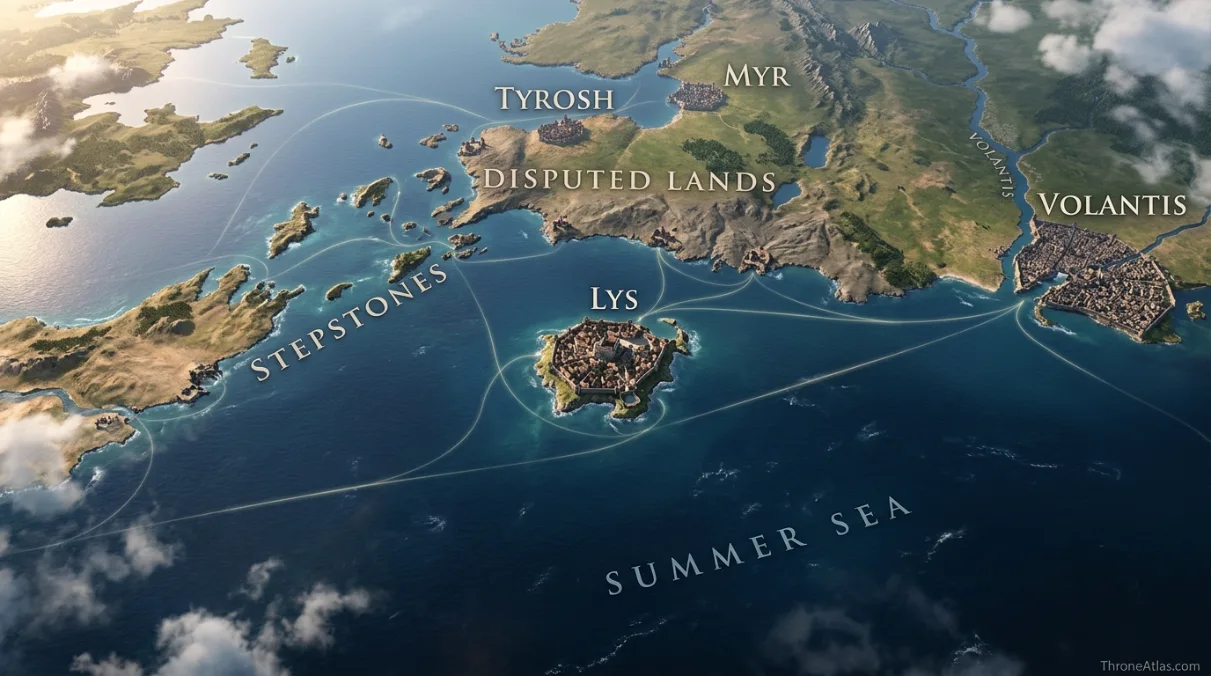
Lys is an island Free City off the southwestern coast of Essos, southeast of Tyrosh, west of Volantis and close to the Disputed Lands. Its position makes it a maritime trading city and one corner of the long rivalry among Lys, Myr and Tyrosh. The city’s Valyrian heritage, fleet connections and dependence on sea routes are more important to reading the map than any invented street plan.
Lys Map — Island Position & Southern Rivalries
Lys is best understood from outside the city walls first: island, sea routes, nearby rivals and the Disputed Lands. Its political history is inseparable from where it sits.
Lys, Tyrosh, Myr, Volantis & Disputed Lands
Tap a marker to reveal why that place matters. Marker positions are interpretive unless the canon confidence note says otherwise.
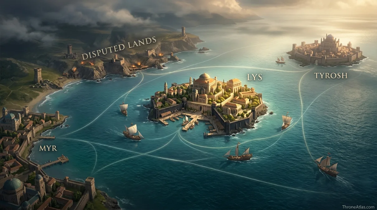
Canon Confidence & What This Map Claims
Lys’s island position and relationship to Tyrosh, Myr, Volantis and the Disputed Lands are established. A complete internal street map is not, so this atlas keeps urban details contextual and focuses on the stronger regional geography.
In This Guide
- Visual Atlas & Map
- Canon Confidence
- Map Index
- Where Is Lys on the Essos Map?
- Lys, Myr and Tyrosh: A Rivalry Created by Proximity
- Why Lys Is So Closely Associated With Valyria
- The Triarchy and the Stepstones
- Trade, Harbors and the Real Scale of Lys
- How Lys Connects to Westerosi Characters and History
- Cartographer Field Notes
- Direct Answers
- Source & Canon Basis
- FAQs
Lys Map: What Matters Most
Lys is an island city
Its politics and economy depend heavily on ships, harbors and access to southern sea routes.
It sits beside contested geography
The Disputed Lands lie close enough to pull Lys repeatedly into conflict with Myr and Tyrosh.
Valyrian heritage is unusually visible
Lys is famous for people and lineages preserving Valyrian-associated physical traits.
Trade is central
Luxury goods, pleasure industries and maritime commerce are part of the city’s reputation.
The Triarchy changed the region
Lys once allied with Myr and Tyrosh in a powerful coalition that fought over the Stepstones.
Volantis is the eastern giant
Lys lies west of Volantis, making the older city both neighbor and historical rival.
The Stepstones matter indirectly
Control of the islands affects trade passing between the Narrow Sea and southern routes.
Island geography limits land power
Lys projects influence by ships, allies and hired forces rather than by simply marching outward from city gates.
Places, Zones & Connections to Plot
| Place | Zone | Why It Matters | How to Read It on the Map |
|---|---|---|---|
| Lys | Southern island Free City | Prosperous island city with strong Valyrian cultural identity. | Center the map on sea access rather than a land-road network. |
| Disputed Lands | Mainland northeast / east | Long-contested territory among Lys, Myr and Tyrosh. | Show as a fluid conflict zone, not a fixed Lysene province. |
| Tyrosh | Northwest island | Frequent rival and sometime ally in the Triarchy. | Forms one side of the southern three-city triangle. |
| Myr | Mainland north / northeast | Craft-rich rival competing over the same continental zone. | The mainland counterpart in the rivalry system. |
| Volantis | East | Older and larger Free City with a history of regional expansion. | Eastern power that once dominated Lys and remains part of the wider balance. |
| Stepstones | West / southwest sea lanes | Island chain controlling routes toward the Narrow Sea. | Maritime instability here can directly affect Lysene trade and fleets. |
| Summer Sea routes | South | Long-distance shipping toward Volantis and farther east. | Lys is plugged into a much larger sea network than its small island suggests. |
| Lysene harbor | City edge | Practical gateway for ships, merchants and military movement. | The harbor is more strategically meaningful than speculative street detail. |
Where Is Lys on the Essos Map?
Lys is an island off the southwestern coast of Essos, close to the Disputed Lands, southeast of Tyrosh and west of Volantis.
That position explains nearly everything about its strategic history. Lys is protected by water but cannot ignore the mainland, because the Disputed Lands offer resources, influence and routes contested by neighboring city-states. It is therefore both insular and deeply entangled in continental politics.
The island also faces sea corridors leading west toward the Stepstones and east toward Volantis and the Summer Sea. A ship can connect Lys to distant markets without touching the mainland, which is why maritime power and commercial networks matter more than a large contiguous territory.
On a world map, Lys can look small. On a trade map, it sits at a busy junction. That difference is exactly why the city deserves its own atlas page rather than being treated as a footnote beneath the larger Free Cities hub.
Lys, Myr and Tyrosh: A Rivalry Created by Proximity
Lys repeatedly clashes with Myr and Tyrosh because the three cities sit around the same disputed mainland and nearby sea routes, making overlapping ambitions almost unavoidable.
The geometry is simple and powerful: one mainland city, two island cities, one contested zone. None needs to conquer the others directly to create constant conflict. It is enough to compete for roads, estates, ports, taxes, client rulers and mercenary contracts.
When the three cooperate, as in the Triarchy, the same proximity becomes an advantage. Fleets and resources can be combined quickly to intervene in the Stepstones. When the alliance fractures, the shared neighborhood turns former partners back into rivals just as quickly.
That is why the Disputed Lands should remain visually neutral on the map. Giving the whole region one permanent color teaches the wrong lesson. Its identity is uncertainty; its control is part of the story.
Why Lys Is So Closely Associated With Valyria
Lys preserves strong cultural and genealogical associations with the Valyrian Freehold, and the city’s people are often described with classic Valyrian features.
Geography matters here because the southern Free Cities were deeply connected to Valyrian expansion and trade. Lys was not an isolated island civilization that later borrowed Valyrian style; it grew inside a Valyrian-dominated regional system.
That legacy gives the city significance in dynastic stories. Lysene ancestry appears in noble genealogies, rumors and marriage networks, while the city’s reputation for beauty becomes entangled with ideas about Valyrian blood. A map cannot prove ancestry, but it can show why travel between Valyrian-descended communities was historically plausible.
Understanding Lys requires more than coordinates. It is a southern Free City whose island position, history and cultural reputation connect western Essos trade with the broader legacy of Valyria.
The Triarchy and the Stepstones
Lys joined Myr and Tyrosh in the Triarchy, and the alliance’s involvement in the Stepstones shows why the island city’s strategic horizon extends west toward the Narrow Sea.
The Stepstones are the broken island chain between southern Essos and Dorne. They sit on routes that matter to ships moving between the Narrow Sea and the Summer Sea. Piracy or toll-taking there can therefore affect merchants far beyond the islands themselves.
For Lys, participation in the Triarchy turns regional rivalry into coordinated projection. The city does not need to be physically adjacent to every Stepstone to care about who controls the passage. Fleets make distance behave differently from land warfare.
House of the Dragon gives this history extra visibility through the war involving Daemon Targaryen and Corlys Velaryon. The dedicated Battle of the Stepstones map handles that campaign; this atlas explains why Lys had a geographic reason to be involved at all.
Trade, Harbors and the Real Scale of Lys
Lys’s power is better measured by maritime reach, wealth and commercial connections than by the physical size of the island visible on a continental map.
A small island can sit at the center of a large network. Ships compress sea distance, while high-value goods make prosperity less dependent on controlling huge agricultural interiors. This is a familiar pattern in real maritime history and it is equally useful for reading the Free Cities.
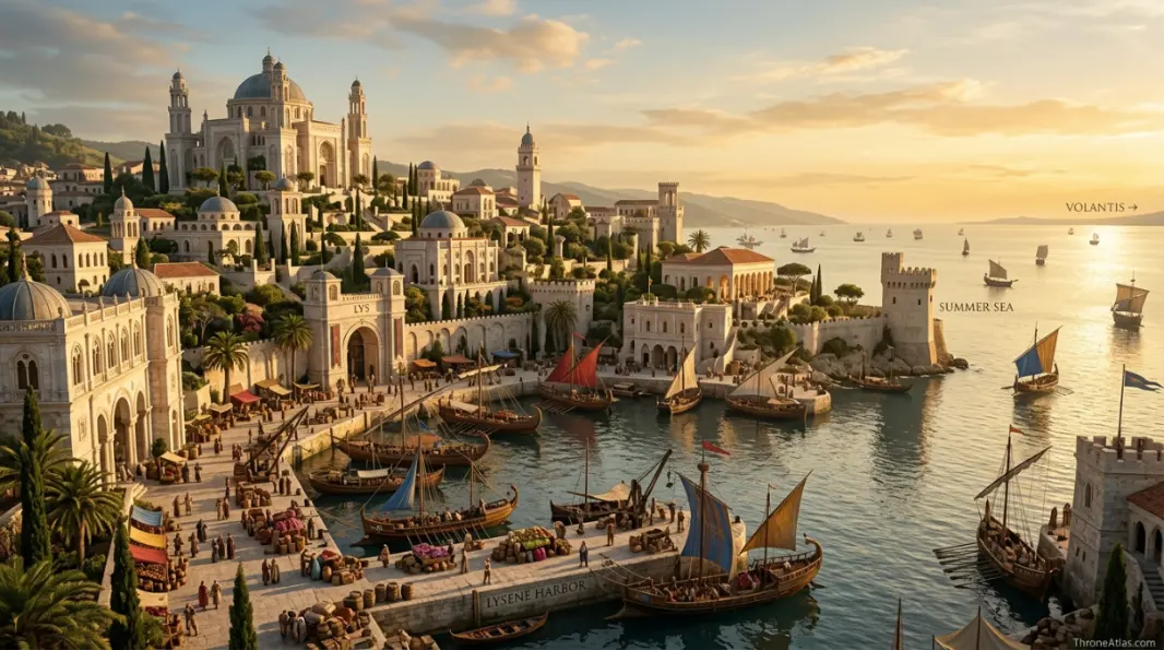
The harbor should therefore be treated as the functional front door of Lys. Merchants, envoys, sellsails and travelers enter the political system through maritime infrastructure. When war threatens shipping, the consequences spread quickly through the economy.
This is also why an internal street map would add less value than a regional route map unless the source gives reliable detail. The important user question is usually not “which alley is where?” but “where is Lys relative to Tyrosh, Myr, Volantis and Westeros?”
How Lys Connects to Westerosi Characters and History
Lys appears throughout Westerosi history through trade, exile, sellsails, dynastic ancestry and the movement of people between the Seven Kingdoms and the Free Cities.
The city’s influence often arrives indirectly. A Lysene individual can enter a Westerosi court; a sellsail can serve a claimant; a noble lineage can acquire Lysene ancestry; a war in the Stepstones can pull Westerosi fleets into the region. None of those stories requires Lys to conquer Westerosi land.
That pattern makes the city especially useful for a semantic content cluster. Links from Lys naturally connect to the Stepstones, Valyria, House Targaryen, Essos and future Free City pages without duplicating their intent. The Lys page owns the island-city query while supporting the wider map architecture.
For human readers, the map provides a simple mental model: Lys is the beautiful southern island city inside a rough neighborhood. Its walls and wealth face outward onto seas and contested politics, and that contrast is what makes the place memorable.
How Each Marker Changes the Map
These notes are deliberately practical. They explain what each point does to movement, power, trade, defense, religion or social life instead of repeating a list of place names.
Lys
On the atlas, Lys should not be treated as an isolated pin. Its position in Southern island Free City matters because Prosperous island city with strong Valyrian cultural identity.. The practical map-reading question is therefore Center the map on sea access rather than a land-road network.. That relationship is more useful than pretending the world has modern surveyed coordinates.
Disputed Lands
Disputed Lands earns a place on this map for a different reason from a famous capital or battlefield. In Mainland northeast / east, Long-contested territory among Lys, Myr and Tyrosh.. When following characters, fleets, merchants or armies, read this point through the lens of Show as a fluid conflict zone, not a fixed Lysene province.; it explains what can realistically happen around it.
Tyrosh
A good map gives Tyrosh context, not just a label. Here the relevant geographic frame is Northwest island. Frequent rival and sometime ally in the Triarchy.. For route and strategy purposes, the important takeaway is Forms one side of the southern three-city triangle., which is why this location connects naturally to the surrounding markers.
Myr
The cartographic value of Myr comes from its relationship with the wider Mainland north / northeast network. Craft-rich rival competing over the same continental zone.. In practical terms, The mainland counterpart in the rivalry system.. That makes the point meaningful even when the source material never provides exact mileage or a street-by-street survey.
Volantis
On the atlas, Volantis should not be treated as an isolated pin. Its position in East matters because Older and larger Free City with a history of regional expansion.. The practical map-reading question is therefore Eastern power that once dominated Lys and remains part of the wider balance.. That relationship is more useful than pretending the world has modern surveyed coordinates.
Stepstones
Stepstones earns a place on this map for a different reason from a famous capital or battlefield. In West / southwest sea lanes, Island chain controlling routes toward the Narrow Sea.. When following characters, fleets, merchants or armies, read this point through the lens of Maritime instability here can directly affect Lysene trade and fleets.; it explains what can realistically happen around it.
Summer Sea routes
A good map gives Summer Sea routes context, not just a label. Here the relevant geographic frame is South. Long-distance shipping toward Volantis and farther east.. For route and strategy purposes, the important takeaway is Lys is plugged into a much larger sea network than its small island suggests., which is why this location connects naturally to the surrounding markers.
Lysene harbor
The cartographic value of Lysene harbor comes from its relationship with the wider City edge network. Practical gateway for ships, merchants and military movement.. In practical terms, The harbor is more strategically meaningful than speculative street detail.. That makes the point meaningful even when the source material never provides exact mileage or a street-by-street survey.
Fast Answers About the Map
On an island off the southwestern coast of Essos, close to the Disputed Lands, southeast of Tyrosh and west of Volantis.
Yes. Lys is one of the Nine Free Cities.
No. Lys is an island city.
Myr and Tyrosh are the classic rivals over the Disputed Lands and nearby strategic interests.
Yes. Lys, Myr and Tyrosh formed the Triarchy during the historical era tied to the Stepstones conflict.
Its population and elite culture preserve strong Valyrian heritage, and Lysene characters are often described with Valyrian-associated features.
What This Atlas Is Based On
The strongest evidence for Lys is regional rather than street-level, so this atlas prioritizes the island’s position, rival cities and trade corridors.
- A Song of Ice and Fire: Lysene characters, trade references and political context.
- Fire & Blood: Triarchy and Stepstones-era history relevant to Lys, Myr and Tyrosh.
- The World of Ice & Fire: Free City origins, Valyrian heritage, economy and regional geography.
- Published Free Cities maps: Used for Lys’s relative position among the Disputed Lands, Tyrosh, Myr and Volantis.
Continue Exploring ThroneAtlas Maps
Lys Map FAQs
Where is Lys in Game of Thrones?
Lys lies on an island off southwestern Essos, close to the Disputed Lands and between the spheres of Tyrosh, Myr and Volantis.
Is Lys close to Westeros?
It is farther south and east than Pentos or Braavos but still part of the western Essos world connected to Westeros by major sea routes.
What is Lys known for?
Lys is known for beauty, luxury trade, pleasure houses, maritime commerce and strong cultural associations with Valyrian heritage.
Does Lys control the Disputed Lands?
Not permanently. The Disputed Lands are repeatedly contested among Lys, Myr and Tyrosh, so fixed modern-style borders would be misleading.
What was the Triarchy?
An alliance of Lys, Myr and Tyrosh that became a major regional power and intervened in the Stepstones.
Why did the Stepstones matter to Lys?
They affect shipping between the Narrow Sea and southern routes. Control, piracy or tolls there can directly influence Lysene trade.
Is Lys east or west of Volantis?
Lys lies west of Volantis.
Is Lys an island or a city-state?
Both: it is an island-based city-state and one of the Nine Free Cities.
Does House Targaryen have connections to Lys?
Targaryen-era history intersects Lys through Free City politics, Valyrian-descended families, exiles and the Stepstones conflicts.
How exact is this Lys map?
Its regional position is canon-based. Internal city layout and specific shipping lines are kept schematic unless the source material establishes them clearly.
Lys Is Small on Land, Large in the Network
Lys works as a map topic because its island position explains its entire political personality. It is maritime, commercially connected, culturally tied to Valyria and permanently exposed to the rivalry triangle with Myr and Tyrosh. Add the nearby Disputed Lands and Stepstones, and a small island becomes a major southern Essos node.