Duskendale Map: Dun Fort, Blackwater Bay Port & Crownlands Geography
A geographic guide to the Crownlands port that challenged royal authority — from the Dun Fort above the town to the harbor, Blackwater Bay and the roads back toward King’s Landing.
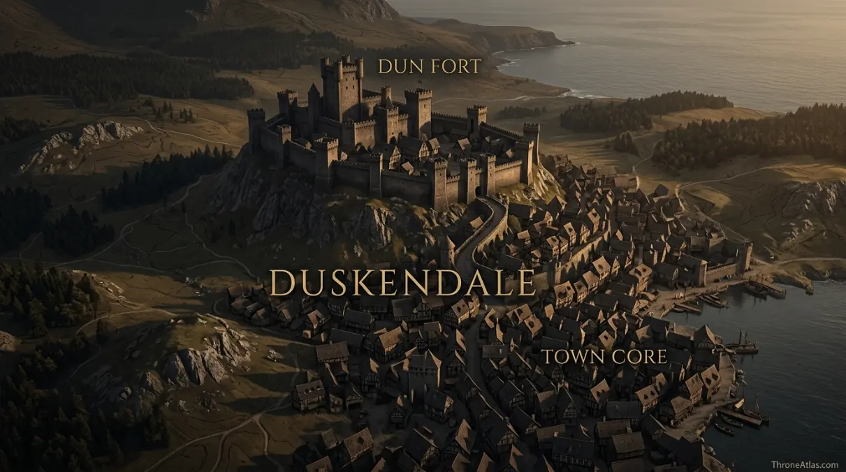
Duskendale is a walled port town in the Crownlands on Blackwater Bay, north of King’s Landing. The Dun Fort rises above the town, while the harbor ties Duskendale to maritime trade. Its most famous political episode is the Defiance of Duskendale in 277 AC, when Lord Denys Darklyn held King Aerys II captive until Ser Barristan Selmy rescued him.
Read Duskendale From Hill Fort to Harbor
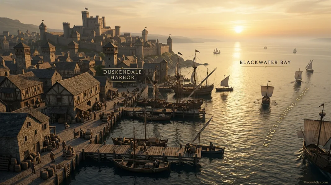
The map is organized vertically: the Dun Fort dominates the town from higher ground, the streets descend toward the harbor, and Blackwater Bay opens Duskendale to maritime movement. The King’s Landing road places the town inside the capital’s wider Crownlands network.
Canon Confidence & What This Map Claims
ThroneAtlas separates confirmed geography from useful reconstruction so a clean digital map never appears more certain than the underlying source.
Read the Map From Anchors to Story
- Visual Atlas
- Canon Confidence
- Key Takeaways
- Locations & Route Table
- Why Duskendale Is More Than a Minor Crownlands Port
- The Dun Fort: High Ground Above a Working Town
- Harbor, Blackwater Bay and the Commercial Shadow of King’s Landing
- The Defiance of Duskendale as a Map Event
- After the Darklyns: House Rykker and a Town That Outlives Its Lords
- How Precisely Can Duskendale Be Mapped?
- Fast Answers
- Sources & Method
- FAQs
Why Duskendale Is More Important Than Its Size Suggests
It is a port in the capital’s shadow
Duskendale’s harbor gives it economic value even though King’s Landing is the dominant city of Blackwater Bay.
The Dun Fort controls the visual hierarchy
The castle’s position above the town makes lordship and defense legible in the landscape.
House Darklyn defines its older identity
Duskendale was the Darklyn seat until the Defiance destroyed the house’s political future.
The Defiance is a geographic event
Aerys II was not simply “captured”; he was trapped inside a fortified town under royal pressure.
Barristan’s rescue bypassed a larger assault
The famous rescue matters partly because storming the town and fortress risked the king’s life.
House Rykker inherits the seat
After House Darklyn’s extinction, Duskendale passes to House Rykker.
Blackwater Bay connects town and capital
Sea geography makes Duskendale part of the same maritime system as King’s Landing.
Street-level detail remains uncertain
Canon supports the town-fort-harbor relationship more strongly than any exact block-by-block reconstruction.
Places, Routes & Strategic Connections
| Map Anchor | Type | Why It Matters |
|---|---|---|
| Dun Fort | Castle | The Darklyn stronghold on high ground overlooking Duskendale and its harbor. |
| Town Core | Town | The urban settlement beneath the Dun Fort, historically ruled by House Darklyn and later House Rykker. |
| Harbor | Port | Duskendale’s maritime edge and the source of much of the town’s commercial significance. |
| Blackwater Bay | Water | The bay linking Duskendale by sea to the waters around King’s Landing and the narrow sea approaches. |
| King’s Landing Road | Route | The overland connection toward the royal capital and the wider Crownlands. |
| Crownlands | Region | The royal region surrounding the capital in which Duskendale sits. |
| Darklyn Lands | Territory | The historical sphere of House Darklyn before the house was extinguished after the Defiance. |
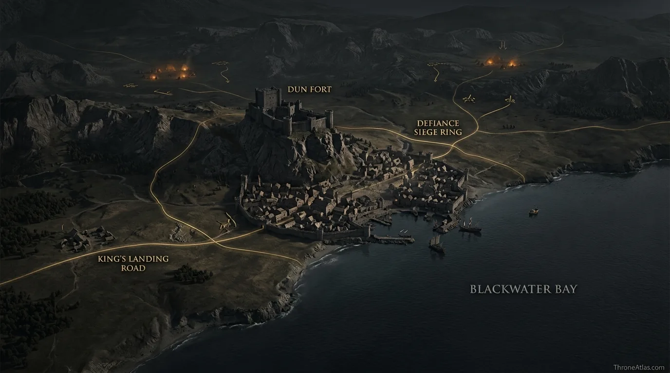
| Defiance Siege Ring | Event | A schematic marker for the royal pressure around Duskendale during the Defiance of 277 AC. |
Why Duskendale Is More Than a Minor Crownlands Port
Duskendale is easy to underestimate because it stands near King’s Landing, the largest and most politically important city in Westeros. Yet that proximity is exactly what makes Duskendale interesting. It is a substantial port in the Crownlands with its own history, ruling house and fortress, but it lives within the economic and political gravity of the royal capital.
Before Aegon’s Landing grew into King’s Landing, older settlements around Blackwater Bay already possessed local importance. Duskendale’s maritime position gave it access to trade, fishing and coastal movement. Once the new capital expanded, however, the balance changed. Merchants, royal administration and population increasingly concentrated around King’s Landing. Duskendale did not vanish, but its relative standing was altered.
The map makes that relationship easier to understand. Blackwater Bay is not empty blue space separating two unrelated locations. It is a shared maritime environment. Ships can move along the bay; roads link nearby Crownlands settlements; royal power radiates outward from the capital. A lord of Duskendale therefore rules a place with enough wealth and fortification to matter, while remaining close enough to the Iron Throne for defiance to become extraordinarily dangerous.
That tension underlies the town’s most famous event. Lord Denys Darklyn’s confrontation with Aerys II was not a rebellion launched from a distant mountain fastness. It happened practically on the monarchy’s doorstep, in a fortified commercial town that could be surrounded by royal forces. Duskendale’s geography turns the episode from an abstract court anecdote into a physical crisis.
For an atlas reader, the town is best understood as a three-part system: the Dun Fort above, the settlement below and the harbor opening onto Blackwater Bay. Those three layers explain both Duskendale’s local strength and the limits of that strength against the crown.
The Dun Fort: High Ground Above a Working Town
The Dun Fort is the dominant architectural anchor of Duskendale. Its value begins with elevation. A fortress raised on higher ground can observe approaches, command the town below and make direct assault more difficult than an attack across flat streets. The exact vertical profile is not measured in the narrative, but the relationship is clear enough to matter: castle above, town beneath, harbor beyond.
That arrangement reflects a common logic in Westerosi seats. A lord’s residence is not simply a large house inside a settlement. It is a defensible political center designed to survive unrest or invasion. In Duskendale, the fortress’s relationship with the town becomes particularly important during the Defiance because King Aerys II is held within the lord’s power while royal forces gather outside.
An attacking army faces a painful problem. Taking a town by storm is already costly; taking a fortified seat while the king is a hostage creates a second layer of risk. Siege pressure can isolate Duskendale, but an indiscriminate assault could provoke the king’s death. The Dun Fort therefore becomes more than masonry. It changes the options available to both sides.
For visual mapping, this is why the Dun Fort should not be represented as a random castle icon beside the word “Duskendale.” Its high-ground relationship to the settlement is the useful fact. Streets and harbor activity belong to the urban economy, while the fortress concentrates aristocratic power above it.
After House Darklyn is destroyed, the same physical seat survives under House Rykker. Political ownership changes more quickly than geography. The hill, town and harbor remain. That continuity is one reason maps are so helpful for history: they show the stable landscape across changing dynasties.
Harbor, Blackwater Bay and the Commercial Shadow of King’s Landing
Duskendale’s port gives the town a second identity beyond fortress politics. Blackwater Bay opens toward the narrow sea and also leads toward King’s Landing, making coastal movement a practical alternative to overland travel. That maritime position supports commerce, fishing and the circulation of people and information.
The phrase “in the shadow of King’s Landing” should not be read as meaning Duskendale has no economy of its own. Rather, the rise of the royal capital changes the scale at which the town competes. King’s Landing attracts court expenditure, royal taxation, artisans, merchants and a huge consumer population. A nearby port inevitably operates within that gravitational field.
This helps explain why the Darklyns could resent the changing economic order without being independent of it. Duskendale’s prosperity and identity predate the dominance of the new capital, yet the crown controls the political region and the larger commercial system. The tension between local privilege and central royal authority is therefore rooted in geography as well as pride.
The harbor also affects military possibilities. A town on a bay can potentially receive supplies or people by water, but naval access can also be watched or restricted. Coastal geography adds another dimension to any siege. The royal force outside the walls is not the only relevant pressure if sea movement can be controlled.
On this map, the harbor is intentionally given equal visual weight with the Dun Fort. One explains why Duskendale can defend itself; the other explains why the town matters economically. Without both, the Defiance can look like the irrational act of an obscure landed lord. With both visible, Duskendale appears as what it is: a proud, fortified port whose local importance collided disastrously with the expanding power of the Iron Throne.
The Defiance of Duskendale as a Map Event
In 277 AC, Lord Denys Darklyn sought concessions from King Aerys II. The king came to Duskendale with a relatively small escort and was seized. What followed is remembered as the Defiance of Duskendale, but the map reveals why the crisis lasted as it did.
Aerys was not merely a prisoner in an ordinary residence. He was inside a fortified town and castle controlled by the people holding him. Royal forces under Tywin Lannister could surround Duskendale and threaten destruction, yet the hostage at the center of the siege was the king himself. Every military option had to account for the possibility that an attack would lead to his death.
That transforms the Dun Fort into the central point of a hostage geometry. Outside are royal troops and roads back toward the capital. Inside are the Darklyns, their household and their captive. Beyond lies the harbor and bay. Each element affects the crisis even when the narrative does not provide a minute-by-minute tactical map.
Ser Barristan Selmy’s rescue becomes more impressive in that setting. Rather than resolving the standoff by a broad assault, Barristan infiltrated Duskendale, reached the king and brought him out. Once Aerys was safe, the balance changed completely. The royal host no longer had to protect a hostage inside enemy control.
The aftermath was catastrophic for House Darklyn. The house was extinguished, and House Rykker eventually held Duskendale. Politically, the Defiance also deepened Aerys II’s paranoia, influencing events that would later help poison the final years of Targaryen rule.
A responsible map does not draw a fictional exact siege trench or Barristan’s precise footpath. It shows the relationships that made the episode possible: royal road access, encirclement pressure, high fortress, town and bay.
After the Darklyns: House Rykker and a Town That Outlives Its Lords
One of the most useful lessons in historical mapping is that settlements often survive the dynasties that rule them. House Darklyn’s fall is dramatic, but Duskendale does not disappear when the family is destroyed. The town, fortifications, harbor and roads remain valuable. House Rykker becomes associated with the seat, demonstrating how political control can change while the underlying geography continues to shape regional life.
This matters because it prevents the Defiance from becoming the only lens through which Duskendale is understood. The town has a longer history than one crisis. Its people still work, trade and travel after the Darklyns are gone. Ships still use Blackwater Bay. The road to King’s Landing still matters. The Dun Fort still dominates the settlement even though different banners fly above it.
Duskendale also remains strategically relevant because location does not care which house currently holds the keys. Any power concerned with the Crownlands must think about ports, roads and defensible settlements around the capital. A town this close to King’s Landing can serve as a staging point, supply center or local administrative seat depending on the political moment.
The transition to House Rykker therefore belongs on the same page as the Defiance. It shows consequence rather than ending the story with punishment. House Darklyn’s political geography contracts to nothing, but Duskendale’s urban geography remains.
For readers tracing family history, this distinction is especially useful. “Where was House Darklyn?” and “where is Duskendale?” are related questions but not identical ones. One concerns a lineage whose power ended; the other concerns a place that persisted. The atlas keeps the durable place at the center and uses house history to explain how control of that place changed over time.
How Precisely Can Duskendale Be Mapped?
Duskendale is well anchored at the regional scale and less precisely documented at the street scale. Its location in the Crownlands on Blackwater Bay, its relationship with King’s Landing and the commanding presence of the Dun Fort are strong facts. Those are the foundations of this atlas.
Once a map tries to show the exact outline of town walls, individual dock lengths or the route Ser Barristan took during his rescue, confidence falls quickly. The novels are not architectural plans. Some visual adaptations and fan maps provide attractive layouts, but a useful reference page should not silently convert those designs into universal canon.
The same caution applies to the Defiance siege. It is reasonable to show a royal pressure ring around the town because Duskendale was invested by loyal forces. It is not reasonable to claim a specific camp sat exactly 420 meters from a particular gate unless a source says so. The event marker here is therefore conceptual.
At the regional scale, users can safely read Duskendale as a coastal town north of King’s Landing within the Crownlands network. At the settlement scale, they can read the Dun Fort as the elevated lordly seat and harbor as the town’s maritime outlet. At the tactical scale, details become more interpretive.
That layered approach answers the questions people actually bring to a map without pretending the fictional world contains data it never supplies. Where is Duskendale? Clear. Why did the Dun Fort matter? Clear. How did the port connect the town to Blackwater Bay? Clear. What exact alley did Barristan use? Unknown. Good cartography sometimes means drawing a line; just as often, it means knowing when not to draw one.
Fast Answers About the Map
Duskendale is a port town in the Crownlands on Blackwater Bay, north of King’s Landing.
The Dun Fort is the fortified seat overlooking the town.
House Darklyn ruled Duskendale until the aftermath of the Defiance of Duskendale.
House Rykker becomes associated with the town and Dun Fort after the Darklyns are extinguished.
Lord Denys Darklyn seized King Aerys II and held him until Ser Barristan Selmy rescued the king.
The king was a hostage inside a fortified town and castle, making a direct assault dangerous.
Yes. It lies within the Crownlands and is part of the capital’s broader Blackwater Bay region.
Only partly. Regional geography and major anchors are clear, but a complete surveyed street plan is not supplied by canon.
What This Atlas Is Based On
- George R. R. Martin’s A Song of Ice and Fire novels for references to Duskendale, House Darklyn and the political aftermath of the Defiance.
- The World of Ice & Fire for the Defiance of Duskendale, Aerys II, Barristan Selmy and the history of House Darklyn.
- Published Westeros maps and reference material for Duskendale’s Crownlands and Blackwater Bay position.
- Settlement-scale details are presented schematically where the books do not provide exact dimensions or street plans.
Continue Exploring ThroneAtlas Maps
Duskendale Map FAQs
Where is Duskendale on the map of Westeros?
Duskendale lies in the Crownlands on Blackwater Bay, north of King’s Landing.
Is Duskendale a city or a castle?
Duskendale is a port town. The Dun Fort is the castle that overlooks it.
Which house ruled Duskendale?
House Darklyn historically ruled Duskendale before being extinguished after the Defiance. House Rykker later held the seat.
What was the Defiance of Duskendale?
It was the 277 AC crisis in which Lord Denys Darklyn imprisoned King Aerys II inside Duskendale.
Who rescued Aerys II from Duskendale?
Ser Barristan Selmy infiltrated the town and rescued the king.
Why did Tywin Lannister not simply storm Duskendale?
Aerys II was being held hostage, so a direct assault risked the king’s death.
Is Duskendale on Blackwater Bay?
Yes. Its harbor opens onto Blackwater Bay, giving the town maritime and commercial importance.
How far is Duskendale from King’s Landing?
The sources establish Duskendale as relatively close within the Crownlands, but this atlas does not claim a modern exact mileage where canon does not provide one.
Does the Dun Fort still exist after House Darklyn falls?
Yes. The political house changes, but the fortified seat and town remain.
Is this Duskendale map exact at street level?
No. It is accurate at the level of major geographic relationships while treating fine street and siege details as schematic.
Why This Geography Matters
Duskendale matters because fortress, town and harbor occupy the same strategic space. Its location on Blackwater Bay gave House Darklyn enough local importance to challenge royal power, but its closeness to King’s Landing ensured that challenge could never remain local. The Defiance changed a dynasty; the geography endured.