Yi Ti Map
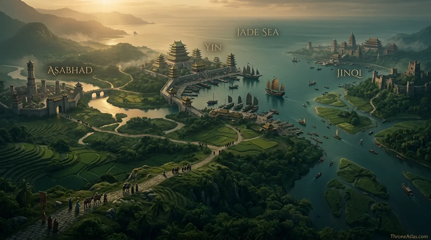
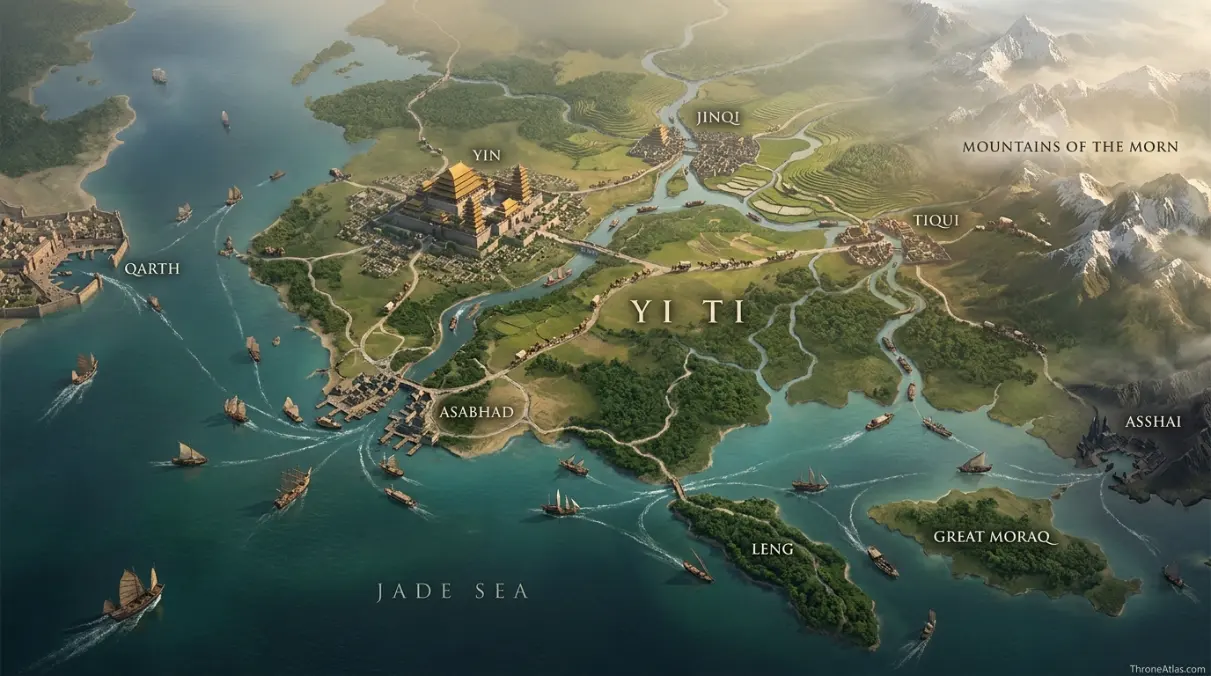
Yi Ti occupies the far eastern side of Essos beyond the Bone Mountains, with the Jade Sea along its southern edge. Known map anchors include the great port of Yin, western Asabhad, eastern Jinqi, inland Tiqui, the ruined city of Si Qo, and the Five Forts guarding the northeastern marches. Thick farmland, jungle, rivers and ancient stone roads connect those places. Because the far east is only partially described from a Westerosi perspective, this map emphasizes confirmed cities and regional relationships rather than sharp political borders.
Key Takeaways
Asabhad
Regional geography and connected routes
Confirmed places are separated from reconstructed corridors.
Yin, Jinqi and Tiqui
Bleeding Sea
Maintained for 2026 without a fixed day stamp.
Visual Atlas
Use the atlas markers to read the geography point by point.
Mapped Locations and Confidence
| Location / Zone | Confidence | Why it belongs on the map |
|---|---|---|
| 1. Asabhad | High | Asabhad stands at the western boundary of Yi Ti on the Jade Sea, east of the Bone Mountains. It is a trade gateway where caravans can begin journeys toward the Mountains of the Morn. |
| 2. Yin | High | Yin is the great port on the Jade Sea and the present seat of the Azure Emperor. Its coastal position makes it one of the clearest geographic and political anchors in the Golden Empire. |
| 3. Jinqi | High | Jinqi lies farther east near a delta along the Jade Sea and historically served as a martial imperial capital. Its position is especially relevant to threats coming from the eastern frontier. |
| 4. Tiqui | High | Tiqui lies inland toward the western hills and Great Sand Sea. It was once the seat of the Purple Emperors, showing how Yi Ti’s capitals shifted with dynasties. |
| 5. Si Qo | Medium | Si Qo was built in the jungle by the Scarlet Emperors and later fell into ruin. Its exact placement is less secure than Yin or Jinqi, so it is represented as an interior historical zone. |
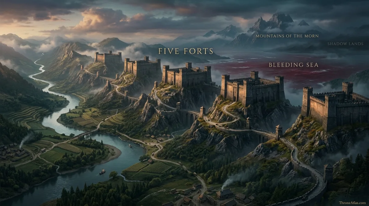
| 6. Five Forts | High | The Five Forts stand along the northeastern frontier between the Bleeding Sea and the Mountains of the Morn. Their scale and placement make them one of the most distinctive defensive features in the far east. |
| 7. Bleeding Sea | High | North of Yi Ti lies the Bleeding Sea, feeding a great river that runs south through the empire toward the Jade Sea. It helps define the northern side of the realm. |
| 8. Mountains of the Morn | High | These mountains rise east of Yi Ti toward the Shadow Lands. They form a major geographic barrier and orient the empire relative to Asshai and the eastern edge of mapped Essos. |
1. Asabhad
Asabhad stands at the western boundary of Yi Ti on the Jade Sea, east of the Bone Mountains. It is a trade gateway where caravans can begin journeys toward the Mountains of the Morn. This marker is included because Asabhad gives the region a firm orientation point. The far edges of the known world are described unevenly, so named cities, islands, rivers and mountains carry more weight than decorative border lines. Where the evidence thins, the atlas deliberately becomes less exact.
2. Yin
Yin is the great port on the Jade Sea and the present seat of the Azure Emperor. Its coastal position makes it one of the clearest geographic and political anchors in the Golden Empire. This marker is included because Yin gives the region a firm orientation point. The far edges of the known world are described unevenly, so named cities, islands, rivers and mountains carry more weight than decorative border lines. Where the evidence thins, the atlas deliberately becomes less exact.
3. Jinqi
Jinqi lies farther east near a delta along the Jade Sea and historically served as a martial imperial capital. Its position is especially relevant to threats coming from the eastern frontier. This marker is included because Jinqi gives the region a firm orientation point. The far edges of the known world are described unevenly, so named cities, islands, rivers and mountains carry more weight than decorative border lines. Where the evidence thins, the atlas deliberately becomes less exact.
4. Tiqui
Tiqui lies inland toward the western hills and Great Sand Sea. It was once the seat of the Purple Emperors, showing how Yi Ti’s capitals shifted with dynasties. This marker is included because Tiqui gives the region a firm orientation point. The far edges of the known world are described unevenly, so named cities, islands, rivers and mountains carry more weight than decorative border lines. Where the evidence thins, the atlas deliberately becomes less exact.
5. Si Qo
Si Qo was built in the jungle by the Scarlet Emperors and later fell into ruin. Its exact placement is less secure than Yin or Jinqi, so it is represented as an interior historical zone. This marker is included because Si Qo gives the region a firm orientation point. The far edges of the known world are described unevenly, so named cities, islands, rivers and mountains carry more weight than decorative border lines. Where the evidence thins, the atlas deliberately becomes less exact.
6. Five Forts
The Five Forts stand along the northeastern frontier between the Bleeding Sea and the Mountains of the Morn. Their scale and placement make them one of the most distinctive defensive features in the far east. This marker is included because Five Forts gives the region a firm orientation point. The far edges of the known world are described unevenly, so named cities, islands, rivers and mountains carry more weight than decorative border lines. Where the evidence thins, the atlas deliberately becomes less exact.
7. Bleeding Sea
North of Yi Ti lies the Bleeding Sea, feeding a great river that runs south through the empire toward the Jade Sea. It helps define the northern side of the realm. This marker is included because Bleeding Sea gives the region a firm orientation point. The far edges of the known world are described unevenly, so named cities, islands, rivers and mountains carry more weight than decorative border lines. Where the evidence thins, the atlas deliberately becomes less exact.
8. Mountains of the Morn
These mountains rise east of Yi Ti toward the Shadow Lands. They form a major geographic barrier and orient the empire relative to Asshai and the eastern edge of mapped Essos. This marker is included because Mountains of the Morn gives the region a firm orientation point. The far edges of the known world are described unevenly, so named cities, islands, rivers and mountains carry more weight than decorative border lines. Where the evidence thins, the atlas deliberately becomes less exact.
Yi Ti is larger than a single capital
Western references often reduce Yi Ti to Yin, but the map immediately shows a more complex realm. Multiple cities served as imperial capitals under different dynasties, while roads, rivers and frontier defenses spread across a broad region. Mapping those points prevents the Golden Empire from being treated as one exotic city on the edge of the world.
The Jade Sea is the southern spine
The Jade Sea connects Asabhad, Yin and Jinqi to the wider maritime trading world. It also explains why Yi Ti belongs on the same atlas network as Qarth, Leng, Great Moraq and Asshai. Coastal movement is one of the strongest confirmed structures in a region where many inland details are deliberately sparse.
Roads, farms and jungles
Yi Ti is described with dense agriculture, sweltering jungle and a great web of stone roads. That combination is important because it resists the idea that the far east is an empty unknown. The mapped detail is uneven, but the realm itself is densely settled and old. The uncertainty belongs to the western sources, not necessarily to the people who live there.
The Five Forts and eastern frontier
The Five Forts are mapped on the northeastern marches and invite comparisons with defensive frontier structures elsewhere in the world. A careful atlas should not turn those comparisons into unsupported conclusions. Their geographic role is clear: they stand between Yi Ti and dangerous lands to the northeast, close to the Bleeding Sea and Mountains of the Morn.
Why regional borders stay soft
Far from Westeros, maps often show cultural and geographic regions more clearly than hard state borders. Mountain ranges, seas, rivers and cities are reliable anchors; frontier lines can be much less certain. This page therefore uses soft edges where the source material itself is soft, especially in areas described through travelers, legends or distant maesters.
Known to whom?
The phrase ‘known world’ reflects the perspective of the surviving texts, not the total knowledge possessed by every culture. Local sailors, rulers and scholars may understand their own lands far better than Westerosi compilers do. A careful atlas keeps that perspective in mind instead of treating western uncertainty as proof that the land itself is empty or uncharted.
Routes give scale to distant geography
Even when exact distances are missing, routes show relationship. Ports connect to seas, roads cross mountain approaches, and named settlements create a chain through otherwise broad territory. These connections are the most reliable way to make distant geography understandable without forcing false precision.
Reading Yi Ti Map as a connected system
A good atlas page should answer more than “where is it?” It should explain why the places belong on the same map. On this page, Asabhad, Tiqui and Mountains of the Morn form a useful geographic framework. The first establishes orientation, the middle shows how movement or influence expands, and the final point reveals the outer edge or closing stage of the story. Reading them together prevents the common fan-map mistake of treating every label as equally important.
The strongest relationships are spatial rather than decorative. Waterways connect settlements, islands constrain ships, mountains narrow approaches, castles dominate roads, and political centers pull surrounding territory into their orbit. That is the reason the visual atlas and the written explanations use the same set of anchor points. The map gives the pattern at a glance; the prose explains what the pattern actually means.
This also helps with scale. George R. R. Martin’s world maps are designed for storytelling, not modern surveying. Distances are sometimes described through travel time, direction or neighboring landmarks rather than numerical measurements. ThroneAtlas keeps that storytelling scale intact. Relative position is emphasized where it is strong, while uncertain margins remain visibly uncertain.
What changes when you zoom out
Zooming out from Asabhad changes the question from local placement to regional power. A city may become one node in a trade network; a dragon location may become part of a campaign; a river bend may become a link between ancient ruins and a modern Free City. That broader view is especially important for readers arriving from a character page or individual battle page, because it shows what existed around the event rather than only what happened at the event itself.
The connections also make internal chronology easier to follow. When several moments take place in the same region, the atlas can show how the role of a place changes over time. A secure base can become a battlefield. A trade route can become an invasion corridor. A ruined city can survive as a navigational landmark long after its political power disappears. Geography remains constant enough to let different eras speak to one another.
Questions this map can answer quickly
Where do I start?
Start with Asabhad. It provides the clearest first orientation point and makes the remaining markers easier to understand in sequence.
Which marker changes the story?
Tiqui is a useful turning point because it shifts the map from simple location into movement, strategy or wider regional context.
Where does the map end?
Mountains of the Morn represents the outermost, final or most uncertain edge of the geographic story covered on this page.
Those three questions are intentionally simple. They make the page useful for readers who want a fast answer, while the deeper sections remain available for people comparing lore, routes and regional geography. That two-layer approach is especially important on ThroneAtlas because map searches often contain both quick-reference intent and deep-lore intent at the same time.
Map Accuracy and Canon Confidence
High confidence is used when a location, river, island, city or event site is directly named and geographically established in the published material. Medium confidence is used for a regional route or movement corridor that is strongly implied but not described turn by turn. Low confidence is reserved for areas where the chronicles themselves remain uncertain.
This system is deliberate. A fantasy atlas can look impressive while quietly inventing precision. ThroneAtlas takes the opposite approach: it shows what can be mapped, explains what must be reconstructed, and leaves genuinely unknown geography unresolved.
Source Basis
The atlas uses the geography in The Lands of Ice and Fire and The World of Ice & Fire. Yi Ti is well enough mapped to establish major cities, seas and mountain barriers, but much of its interior remains less detailed than Westeros.
The page is written as an interpretive atlas rather than a substitute for the novels and world books. Named places are organized to answer practical map questions—where a location sits, what lies around it, what route connects it to neighboring places, and why the geography matters to the story. This keeps the page useful for readers without flattening uncertain lore into false certainty.
Frequently Asked Questions
Where is Yi Ti on the map?
The map places Yi Ti within its established regional context and uses Asabhad, Yin and Jinqi as the first major orientation points. The page focuses on relative geography rather than invented modern coordinates.
What is the most important location on this Yi Ti map?
Asabhad is the starting anchor, while Mountains of the Morn is equally important for understanding the wider route or regional relationship. The answer depends on whether you are reading the map for chronology, strategy, trade or lore.
Is this Yi Ti map based on book canon?
Yes. The base geography follows the published world and history material. Where television imagery overlaps with the same places, it can help with visualization, but the map does not use screen scenery to invent unsupported coordinates.
Are the routes shown exact?
No. Confirmed locations are marked separately from reconstructed corridors. When the source names two places without describing every step between them, ThroneAtlas shows the relationship without pretending the exact path is known.
Why are some areas less detailed?
The source material is uneven by design. Some regions, rivers and castles are mapped closely, while distant interiors or intermediate movements are only broadly described. The atlas keeps those differences visible.
What other maps connect to Yi Ti?
The related-map section links to the strongest geographic neighbors and story connections already available on ThroneAtlas, letting you move outward from this page without treating it as an isolated article.
Does map scale equal real-world miles?
No. The schematic atlas is built for relative position, sequence and strategic understanding. It should not be used as a precise mile-by-mile measurement tool.
What does High confidence mean?
High confidence means the location or relationship is directly established by published maps or narrative descriptions. Medium indicates a strong regional inference, while Low is reserved for genuinely uncertain areas.
Why use a visual atlas as well as a table?
The atlas helps readers grasp spatial relationships quickly, while the table preserves names, confidence levels and explanations in a form that is easy to scan, quote and compare.
When was this Yi Ti map updated?
This ThroneAtlas page is maintained as a 2026 edition. The page avoids a fixed day-and-month stamp so minor corrections and map refinements do not create a misleading sense of event-specific freshness.