Grey Worm Journey Map
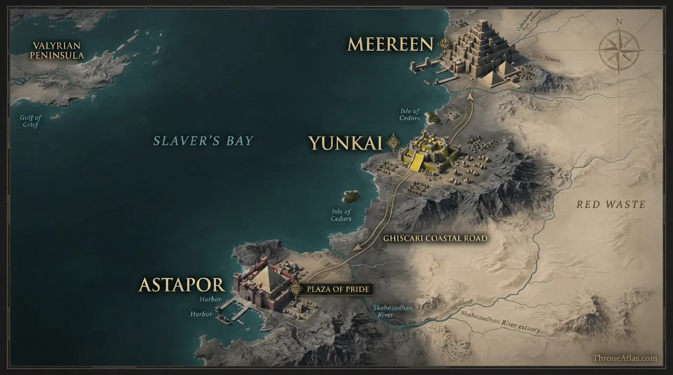
Grey Worm’s published-book journey is concentrated in Slaver’s Bay. He begins as one of the Unsullied sold in Astapor, is chosen as commander after Daenerys frees the army, marches north along the Ghiscari coastal route to Yunkai, and continues to Meereen. There he becomes central to the city’s defense, the war against the Sons of the Harpy, refugee relief outside the walls and preparations for the second siege. Unlike the television adaptation, the published novels have not yet taken Grey Worm to Dragonstone or King’s Landing.
Key Takeaways
Astapor
This page maps confirmed character locations in sequence and labels broad travel corridors separately from fully documented stops.
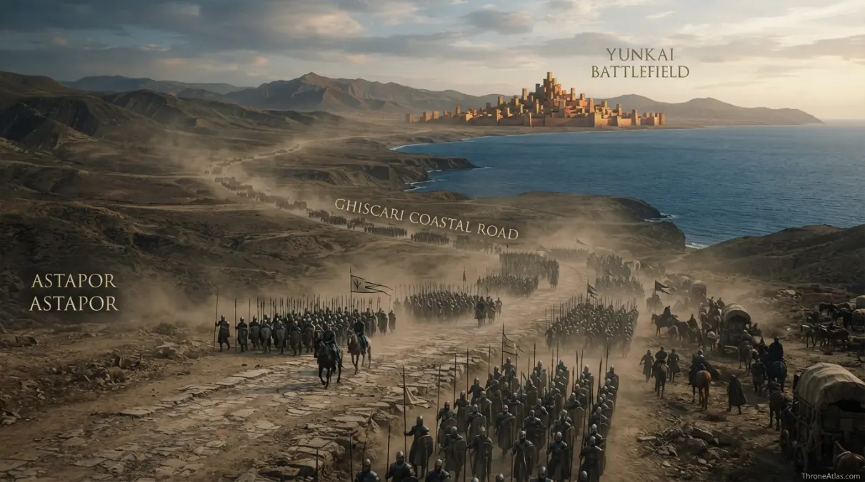
Plaza of Pride, Ghiscari coastal road and Yunkai battlefield
Confirmed locations are separated from reconstructed corridors.
Second siege positions
Maintained for 2026.
Visual Atlas
Each point explains why the location belongs on the atlas.
Mapped Locations and Confidence
| Location / Zone | Confidence | Why it belongs on the map |
|---|---|---|
| 1. Astapor | High | Grey Worm begins the mapped story among the Unsullied of Astapor and is freed when Daenerys turns the army against the Good Masters. |
| 2. Plaza of Pride | High | The transaction for the Unsullied and Daenerys’s seizure of Astapor make the plaza a key local anchor in Grey Worm’s transformation from slave soldier to chosen commander. |
| 3. Ghiscari coastal road | High | Daenerys’s host travels north from Astapor toward Yunkai along the Slaver’s Bay corridor. |
| 4. Yunkai battlefield | High | Grey Worm commands Unsullied in the battle outside Yunkai, helping defeat the city’s forces with remarkably low losses. |
| 5. Road to Meereen | High | The army continues north from Yunkai toward Meereen, the third great slaver city of the campaign. |
| 6. Meereen | High | Grey Worm becomes one of Daenerys’s most important commanders and remains centered in Meereen through A Dance with Dragons. |
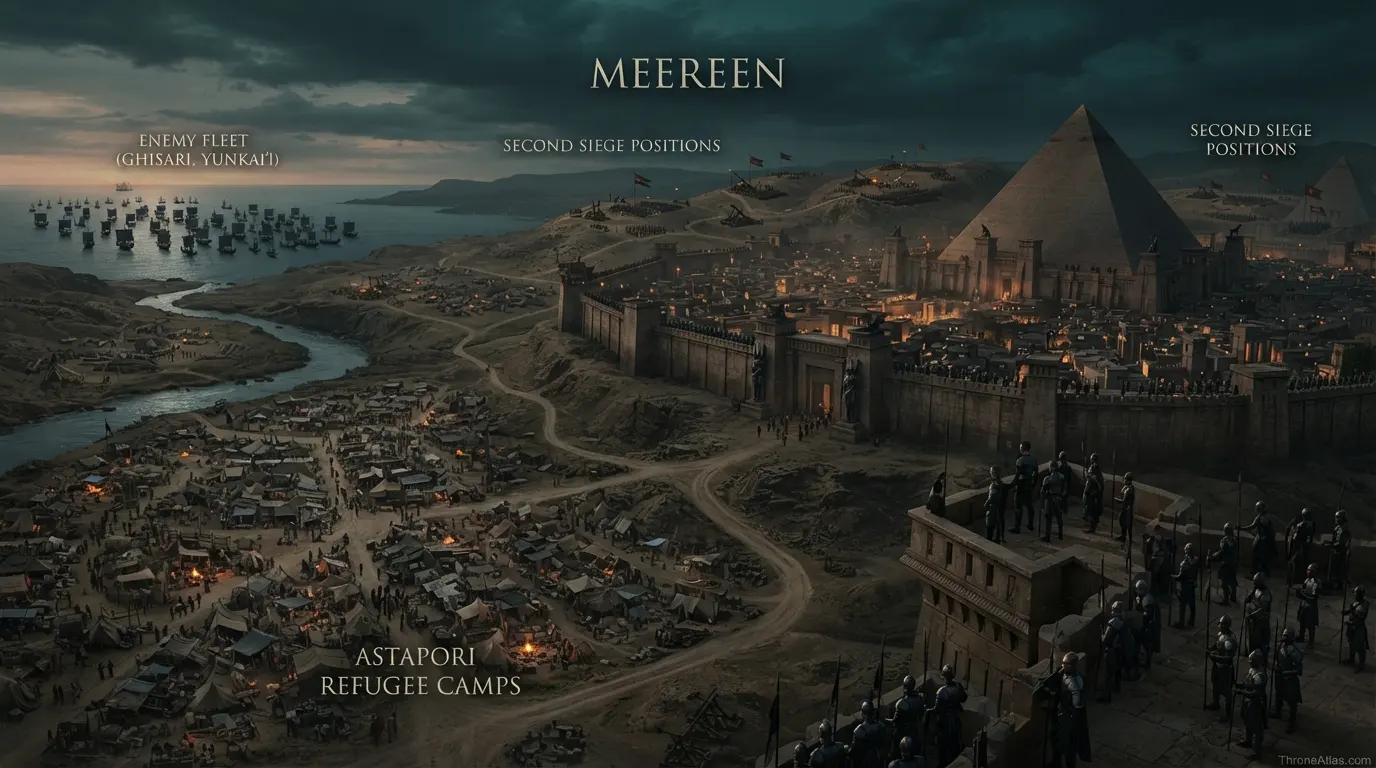
| 7. Astapori refugee camps | High | Grey Worm and fifty Unsullied help refugees outside Meereen’s walls during the bloody flux crisis. |
| 8. Second siege positions | High | Grey Worm remains a commander of the Unsullied as enemy armies and fleets encircle Meereen, making the city’s walls and siege perimeter the current endpoint of his book-canon map. |
1. Astapor
Grey Worm begins the mapped story among the Unsullied of Astapor and is freed when Daenerys turns the army against the Good Masters. This marker is useful because it fixes the page to a named place, terrain feature or documented route relationship. It should be read with the surrounding anchors rather than as an isolated coordinate.
2. Plaza of Pride
The transaction for the Unsullied and Daenerys’s seizure of Astapor make the plaza a key local anchor in Grey Worm’s transformation from slave soldier to chosen commander. This marker is useful because it fixes the page to a named place, terrain feature or documented route relationship. It should be read with the surrounding anchors rather than as an isolated coordinate.
3. Ghiscari coastal road
Daenerys’s host travels north from Astapor toward Yunkai along the Slaver’s Bay corridor. This marker is useful because it fixes the page to a named place, terrain feature or documented route relationship. It should be read with the surrounding anchors rather than as an isolated coordinate.
4. Yunkai battlefield
Grey Worm commands Unsullied in the battle outside Yunkai, helping defeat the city’s forces with remarkably low losses. This marker is useful because it fixes the page to a named place, terrain feature or documented route relationship. It should be read with the surrounding anchors rather than as an isolated coordinate.
5. Road to Meereen
The army continues north from Yunkai toward Meereen, the third great slaver city of the campaign. This marker is useful because it fixes the page to a named place, terrain feature or documented route relationship. It should be read with the surrounding anchors rather than as an isolated coordinate.
6. Meereen
Grey Worm becomes one of Daenerys’s most important commanders and remains centered in Meereen through A Dance with Dragons. This marker is useful because it fixes the page to a named place, terrain feature or documented route relationship. It should be read with the surrounding anchors rather than as an isolated coordinate.
7. Astapori refugee camps
Grey Worm and fifty Unsullied help refugees outside Meereen’s walls during the bloody flux crisis. This marker is useful because it fixes the page to a named place, terrain feature or documented route relationship. It should be read with the surrounding anchors rather than as an isolated coordinate.
8. Second siege positions
Grey Worm remains a commander of the Unsullied as enemy armies and fleets encircle Meereen, making the city’s walls and siege perimeter the current endpoint of his book-canon map. This marker is useful because it fixes the page to a named place, terrain feature or documented route relationship. It should be read with the surrounding anchors rather than as an isolated coordinate.
Grey Worm’s route follows the Slaver’s Bay spine
Astapor, Yunkai and Meereen form a clear south-to-north sequence along the bay. The route is unusually map-friendly because the cities are linked by the old Ghiscari coastal road and described with relative distances.
Astapor is both origin and liberation
Grey Worm’s first mapped location carries two opposite meanings. It is where the Unsullied system dehumanized soldiers and where Daenerys breaks their legal enslavement. The geography does not change, but Grey Worm’s relationship to the place does.
Yunkai shows command in the field
Outside Yunkai, Grey Worm is no longer simply one soldier in formation. He commands Unsullied as part of a coordinated battle plan. The location marks his emergence as a military leader.
Meereen expands his role beyond battle
In Meereen, Grey Worm guards the queen, responds to insurgent violence, helps organize freedmen and assists sick refugees outside the walls. His map becomes urban and humanitarian as well as military.
Why Dragonstone and King’s Landing are not on the main route
The HBO adaptation eventually brings Grey Worm to Westeros. The novels published so far do not. Combining those paths without a label would create a false book route, so this page keeps adaptation geography separate.
A character route is not a GPS track
The novels usually establish major destinations and travel corridors, not every camp, bridge or night’s lodging. ThroneAtlas therefore connects firm anchors with broad route bands where needed instead of converting narrative gaps into precise lines.
Political purpose changes the meaning of travel
The same road or sea lane can carry a royal progress, diplomatic ward, military host or outlaw band. The geography stays stable while the reason for movement changes. That contrast is often the most important insight on a character map.
Book canon and adaptation geography stay separate
Where the television adaptation sends a character beyond the locations reached in the published novels, the main atlas does not silently merge the two. Screen-only movements can be discussed as adaptation context, but they are not presented as book-canon stops.
How to read the Grey Worm Journey Map
Begin with Astapor, then locate Yunkai battlefield and finally zoom out toward Second siege positions. Those three points create a practical framework: origin or seat, a geographic turning point, and the wider regional connection. The sequence makes the map readable even for someone who remembers the story better than the geography.
This page maps confirmed character locations in sequence and labels broad travel corridors separately from fully documented stops.
The map also separates permanent geography from temporary control. Roads, rivers and castles usually remain where they are while armies, rulers and alliances change around them. Keeping those layers distinct lets the same atlas support several periods without rewriting the underlying world.
Distance, travel and realistic movement
Fantasy maps are easy to overread. A straight line between two dots may look like the obvious route, but travelers follow roads, armies seek crossings and food, ships use navigable coasts, and hidden bands deliberately avoid predictable paths. The atlas therefore shows direction and sequence first, exact path only when the source truly supports it.
Travel time is treated with the same caution. When the books give a specific duration—such as the short ride between Cerwyn and Winterfell—it is useful evidence. Where no travel time is stated, this page avoids converting map scale into an unsupported number of days.
What the map reveals that a plot summary misses
A plot summary tells us what happened. A map reveals why certain places repeatedly become important. Neighboring houses compete because their lands touch. A king’s road funnels travelers through the same corridor. A river ford becomes a battlefield because armies need to cross. A hidden cave protects outlaws because conventional castles are too visible.
Once those relationships are visible, apparently separate scenes connect. Astapor and Second siege positions no longer feel like names from different chapters; they become points inside one geographic system.
Confirmed geography versus reconstruction
High-confidence markers come directly from published maps or explicit narrative placement. Medium-confidence markers usually represent one of two cases: the broad region is firm but the exact spot is not, or a source outside the main novels adds a plausible placement that should not be treated as equal to primary canon. Low confidence is reserved for genuinely unresolved points.
This approach matters because map graphics are persuasive. Once a dot appears in a polished visual, readers naturally assume somebody measured it. ThroneAtlas uses labels to make the evidence visible instead of hiding uncertainty behind design.
Fast answers from this atlas
Start here
Astapor is the strongest first anchor for understanding the page.
Turning point
Yunkai battlefield changes the geographic or political meaning of the route.
Wider connection
Second siege positions links this page into the larger ThroneAtlas network.
Regional field notes
Scale is especially important on this page. A local event may happen within a few miles while its consequences reshape an entire kingdom. Conversely, a long journey may pass quickly in the narrative because the story focuses only on the endpoints. The atlas restores the spatial layer without pretending that every blank interval contains known detail.
Political geography should also be read as temporary. A castle may be Stark, Bolton, Lannister, Baratheon or rebel-controlled at different moments without moving. For that reason, the page avoids coloring permanent terrain as though one wartime occupation were eternal.
Readers comparing multiple pages should find the same anchor in the same broad relationship. Winterfell remains north of the Cerwyn river zone; the Twins still control the Green Fork crossing; Astapor remains south of Yunkai and Meereen. Consistency across pages is one of the core purposes of a connected atlas.
Why this page is useful for lore research
Grey Worm’s published-book journey is concentrated in Slaver’s Bay. He begins as one of the Unsullied sold in Astapor, is chosen as commander after Daenerys frees the army, marches north along the Ghiscari coastal route to Yunkai, and continues to Meereen. There he becomes central to the city’s defense, the war against the Sons of the Harpy, refugee relief outside the walls and preparations for the second siege. Unlike the television adaptation, the published novels have not yet taken Grey Worm to Dragonstone or King’s Landing.
That short answer gives the sequence, but the full page adds evidence and limits. A researcher can quickly see which places are firm, where a route is reconstructed and what related maps provide the next layer of context. The goal is not to overwhelm the story with cartography; it is to make the story’s geography easier to verify.
Atlas interpretation: center, corridor and edge
Most useful fantasy maps can be reduced to three spatial roles. The center is where authority or identity is strongest. The corridor is the road, river, sea lane or campaign zone that enables movement. The edge is where certainty, influence or the narrative itself begins to fade. On this page those roles can be read through Astapor, Yunkai battlefield and Second siege positions.
Thinking in those terms prevents two common mistakes. First, it stops every named place from being treated as equally important. Second, it prevents the blank spaces between places from being filled with invented detail simply because the design looks cleaner with a continuous line.
Connecting this page to the wider ThroneAtlas
The fastest way to deepen this map is to change scale. Open the regional map for distance and terrain, a battle map for temporary control, a house page for political allegiance, or another character route for a different perspective on the same road. The geographic anchors should remain consistent even when the story layer changes.
That connected structure also keeps this page focused. It does not need to retell every event involving the subject. Its job is to explain where the major events sit, how they connect and which parts of the route are certain enough to draw confidently.
Additional atlas notes for Grey Worm Journey Map
A connected map becomes more reliable when it keeps three questions separate: where is the subject, how did people move through the surrounding geography, and who controlled the area at a particular moment? Those answers can overlap, but they are not identical. A castle can remain fixed while its allegiance changes; a road can stay open while an army chooses another route; a character can pass through a region without ruling it.
This page therefore uses physical anchors before political coloring. Rivers, roads, coastlines, forests, walls and named settlements provide the stable framework. Political control and narrative movement are added as layers on top. That structure makes the map easier to compare with other ThroneAtlas pages set in different years.
Where a source gives direction but not exact distance, the atlas preserves direction. Where it gives a destination but not every intermediate stop, the atlas preserves the corridor. Where sources disagree, the disagreement is stated. These choices may look less absolute than a fan reconstruction, but they make the map more dependable for readers who want to know what is actually supported.
The three image positions serve different jobs: the hero establishes atmosphere and region, the main atlas should carry the finished geographic visual, and the contextual image can focus on the most important route, castle, battle zone or regional relationship. Their alt text is written to describe the image purpose rather than repeat the title mechanically.
Map Accuracy and Canon Confidence
High confidence means a place or relationship is directly established in published geography or narrative. Medium confidence marks a strong regional reconstruction or secondary-source placement. Low confidence is used where the existence of a place is known but its exact position is not.
ThroneAtlas does not draw exact borders or route lines merely to make the graphic look complete. Where the source stops, the certainty stops too.
Source Basis
This atlas follows Grey Worm in A Storm of Swords and A Dance with Dragons. The route is book-canon first: Astapor, Yunkai and Meereen. Later HBO locations are not merged into the main line.
The page is an interpretive atlas built to answer practical questions about location, sequence, neighboring geography and map confidence. It does not substitute reconstruction for missing canon.
Frequently Asked Questions
Where does the Grey Worm journey map begin?
The first major anchor is Astapor. From there the page follows the best-supported regional or chronological sequence.
What is the most important location on this map?
Astapor is the primary orientation point, while Yunkai battlefield is especially useful for understanding how the geography changes across the page.
Is the Grey Worm journey map based on the books?
Yes. The main route and geography use published book canon and world maps. Adaptation-only locations are not silently blended into the sequence.
Are all route lines exact?
No. Confirmed places are separated from inferred corridors. The map does not invent an exact road, flight path or march where the text only gives start and end points.
What do the confidence labels mean?
High marks directly established geography. Medium marks a strong regional reconstruction or semi-canon placement. Low is used where an exact location remains unresolved.
Why are neighboring regions shown?
They provide scale and explain political or strategic relationships. Showing a neighbor does not imply ownership or a confirmed visit.
Can I use this map to calculate exact miles?
No. The visual atlas is designed for relative position, sequence and story geography rather than modern survey measurements.
Which ThroneAtlas page should I open after Grey Worm Journey?
The Continue Exploring section links to the strongest regional, battle, house and journey maps that share the same geographic anchors.
Why is some information deliberately uncertain?
Because the source material itself is uneven. Preserving uncertainty is more accurate than filling gaps with popular fan-map assumptions.
When was this Grey Worm journey map updated?
This page is maintained as a 2026 edition and uses the year rather than a fixed day-and-month freshness stamp.