King’s Landing Gates Map: All Seven Entrances, Roads & Strategic Routes
A gate-by-gate atlas of the capital’s walls, roads and waterfront approaches — built to show how people, armies and supplies actually move through King’s Landing.
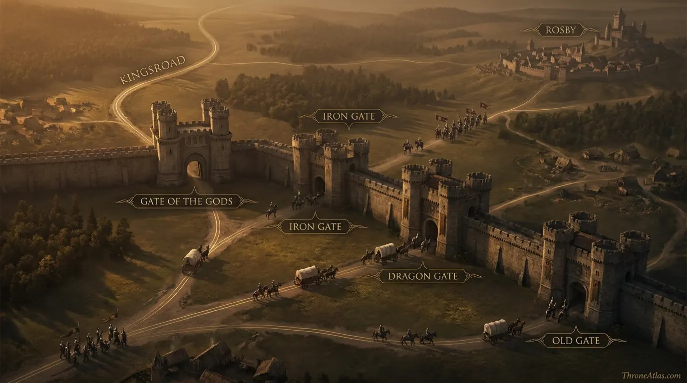
King’s Landing has seven named city gates: the Dragon Gate, Iron Gate, Old Gate, Gate of the Gods, River Gate (also called the Mud Gate), Lion Gate and King’s Gate. Their importance comes from the roads, markets, wharfs and military approaches they connect to, not simply their positions in the wall.
Seven Gates, Seven Different Ways Into the Capital
Use the markers to read the capital as a network. The northern and western gates connect the city to major land roads, while the River Gate faces the commercial life of the Blackwater waterfront. The Red Keep is included as an internal anchor so the wall entrances make sense in relation to the seat of royal power.
Canon Confidence & What This Map Claims
ThroneAtlas separates confirmed geography from useful reconstruction so a clean digital map never appears more certain than the underlying source.
Read the Map From Anchors to Story
- Visual Atlas
- Canon Confidence
- Key Takeaways
- Locations & Route Table
- Why the Seven Gates Matter More Than a Single City Wall
- Northern and Eastern Gates: Kingsroad, Rosby and the Landward Face
- The River Gate: Where the City Meets Blackwater Bay
- Western Approaches: Lion Gate, King’s Gate and the Goldroad
- Gates During Siege, Riot and Supply Crisis
- How to Read the Gate Geography Without Inventing Streets
- Fast Answers
- Sources & Method
- FAQs
What the Gate Map Reveals at a Glance
The walls are a transport system
A city gate is not just a defensive hole in stone. Each gate channels a different road, crowd and type of traffic into the capital.
The River Gate is commercial
Its proximity to the Blackwater wharfs makes it inseparable from fish markets, ships, dock labor and wartime naval pressure.
The Gate of the Gods faces the kingsroad
This makes the northern approach especially important for travelers and forces arriving from the Riverlands and farther north.
The Iron Gate points toward Rosby
Its road connection helps place King’s Landing within the wider Crownlands rather than treating the capital as an isolated city.
The Lion Gate reads west
The western gate is naturally understood beside the Goldroad and the overland connection to the Westerlands.
The King’s Gate serves another western-southern approach
Its significance becomes clearer when read beside the tourney grounds and the open land outside the walls.
Siege changes gate importance
A peaceful entrance can become a choke point, sortie route or pressure point when armies or refugees crowd the capital.
Exact street geometry is partly uncertain
Canon gives enough anchors to map function and direction, but not a modern cadastral plan of every wall segment.
Places, Routes & Strategic Connections
| Map Anchor | Type | Why It Matters |
|---|---|---|
| Dragon Gate | Gate | A northeastern entrance associated with the city’s landward side and routes leaving the capital. |
| Iron Gate | Gate | A major eastern/northeastern gate on the road toward Rosby and the Crownlands beyond. |
| Old Gate | Gate | One of the old eastern approaches through the city wall, useful for reading the capital’s crowded outer movement. |
| Gate of the Gods | Gate | The northern gate tied to the kingsroad approach and one of the most important land entrances. |
| River Gate / Mud Gate | Gate | The waterfront gate near Fishmonger’s Square and the Blackwater wharfs, central to trade and battle movement. |
| Lion Gate | Gate | A western gate associated with the Goldroad approach from the Westerlands. |
| King’s Gate | Gate | A southwestern entrance near the tourney grounds and approaches south and west of the city. |
| Red Keep | Landmark | The royal fortress on Aegon’s High Hill, included as the internal political anchor of the city. |
Why the Seven Gates Matter More Than a Single City Wall
Most maps of King’s Landing understandably emphasize the Red Keep, the three great hills and Blackwater Bay. That makes the city recognizable, but it can hide the feature that governs daily movement most directly: the wall has only a limited number of controlled openings. Anyone bringing grain, livestock, weapons, news, pilgrims, noble retinues or soldiers into the capital has to pass through one of those entrances. The gates therefore transform a continuous wall into a set of strategic decisions.
That distinction matters because King’s Landing is not laid out like a modern planned capital. It grew quickly after Aegon’s Conquest and became crowded, irregular and socially divided. A traveler’s experience of the city depends on where they arrive. Entering from the kingsroad is not the same as coming off a ship near the Blackwater. A western lord approaching on the Goldroad does not encounter the same outer terrain as a Crownlands household coming from Rosby. The gate map converts those differences into readable geography.
The gates also explain why the capital can become dangerously congested during war. Closing a gate protects the wall but also interrupts food, trade and civilian movement. Opening it can admit supplies while exposing defenders to infiltration or assault. In a city that depends on surrounding farmland and sea traffic, wall security and urban survival are constantly in tension.
For ThroneAtlas, the useful question is therefore not “where is the wall?” but “what does each opening connect?” Once the seven entrances are treated as nodes in a transport network, scenes involving crowds, patrols, armies and royal movement make more geographical sense. The city stops being a decorative backdrop and becomes what it is in the story: a compressed political machine whose access points can determine what happens inside.
Northern and Eastern Gates: Kingsroad, Rosby and the Landward Face
The Gate of the Gods and Iron Gate are especially useful for understanding the capital’s relationship with the Crownlands and the wider road network. The Gate of the Gods is associated with the northern approach and the kingsroad, the great overland artery that continues through the Riverlands and ultimately toward the North. That makes it more than an architectural landmark. It is one of the places where the vast geography of Westeros narrows into the streets of a single city.
The Iron Gate, farther around the landward wall, is tied to the road toward Rosby. Rosby matters because it sits close enough to King’s Landing to function as part of the capital’s immediate strategic landscape. When food supplies, refugees or armies move through the Crownlands, roads like this become practical arteries. A map that shows only Rosby and King’s Landing as two dots misses the decisive middle step: the gate through which traffic must actually enter the fortified city.
The Dragon Gate and Old Gate complete the eastern side’s network. Their exact street relationships are not exhaustively measured in canon, and a responsible atlas should resist drawing false precision. What can be shown confidently is that these entrances distribute movement along the city’s landward arc instead of forcing everything through a single northern portal.
This becomes particularly important during crisis. Defenders can assign watches, close vulnerable entrances and redirect traffic. Attackers must choose whether to invest the walls broadly or concentrate on a known approach. Messengers and scouts care about the fastest road into the city, while civilians care about which gates remain open. In narrative terms, the gates are where the political geography of the Crownlands physically touches the urban geography of King’s Landing.
The River Gate: Where the City Meets Blackwater Bay
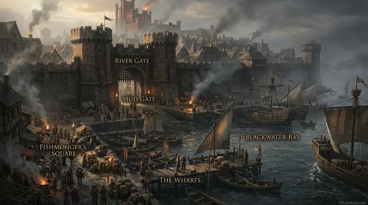
The River Gate — commonly called the Mud Gate — is the clearest example of a gate whose identity comes from what lies outside it. It opens toward the Blackwater waterfront, near Fishmonger’s Square and the busy riverfront world of quays, boats, warehouses and markets. That makes it one of the capital’s most vivid economic thresholds.
In peacetime, the gate connects urban consumers with food and goods arriving by water. Fish, cargo and travelers move between ships and streets. The smell, noise and crowding of the waterfront are part of the gate’s character. In wartime, the same openness becomes dangerous. The Blackwater is not merely scenery beside King’s Landing; it is an avenue by which fleets can threaten the capital and defenders can project force.
The Battle of the Blackwater makes this geography impossible to ignore. Stannis Baratheon’s assault approaches the city from the river, while the defenders use the waterfront, walls and wildfire as parts of one connected defensive system. The Mud Gate becomes meaningful because it stands close to the place where naval battle and urban defense collide. The gate’s function cannot be separated from the river.
This also explains why Flea Bottom, the wharfs and the lower eastern districts deserve to be mapped together rather than as isolated attractions. Poor residents, dockworkers, market traffic and soldiers move through overlapping spaces. A single gate may serve people with radically different purposes: a fisherman carrying the morning catch, a gold cloak on patrol, a merchant unloading cargo or a knight racing toward a battle line.
On this atlas, the River Gate is therefore treated as a transport and social node, not merely a named opening. Its position helps users understand why the Blackwater shapes daily life in King’s Landing just as strongly as the Red Keep shapes political life.
Western Approaches: Lion Gate, King’s Gate and the Goldroad
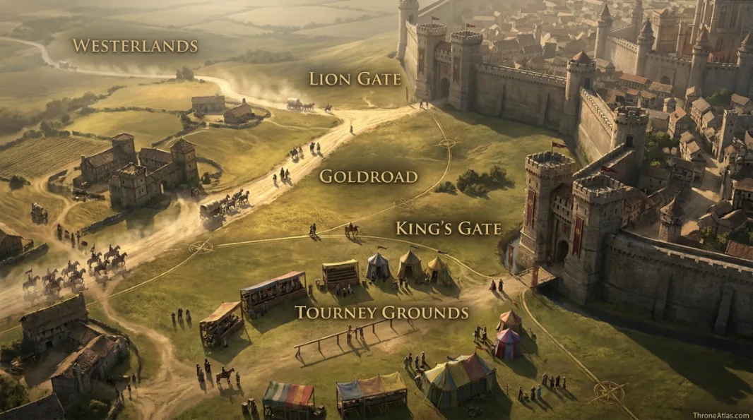
The western side of King’s Landing opens toward the roads and fields that connect the capital with the Westerlands, the Reach and other regions to the south and west. The Lion Gate is the clearest symbolic link to that direction because it is associated with the Goldroad, the major route running toward the Westerlands. That connection gives the gate strategic weight whenever Lannister forces, western commerce or relief armies approach the city.
The King’s Gate lies farther along the southwestern wall and is associated with the tourney grounds outside the city. This is a different kind of edge space. Tourneys need open land that crowded King’s Landing cannot provide inside its walls, so the gate creates a transition from dense urban streets to broad exterior ground. Ceremonial movement and military movement can therefore use some of the same approaches for very different reasons.
Reading both gates together helps correct a common mental picture in which all important travel happens along the kingsroad north of the city. King’s Landing is a hub with several spokes. The Goldroad matters, the Rosby road matters, the Blackwater matters, and local Crownlands tracks matter. The seven-gate system distributes these routes around the walls.
This western geography becomes decisive near the end of the Battle of the Blackwater. Relief forces arriving from the west and south alter the battle’s outcome. The exact tactical path of every contingent should not be reduced to a single neat line, but the broader lesson is clear: whoever controls the approaches around the capital can change events inside it.
For map readers, the Lion Gate and King’s Gate are best understood as paired western thresholds. They show how court spectacle, regional roads and military logistics meet at the edge of the same city.
Gates During Siege, Riot and Supply Crisis
A gate map becomes most useful when the city is under pressure. King’s Landing repeatedly faces food shortages, political unrest, military threats and sudden changes in who controls the roads outside the walls. During those moments, each gate can become a bottleneck. The same architecture that keeps enemies out can trap hunger and fear inside.
Food is the simplest example. A capital of this size cannot feed itself from gardens within the walls. Grain, livestock and other supplies have to arrive from surrounding regions or by ship. If hostile armies cut roads, if fleets block the Blackwater or if authorities restrict movement, the effect is felt in markets and neighborhoods far from the fighting. Gates are therefore part of the city’s food system.
Crowds create a second kind of pressure. Refugees may seek safety inside the walls while nervous rulers fear spies, disease or disorder. Gold cloaks and soldiers can control entrances, but control is never frictionless. Searching wagons, questioning travelers and closing gates slows the movement on which the city depends.
In an assault, the logic changes again. Gates are potential weak points because they interrupt continuous masonry, yet they are also heavily defended for exactly that reason. Attackers may threaten them directly, use siege engines elsewhere to force defenders to spread out, or try to create panic that causes an entrance to fail from within.
The map should therefore be read dynamically. A gate that is politically quiet in one chapter can become the center of a crisis in another. Its strategic value depends on who controls the road outside, what supplies need to pass through, where the enemy is positioned and whether the population trusts the people guarding it. That changing function is more important than any decorative reconstruction of the gatehouse itself.
How to Read the Gate Geography Without Inventing Streets
King’s Landing has appeared in novels, official maps, television production designs and fan reconstructions, and those sources do not always provide a single perfectly scalable plan. The safe way to map the gates is to distinguish directional relationships from exact coordinates.
High-confidence information includes the existence and names of the seven gates, the association of major entrances with roads such as the kingsroad, Rosby road and Goldroad, and the River Gate’s relationship with the Blackwater waterfront. The Red Keep’s position on Aegon’s High Hill also provides a strong internal anchor.
Moderate-confidence reconstruction begins when we place all seven entrances on one clean digital outline and estimate spacing so the city remains legible. That is useful, but users should not mistake the schematic for a survey commissioned by the crown. Canon does not tell us the exact number of paces between every gate, the width of every approach road or the alignment of every minor alley.
This distinction matters for searchers who want to answer practical questions. “Which gate connects to the kingsroad?” can be answered directly. “How many meters separate the Iron Gate and Dragon Gate?” cannot. “Which gate is closest to the Blackwater wharfs?” has a meaningful answer in the River Gate. “What exact latitude is the Old Gate?” does not.
ThroneAtlas therefore uses the map as an explanatory model. It preserves the relationships that matter to the story while labeling uncertainty around details the text never fixes. That approach makes the page more useful than either extreme: a vague list of gate names with no geography, or a beautiful but falsely precise city plan that quietly turns fan interpretation into fact.
Fast Answers About the Map
The fortified city is described with seven named gates around its walls.
The Gate of the Gods is the key northern entrance associated with the kingsroad approach.
The Iron Gate is associated with the road toward Rosby and the Crownlands northeast of the capital.
The River Gate, commonly called the Mud Gate, serves the waterfront near Fishmonger’s Square and the wharfs.
The Lion Gate is the major western entrance associated with the Goldroad toward the Westerlands.
No. They are separate entrances on different parts of the wall.
No. Their directional relationships are canon-based, while exact spacing is schematic where the sources do not provide surveyed measurements.
They are controlled openings in the city wall, making them important for supplies, sorties, civilian movement and potential assault routes.
What This Atlas Is Based On
- George R. R. Martin’s A Song of Ice and Fire novels for city movement, gate names and battle context.
- The World of Ice & Fire and published reference material for the capital’s broad geography and Crownlands connections.
- Officially published maps and adaptation geography are used as supporting visual references where they do not conflict with the written canon.
- Where exact urban measurements are absent, this atlas preserves directional relationships and labels the layout as schematic.
Continue Exploring ThroneAtlas Maps
King’s Landing Gates Map FAQs
What are the seven gates of King’s Landing?
The named gates are the Dragon Gate, Iron Gate, Old Gate, Gate of the Gods, River Gate or Mud Gate, Lion Gate and King’s Gate.
Which gate does the kingsroad enter through?
The kingsroad is associated with the Gate of the Gods on the northern side of King’s Landing.
Why is the River Gate called the Mud Gate?
The River Gate is commonly known as the Mud Gate, reflecting its lower waterfront setting near the Blackwater and busy river traffic.
Which gate is used for the Goldroad?
The Lion Gate is the principal western entrance associated with the Goldroad toward the Westerlands.
Where is the Iron Gate?
It is on the landward eastern/northeastern side of the city and is associated with the road toward Rosby.
Is the Red Keep one of the city gates?
No. The Red Keep is the royal fortress inside King’s Landing. It is shown here only as an internal orientation point.
Were all seven gates attacked in the Battle of the Blackwater?
No. The battle focused heavily on the Blackwater waterfront and the city’s southern and river-facing defenses rather than an equal assault on every gate.
Can you walk directly from one gate to another inside the city?
The gates are connected by King’s Landing’s street network, but the exact modern-style routing and distances are not fully specified in canon.
Are the gate locations the same in the books and HBO series?
The broad city functions are recognizable across versions, but production geography and visual layout should not be treated as a perfect one-to-one survey of the novels.
Why map the gates separately from the King’s Landing map?
A dedicated gate atlas makes road connections, military bottlenecks and waterfront access visible in a way a general city overview cannot.
Why This Geography Matters
The seven gates explain how King’s Landing breathes. They connect the walled capital to the kingsroad, Rosby, the Goldroad, Blackwater shipping and the open ground beyond the walls. Mapping those entrances turns the city from a static landmark into a network of trade, defense and political movement.