Tourney at Harrenhal Map: Rhaegar, Lyanna & the Year of the False Spring
A convergence map of the great tourney at Harrenhal, where princes, Starks, Kingsguard, great lords and one enduring mystery gathered beside the Gods Eye during the year of the false spring.
Read the Map by Place, Route and Confidence
Interactive Tourney at Harrenhal Map: Rhaegar, Lyanna & the Year of the False Spring
This schematic is a reading aid, not an official cartographic plate. Tap a marker to see why that location matters. The connecting route is intentionally simplified so confirmed geography is not confused with an invented exact path.
Map Navigator
Six Things the Map Makes Clear
1. Map Takeaway
The map is built around event convergence and tournament grounds, not a generic Westeros overview.
2. Map Takeaway
Confirmed places are separated from reconstructed corridors so the page does not overstate precision.
3. Map Takeaway
The strongest geographic anchors are Harrenhal, Gods Eye and Weirwood / Mystery Zone.
4. Map Takeaway
Political, military and environmental geography are explained together instead of being reduced to a pin list.
5. Map Takeaway
Book chronology and adaptation material are kept separate whenever they do not align exactly.
6. Map Takeaway
The map is designed to connect naturally with the surrounding ThroneAtlas location, house, battle and journey pages.
Key Places on the Tourney At Harrenhal Map
| Location | Map confidence | Why it matters |
|---|---|---|
| Harrenhal | Confirmed center | The enormous riverlands castle that hosted the tourney. |
| Gods Eye | Confirmed geography | The great lake beside Harrenhal and the most important natural landmark for orientation. |
| Kingsroad | Regional corridor | Major north–south travel route helping explain access to the central riverlands. |
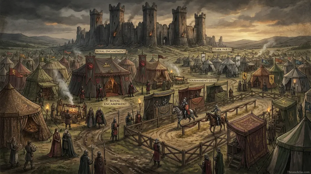
| Royal Encampment | Reconstructed zone | The king and court attended; exact tent positions are not preserved. |
| Tournament Lists | Reconstructed zone | The jousts required formal lists, but no canonical detailed plan survives. |
| Stark Party | Event node | Rickard’s children and companions are central to several remembered episodes. |
| Howland Reed Encounter | Narrative node | The crannogman’s mistreatment and Lyanna’s intervention underpin the mystery-knight tradition. |
| Weirwood / Mystery Zone | Interpretive | Associated with the Knight of the Laughing Tree story; exact physical spot is unknown. |
A location marked “reconstructed” is not a guess presented as fact. It means the surrounding event is attested but the surviving narrative does not give enough spatial detail to place a modern-style coordinate. That distinction is especially important for ancient battles, aerial pursuits, siege camps and long sea voyages.
How the Story Moves Across the Map
Why Harrenhal was a perfect gathering point
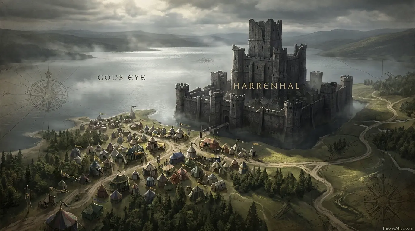
Harrenhal sits in the central riverlands beside the Gods Eye, close to routes that connect north, south, east and west. Its enormous ruins can host a gathering on a scale smaller castles could not easily absorb. That makes the event geographically believable: this is a place where royal progress, northern nobles, stormlords, riverlords and Dornish royalty can converge. The map should emphasize access and concentration rather than pretend the surviving text provides a modern tournament-site plan.
From an atlas perspective, this section is best read through the relationship between Harrenhal and Kingsroad. The first anchors the narrative in a named place, while the second shows how the consequences spread into a wider political or military space. That relationship is more useful than forcing the episode into an artificial straight line, because Westerosi history is shaped by roads, seas, fortifications, weather, alliances and the time required to move information as much as by raw distance.
The castle and the temporary city around it
A major tourney is more than a set of jousting lists. It requires pavilions, horses, kitchens, guards, noble households, merchants, spectators and spaces for feasts. Harrenhal’s scale makes that temporary social world possible. None of the principal sources gives exact tent coordinates, so the atlas uses broad event zones. That preserves the useful spatial insight—the castle becomes a short-lived capital of the nobility—without turning reconstruction into fake canon.
From an atlas perspective, this section is best read through the relationship between Gods Eye and Royal Encampment. The first anchors the narrative in a named place, while the second shows how the consequences spread into a wider political or military space. That relationship is more useful than forcing the episode into an artificial straight line, because Westerosi history is shaped by roads, seas, fortifications, weather, alliances and the time required to move information as much as by raw distance.
Lyanna Stark, Howland Reed and the Laughing Tree mystery
One of the tourney’s most memorable traditions begins with Howland Reed being bullied by squires and Lyanna defending him. The later appearance of the mysterious Knight of the Laughing Tree has led readers to connect Lyanna with the disguised knight, but the identity is not explicitly confirmed in the text. A map can place the Stark party, feasting areas and tournament space in relation to each other while still marking the mystery as a theory rather than a solved coordinate puzzle.
From an atlas perspective, this section is best read through the relationship between Kingsroad and Tournament Lists. The first anchors the narrative in a named place, while the second shows how the consequences spread into a wider political or military space. That relationship is more useful than forcing the episode into an artificial straight line, because Westerosi history is shaped by roads, seas, fortifications, weather, alliances and the time required to move information as much as by raw distance.
Rhaegar’s victory creates the most famous point on the map
Rhaegar wins the joust and then rides past his wife, Elia Martell, to place the queen of love and beauty’s crown in Lyanna Stark’s lap. The gesture is small in physical distance and enormous in historical memory. It places the prince, his wife, Lyanna, Robert Baratheon and the watching nobility in one public scene. That is why the tournament lists are the central event marker even though their exact footprint within Harrenhal’s vast grounds is uncertain.
From an atlas perspective, this section is best read through the relationship between Royal Encampment and Stark Party. The first anchors the narrative in a named place, while the second shows how the consequences spread into a wider political or military space. That relationship is more useful than forcing the episode into an artificial straight line, because Westerosi history is shaped by roads, seas, fortifications, weather, alliances and the time required to move information as much as by raw distance.
Politics beneath the pageantry
The tourney has long attracted theories that Rhaegar or powerful lords intended it as cover for political discussion about Aerys II. King Aerys’s unexpected attendance changes the atmosphere. Those motives remain partly interpretive, so a careful atlas separates confirmed presence from inferred conspiracy. What can be mapped with confidence is the unusual concentration of people who later occupy opposite sides of Robert’s Rebellion.
From an atlas perspective, this section is best read through the relationship between Tournament Lists and Howland Reed Encounter. The first anchors the narrative in a named place, while the second shows how the consequences spread into a wider political or military space. That relationship is more useful than forcing the episode into an artificial straight line, because Westerosi history is shaped by roads, seas, fortifications, weather, alliances and the time required to move information as much as by raw distance.
How Harrenhal becomes a pre-rebellion map
The event matters because later history makes every relationship at the tourney look prophetic. Brandon and Eddard Stark are present; Robert Baratheon is tied to Lyanna; Rhaegar is married to Elia; Aerys watches his son with suspicion; Kingsguard and great lords mingle nearby. The tourney does not itself cause every later event, but it compresses the coming crisis into one location. Few places in Westeros contain so many future fault lines at once.
From an atlas perspective, this section is best read through the relationship between Stark Party and Weirwood / Mystery Zone. The first anchors the narrative in a named place, while the second shows how the consequences spread into a wider political or military space. That relationship is more useful than forcing the episode into an artificial straight line, because Westerosi history is shaped by roads, seas, fortifications, weather, alliances and the time required to move information as much as by raw distance.
What Changes When You Read the Story Spatially
Read from the first marker to the last and the map becomes a sequence of changing pressures rather than a simple itinerary. Harrenhal establishes the opening context, while Weirwood / Mystery Zone shows where the central arc resolves. Between those points, the map distinguishes sites named directly in the histories from zones added only to make the geography legible. That distinction prevents a smooth-looking route from being mistaken for a surveyed road or flight path.
Harrenhal and Gods Eye serve different functions on this page. The enormous riverlands castle that hosted the tourney. The great lake beside Harrenhal and the most important natural landmark for orientation. Seeing them together helps explain why tourney at harrenhal map is best treated as a spatial argument: the story depends on what each place enables, restricts or exposes, not merely on the order in which names appear in a chronology.
Kingsroad and Royal Encampment serve different functions on this page. Major north–south travel route helping explain access to the central riverlands. The king and court attended; exact tent positions are not preserved. Seeing them together helps explain why tourney at harrenhal map is best treated as a spatial argument: the story depends on what each place enables, restricts or exposes, not merely on the order in which names appear in a chronology.
Tournament Lists and Stark Party serve different functions on this page. The jousts required formal lists, but no canonical detailed plan survives. Rickard’s children and companions are central to several remembered episodes. Seeing them together helps explain why tourney at harrenhal map is best treated as a spatial argument: the story depends on what each place enables, restricts or exposes, not merely on the order in which names appear in a chronology.
The broader value of this atlas is context. A named castle or bay can look isolated in prose, but once it is placed beside nearby regions, rival seats and movement corridors, the choices of rulers and commanders become easier to understand. Distance creates delay. Water creates risk. Fortresses concentrate power. Roads channel armies. Dragons ignore some of those limits while introducing others. The map is useful because it lets those constraints appear together.
That is also why ThroneAtlas avoids false precision. Westerosi sources often preserve destination names while omitting exact road segments, camp positions or mile-by-mile paths. A responsible reconstruction should tell readers where certainty ends. The result may look less absolute than a fictional GPS trace, but it is more faithful to how the geography is actually described.
Canon Confidence & Reconstruction Limits
This page separates firm geographic anchors from interpretive connectors. The goal is to make the map useful without upgrading inference into canon.
Four Details Worth Watching
Harrenhal
The enormous riverlands castle that hosted the tourney. Its placement on this atlas is intended to clarify the wider story without claiming precision beyond the source record.
Kingsroad
Major north–south travel route helping explain access to the central riverlands. Its placement on this atlas is intended to clarify the wider story without claiming precision beyond the source record.
Tournament Lists
The jousts required formal lists, but no canonical detailed plan survives. Its placement on this atlas is intended to clarify the wider story without claiming precision beyond the source record.
Howland Reed Encounter
The crannogman’s mistreatment and Lyanna’s intervention underpin the mystery-knight tradition. Its placement on this atlas is intended to clarify the wider story without claiming precision beyond the source record.

The visual layer should reinforce the text rather than merely decorate it. When you replace these image URLs with final artwork using the same filenames, keep the labels readable on mobile and avoid placing invented borders, distances or roads where the source record is uncertain.
Fast Answers About This Map
The Tourney at Harrenhal was held at Harrenhal in 281 AC, beside the Gods Eye in the riverlands. It drew an extraordinary concentration of major houses and royal figures. Rhaegar Targaryen won the joust and crowned Lyanna Stark queen of love and beauty instead of his wife Elia Martell, a gesture remembered as one of the most consequential moments before Robert’s Rebellion. Several famous stories—including the Knight of the Laughing Tree—remain partly uncertain.
Harrenhal is the opening anchor, but Weirwood / Mystery Zone is equally important because it shows where the main geographic arc reaches its consequence.
No. Named destinations and major event locations come from the source record, while connecting lines are schematic unless a specific road, river or route is directly established.
Use the confidence labels. They distinguish fixed places from probable regions and explanatory reconstructions, which is especially important for battles, dragonflights and ancient migrations.
What This Atlas Is Based On
- A Storm of Swords for Meera Reed’s account of the Knight of the Laughing Tree story.
- The World of Ice & Fire for broader Tourney at Harrenhal and pre-rebellion context.
- Published riverlands maps for Harrenhal, the Gods Eye and regional travel orientation.
- Where sources disagree or omit exact coordinates, the page labels the uncertainty rather than silently choosing one version.
Continue Exploring ThroneAtlas
These connected pages expand the same geography from different angles—regional maps for physical context, character routes for movement, house maps for political control and battle maps for moments when the landscape directly shapes the outcome.
Tourney at Harrenhal Map: Rhaegar, Lyanna & the Year of the False Spring FAQs
When was the Tourney at Harrenhal?
It was held in 281 AC during the year remembered as the false spring.
Where was the tourney held?
At Harrenhal beside the Gods Eye in the riverlands.
Who won the joust?
Prince Rhaegar Targaryen won the final honors.
Who did Rhaegar crown queen of love and beauty?
He crowned Lyanna Stark, passing over his own wife Elia Martell.
Was Robert Baratheon there?
Yes, Robert was among the notable young nobles connected to the gathering.
Who was the Knight of the Laughing Tree?
The identity is never explicitly confirmed; Lyanna Stark is a prominent theory.
Why was King Aerys II’s attendance important?
His presence disrupted any possibility that the gathering could quietly function as a political meeting outside royal observation.
Is the tournament layout known?
No detailed official plan survives, so the lists and encampment zones are schematic.
Did the tourney start Robert’s Rebellion?
Not directly, but it is a major prelude because several relationships and tensions that matter later are concentrated there.
What should I read next?
The Rhaegar Targaryen locations map, Lyanna Stark locations map and Robert’s Rebellion map form the strongest follow-up cluster.
These questions focus on the distinctions most likely to matter when reading the tourney at harrenhal map: what is directly named, what is inferred from regional geography, and what should remain uncertain. Where the chronicles preserve competing versions, ThroneAtlas keeps the disagreement visible rather than selecting the most dramatic account simply because it produces a cleaner map.
Why This Geography Matters
The Tourney at Harrenhal was held at Harrenhal in 281 AC, beside the Gods Eye in the riverlands. It drew an extraordinary concentration of major houses and royal figures. Rhaegar Targaryen won the joust and crowned Lyanna Stark queen of love and beauty instead of his wife Elia Martell, a gesture remembered as one of the most consequential moments before Robert’s Rebellion. Several famous stories—including the Knight of the Laughing Tree—remain partly uncertain.
Seen as a map rather than a list of names, the story becomes easier to follow because movement, control and consequence share the same frame. That is the purpose of this atlas: not to replace the books or screen adaptation, but to make their geography legible.