Rain House Map
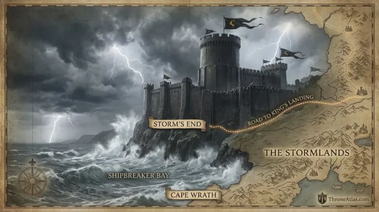
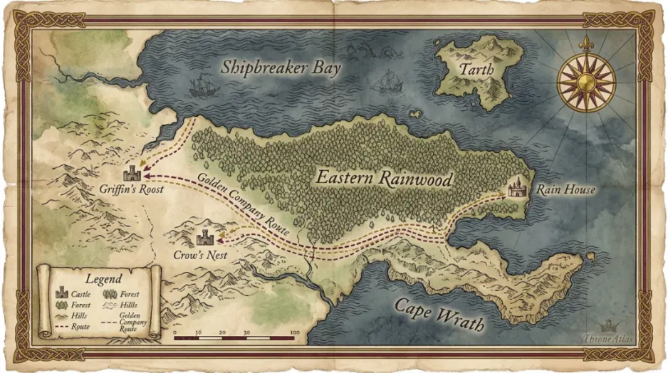
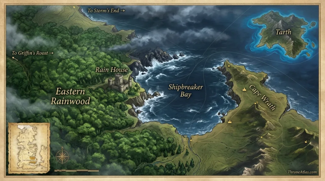
Rain House is the seat of House Wylde in the stormlands. It stands in the eastern rainwood along the southern shore of Shipbreaker Bay, near the northeastern tip of Cape Wrath. That position gives it a clear geographic identity: dense rainwood inland, dangerous bay waters to the north, Tarth offshore, and a chain of Cape Wrath strongholds connecting toward Griffin’s Roost and Crow’s Nest. During the Golden Company’s invasion in A Dance with Dragons, Laswell Peake marches on Rain House while other commanders target nearby castles. Rain House falls quickly, helping the invaders secure much of Cape Wrath.
Key Takeaways
Rain House
This is a castle-and-region atlas. The seat is mapped together with forest, coast, neighboring strongholds and invasion routes that explain its strategic value.
Eastern rainwood, Shipbreaker Bay south shore and Cape Wrath northeastern tip
Confirmed anchors and reconstructed corridors are separated.
Golden Company capture
Maintained for 2026.
Visual Atlas
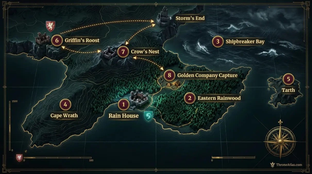
Each marker explains the geographic evidence behind the map.
Mapped Locations and Confidence
| Location / Phase | Confidence | Why it belongs on the map |
|---|---|---|
| 1. Rain House | High | The castle itself is the central anchor and ancestral seat of House Wylde. |
| 2. Eastern rainwood | High | Rain House stands within the eastern side of the rainwood, making dense forest its principal inland landscape. |
| 3. Shipbreaker Bay south shore | High | The castle lies along the southern shore of the stormlands’ most famous bay. |
| 4. Cape Wrath northeastern tip | High | Rain House sits near the northeastern edge of Cape Wrath, which fixes its place within the wider stormlands. |
| 5. Tarth offshore | High | The island of Tarth lies across nearby waters and provides a strong maritime orientation point. |
| 6. Griffin’s Roost corridor | High | Another major Cape Wrath castle becomes one of the Golden Company’s coordinated invasion targets. |
| 7. Crow’s Nest corridor | High | Crow’s Nest is attacked as part of the same campaign to control Cape Wrath. |
| 8. Golden Company capture | High | Laswell Peake’s force takes Rain House quickly, turning a local castle into one piece of a regional invasion network. |
1. Rain House
The castle itself is the central anchor and ancestral seat of House Wylde. This marker belongs on the page because it fixes a major phase of the subject to a real geographic relationship. Read it with the adjacent points to understand sequence, terrain and political meaning together.
2. Eastern rainwood
Rain House stands within the eastern side of the rainwood, making dense forest its principal inland landscape. This marker belongs on the page because it fixes a major phase of the subject to a real geographic relationship. Read it with the adjacent points to understand sequence, terrain and political meaning together.
3. Shipbreaker Bay south shore
The castle lies along the southern shore of the stormlands’ most famous bay. This marker belongs on the page because it fixes a major phase of the subject to a real geographic relationship. Read it with the adjacent points to understand sequence, terrain and political meaning together.
4. Cape Wrath northeastern tip
Rain House sits near the northeastern edge of Cape Wrath, which fixes its place within the wider stormlands. This marker belongs on the page because it fixes a major phase of the subject to a real geographic relationship. Read it with the adjacent points to understand sequence, terrain and political meaning together.
5. Tarth offshore
The island of Tarth lies across nearby waters and provides a strong maritime orientation point. This marker belongs on the page because it fixes a major phase of the subject to a real geographic relationship. Read it with the adjacent points to understand sequence, terrain and political meaning together.
6. Griffin’s Roost corridor
Another major Cape Wrath castle becomes one of the Golden Company’s coordinated invasion targets. This marker belongs on the page because it fixes a major phase of the subject to a real geographic relationship. Read it with the adjacent points to understand sequence, terrain and political meaning together.
7. Crow’s Nest corridor
Crow’s Nest is attacked as part of the same campaign to control Cape Wrath. This marker belongs on the page because it fixes a major phase of the subject to a real geographic relationship. Read it with the adjacent points to understand sequence, terrain and political meaning together.
8. Golden Company capture
Laswell Peake’s force takes Rain House quickly, turning a local castle into one piece of a regional invasion network. This marker belongs on the page because it fixes a major phase of the subject to a real geographic relationship. Read it with the adjacent points to understand sequence, terrain and political meaning together.
Rain House sits where forest meets storm sea
The castle’s strongest feature is not an elaborate internal plan but its environmental position. Rainwood behind and Shipbreaker Bay ahead create two very different movement problems.
Cape Wrath gives the castle regional importance
Rain House belongs to a chain of stormlands seats spread across Cape Wrath. That makes it useful in any campaign trying to establish control over the peninsula.
Tarth helps orient the eastern coast
The Sapphire Isle is not Wylde territory, but its offshore position makes the Rain House coast easier to understand on a regional map.
The Golden Company attacks a network, not one castle
Laswell Peake moves on Rain House while other commanders target Griffin’s Roost and Crow’s Nest. The coordinated strikes show that Cape Wrath is being treated as a geographic system.
A quick fall does not make the location unimportant
Rain House falls rapidly, yet Harry Strickland believes success at these castles will give the Golden Company control of most of Cape Wrath. Strategic value and defensive strength are not the same.
Why Rain House deserves its own map after the House Wylde page
The House Wylde map explains feudal context. This page works at castle-and-region scale, giving more attention to rainwood, shoreline, neighboring invasion targets and the Cape Wrath campaign.
Rain House belongs to a Cape Wrath network
The castle is one of several strongholds whose value emerges when seen together. Griffin’s Roost, Crow’s Nest, Storm’s End and the coastline form a regional system rather than isolated dots.
Forest and sea create different access problems
An army approaching through the rainwood faces dense terrain; a fleet approaching Shipbreaker Bay faces dangerous water and weather. The castle’s location sits between both environments.
Strategic value is not measured by siege length
Rain House falls quickly to the Golden Company, but the invaders still consider the castle important to controlling Cape Wrath. Geography can make a modest fortress valuable even when its garrison cannot resist indefinitely.
Local map versus house map
House Wylde’s page explains the family’s political geography. This page zooms in on the seat itself and the surrounding Cape Wrath terrain. The two scales complement rather than duplicate each other.
How to read the Rain House Map
Begin with Rain House, then locate Cape Wrath northeastern tip, and finally follow the page toward Golden Company capture. Those three anchors establish the center, a major transition and the outer consequence of the map. They are not necessarily three consecutive stops; on a battle or house page they may represent strategic phases rather than a literal journey.
This is a castle-and-region atlas. The seat is mapped together with forest, coast, neighboring strongholds and invasion routes that explain its strategic value.
The atlas keeps physical geography separate from temporary political control. A castle can change hands without moving. A dragon can change rider or faction while keeping the same lair. A house can lose lands while its ancestral seat remains fixed. That separation lets the page remain useful across different periods.
Distance, movement and practical geography
Fantasy maps invite straight-line assumptions, but real movement inside the story follows practical constraints. Armies need roads, food and safe crossings. Ships need navigable water and workable weather. Dragons can ignore many ground barriers, yet their riders still act from castles, ports and allied positions. Noble houses depend on the river and road systems around their seats.
For that reason, ThroneAtlas does not turn every pair of known points into a rigid route. If the source describes only origin and destination, the map shows a corridor. If a lair or battlefield is explicitly placed, that point receives stronger confidence. The visual result is intentionally evidence-led rather than decorative.
What changes when you zoom out
At local scale, Rain House may dominate the page. Zoom out and it becomes one node inside a larger system. Cape Wrath northeastern tip may connect the subject to another kingdom, a battlefront, a maritime chokepoint or a royal capital. Golden Company capture then shows where that story ends or where its consequences spread.
This is why related maps matter. The same location can play different roles on a regional map, a battle map and a character or dragon route. The geography stays stable while the question changes.
Confirmed geography versus reconstruction
High-confidence markers come from direct place names, published maps or unambiguous narrative positioning. Medium-confidence markers represent broad zones or relationships that are strong but not precise enough for a survey point. Low confidence is reserved for locations or route segments whose exact placement remains unresolved.
Confidence is not the same as importance. A legendary or disputed event can be central to the lore while still being poorly mapped. A small river junction may be geographically exact while receiving only a few lines in the story.
Fast atlas answers
Primary anchor
Rain House is the first place to locate for orientation.
Key transition
Cape Wrath northeastern tip changes the map’s strategic or chronological meaning.
Final connection
Golden Company capture gives the clearest endpoint or wider consequence.
Why the geography changes the story
Rain House is the seat of House Wylde in the stormlands. It stands in the eastern rainwood along the southern shore of Shipbreaker Bay, near the northeastern tip of Cape Wrath. That position gives it a clear geographic identity: dense rainwood inland, dangerous bay waters to the north, Tarth offshore, and a chain of Cape Wrath strongholds connecting toward Griffin’s Roost and Crow’s Nest. During the Golden Company’s invasion in A Dance with Dragons, Laswell Peake marches on Rain House while other commanders target nearby castles. Rain House falls quickly, helping the invaders secure much of Cape Wrath.
Seen as text alone, these events can feel like a sequence of names. On a map, causes become easier to see. Distance explains why relief arrives late. A bay explains why fleets and dragons operate together. A river confluence explains why a house seat is prosperous. A mountain, forest or castle network explains why an invading army chooses several targets at once.
This spatial reading does not replace the narrative. It tests and organizes it. A good atlas lets readers move back to the story with a clearer sense of what was physically possible, which locations were close, and why commanders or riders made particular choices.
Time, control and changing meaning
Many locations on this page change meaning over time. A dragon lair can become a military base. A town can become a battlefield. A castle can shift from family home to invasion target. A route can carry merchants in peace and armies in war. The page describes those phases rather than freezing one moment as permanent geography.
Chronology is therefore embedded in the numbered sequence and the written sections. The visual atlas should be read as a layered overview, not as proof that every marker represents the same day or political situation.
Cartographer’s field notes
The strongest atlas pages are comfortable leaving some space unresolved. Not every stretch of road has a name. Not every dragon flight has a recorded path. Not every noble estate has surveyed borders. Filling those gaps would make the graphic look complete while making the information less reliable.
The three image positions are designed for different jobs. The hero establishes atmosphere and region. The primary atlas image should carry the finished geographic visual with labels and terrain. The contextual image can focus on the most important secondary relationship—battlefield, lair, river system, neighboring castle or route. Their alt text describes those roles rather than simply repeating the headline.
If future published material clarifies an uncertain point, the page can be updated without changing the overall structure. That is one advantage of separating confidence from importance: new evidence can move a marker without forcing the whole interpretation to be rewritten.
How this page fits the full ThroneAtlas
The related links below are chosen to change scale or perspective. Regional pages explain the wider landscape. Battle pages show temporary control. House pages explain allegiance. Dragon and character routes add chronology. Using several together gives a clearer picture than forcing every layer into one overcrowded map.
Rain House Map therefore stays focused on one geographic question while still functioning as part of the larger ThroneAtlas network.
What to compare next
Use the related maps below to change scale. A regional map shows the larger terrain; a battle or city map provides close detail; a house or character page explains political or personal movement. The strongest atlas reading comes from comparing the same anchor across several layers.
This page stays focused on its own geographic question so those connections remain clean and useful rather than repetitive.
Map Accuracy and Canon Confidence
High confidence marks geography directly established in the published material. Medium confidence marks a strong regional reconstruction or grouped phase. Low confidence is reserved for unresolved coordinates or disputed placement.
ThroneAtlas does not add exact borders, flight paths, battle lines or minor roads simply to make the graphic look complete. Where the record becomes uncertain, the atlas keeps that uncertainty visible.
Source Basis
This atlas follows the location of Rain House in The Lands of Ice and Fire and A Feast for Crows, with its later Golden Company role from A Dance with Dragons. The castle’s regional placement is strong; individual internal roads and building plans remain undescribed.
The page is an interpretive atlas built from established place relationships and chronology. It is designed to answer where events happen, how locations connect and how confidently each part can be mapped.
Frequently Asked Questions
Where does the Rain House map begin?
The first major anchor is Rain House. From there the atlas follows the strongest chronological or regional sequence.
What is the most important location on this Rain House map?
Cape Wrath northeastern tip is a major turning point, while Golden Company capture marks the final or widest consequence of the map.
Is this Rain House map based on published canon?
Yes. The base geography follows the published novels, Fire & Blood and official world maps. Uncertain details are labeled rather than presented as equally firm.
Are all map lines exact?
No. Confirmed locations are distinguished from reconstructed corridors. The atlas does not invent a precise flight, march or road where the source only provides destinations.
What does High confidence mean?
High means a place or relationship is directly established by the source geography. Medium marks a strong regional reconstruction. Low is used for genuinely unresolved points.
Why are nearby places included?
Nearby locations explain scale, strategy and movement. Their appearance on the map does not imply ownership or a confirmed visit unless the text says so.
Can I use this map for exact mileage?
No. The visual atlas is designed for relative position, route logic and strategic context rather than modern GPS measurement.
How does ThroneAtlas handle conflicting accounts?
The page preserves the shared geographic facts and identifies where chroniclers disagree instead of choosing one uncertain version without warning.
What should I open next?
The Continue Exploring section links to the strongest regional, battle, house, dragon and location pages connected to the same geography.
When was this Rain House map updated?
This ThroneAtlas page is maintained as a 2026 edition and intentionally avoids a fixed day-and-month freshness stamp.