Tarth Map
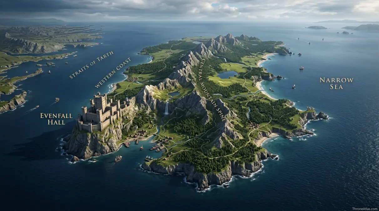
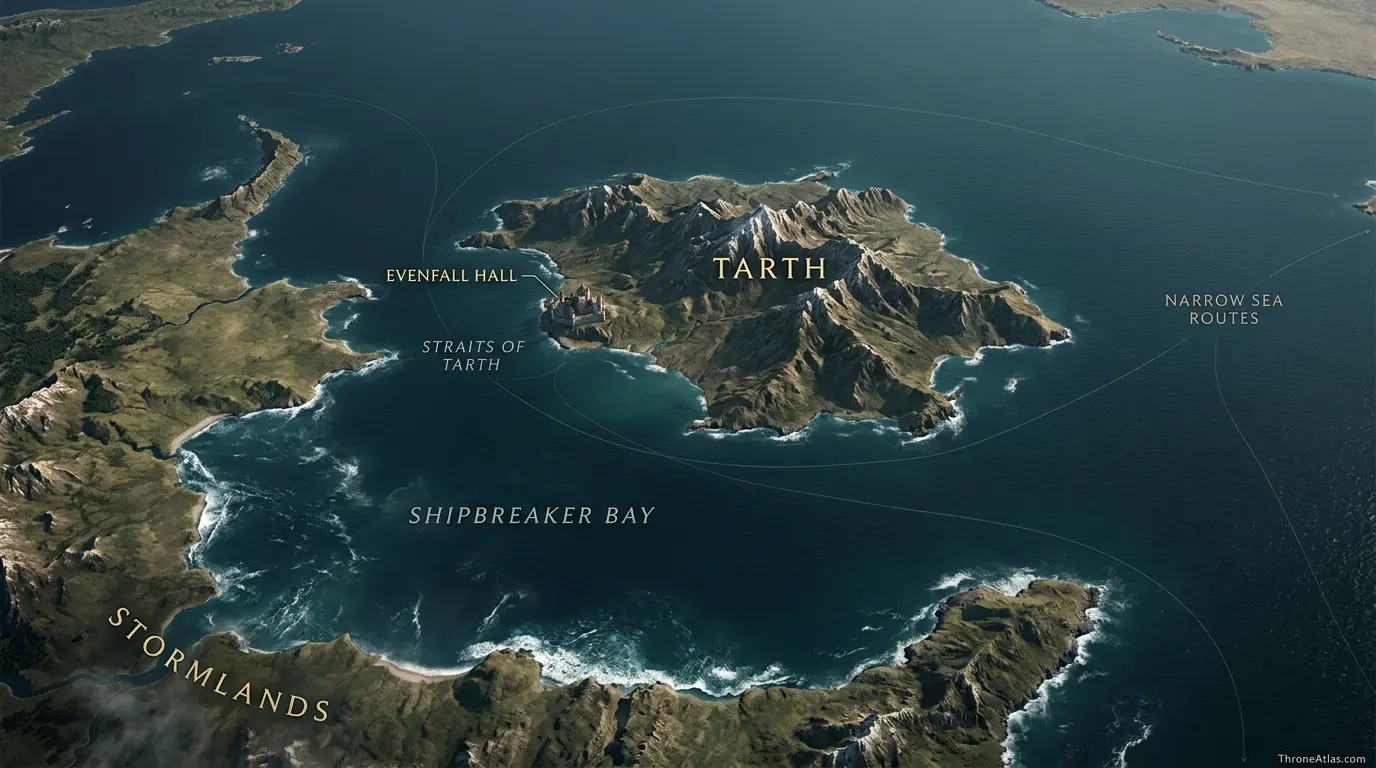
Tarth, the Sapphire Isle, lies in the narrow sea off the eastern coast of the stormlands, separated from the mainland by the Straits of Tarth and positioned northeast of Shipbreaker Bay. A mountainous spine runs down the island with hidden valleys, lakes, waterfalls, high meadows and wooded vales. Evenfall Hall, seat of House Tarth, stands on the western coast. The island’s location makes it both beautiful and strategic: it watches the sea lanes east of the stormlands while remaining closely tied to Storm’s End.
Key Takeaways
Evenfall Hall
This is an island geography atlas. Coastlines, straits, mountains and sea approaches are as important as the principal castle.
Western coast, Straits of Tarth and Central mountain spine
Confirmed anchors are separated from reconstructed corridors.
Narrow Sea routes
Maintained for 2026.
Visual Atlas
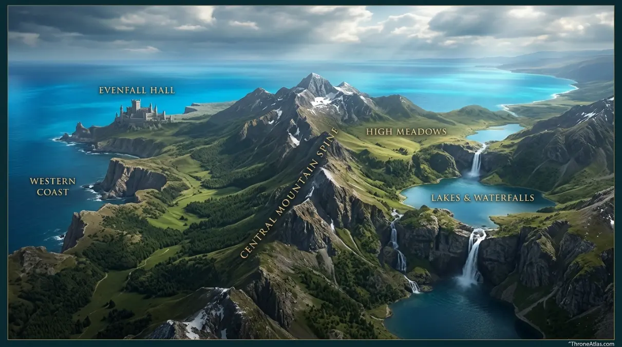
Each marker opens a short explanation of why that place belongs on this map.
Mapped Locations and Confidence
| Location / Zone | Confidence | Why it belongs on the map |
|---|---|---|
| 1. Evenfall Hall | High | The seat of House Tarth stands on the western coast and is the island’s clearest political and settlement anchor. |
| 2. Western coast | High | The western shore faces the Straits of Tarth and mainland stormlands, making it the natural side for communication with Storm’s End and nearby coasts. |
| 3. Straits of Tarth | High | The straits separate the island from the mainland and define Tarth as a distinct maritime territory. |
| 4. Central mountain spine | High | A chain of mountains runs down the island, creating hidden valleys and shaping movement between coasts. |
| 5. High meadows and vales | High | The island is noted for high meadows, shadowed vales and scenic uplands, which belong to its well-established interior character. |
| 6. Lakes and waterfalls | Medium | Tarth contains lakes and waterfalls, but the source material does not map each feature individually, so they are shown as an interior landscape zone. |
| 7. Shipbreaker Bay | High | The bay lies southwest of Tarth and is the most important large-scale orientation point for the island relative to Storm’s End. |
| 8. Narrow Sea routes | High | Tarth’s eastern side opens toward the narrow sea, placing the island on routes between the stormlands, Stepstones approaches and ports across the water. |
1. Evenfall Hall
The seat of House Tarth stands on the western coast and is the island’s clearest political and settlement anchor. On an island map, this anchor helps connect interior terrain to the surrounding sea. It explains either how people move across Tarth or how ships approach and leave it.
2. Western coast
The western shore faces the Straits of Tarth and mainland stormlands, making it the natural side for communication with Storm’s End and nearby coasts. On an island map, this anchor helps connect interior terrain to the surrounding sea. It explains either how people move across Tarth or how ships approach and leave it.
3. Straits of Tarth
The straits separate the island from the mainland and define Tarth as a distinct maritime territory. On an island map, this anchor helps connect interior terrain to the surrounding sea. It explains either how people move across Tarth or how ships approach and leave it.
4. Central mountain spine
A chain of mountains runs down the island, creating hidden valleys and shaping movement between coasts. On an island map, this anchor helps connect interior terrain to the surrounding sea. It explains either how people move across Tarth or how ships approach and leave it.
5. High meadows and vales
The island is noted for high meadows, shadowed vales and scenic uplands, which belong to its well-established interior character. On an island map, this anchor helps connect interior terrain to the surrounding sea. It explains either how people move across Tarth or how ships approach and leave it.
6. Lakes and waterfalls
Tarth contains lakes and waterfalls, but the source material does not map each feature individually, so they are shown as an interior landscape zone. On an island map, this anchor helps connect interior terrain to the surrounding sea. It explains either how people move across Tarth or how ships approach and leave it.
7. Shipbreaker Bay
The bay lies southwest of Tarth and is the most important large-scale orientation point for the island relative to Storm’s End. On an island map, this anchor helps connect interior terrain to the surrounding sea. It explains either how people move across Tarth or how ships approach and leave it.
8. Narrow Sea routes
Tarth’s eastern side opens toward the narrow sea, placing the island on routes between the stormlands, Stepstones approaches and ports across the water. On an island map, this anchor helps connect interior terrain to the surrounding sea. It explains either how people move across Tarth or how ships approach and leave it.
Why Tarth is called the Sapphire Isle
The name reflects the striking blue waters around the island, but the map shows that the identity goes deeper than color. Tarth combines mountains, valleys, lakes, waterfalls and meadows within a compact island space. The contrast between rugged interior and bright surrounding sea is central to how the place is imagined.
Evenfall Hall faces the mainland side
Placing Evenfall Hall on the western coast is geographically sensible because that side faces the Straits of Tarth and the stormlands mainland. The castle’s position ties House Tarth to Storm’s End while keeping the island protected by water.
Mountains divide the interior
The central mountain spine means crossing Tarth is not simply a matter of walking east to west. Hidden valleys and high ground shape local movement and make the island more complex than its outline suggests. A map that shows only the coastline misses this interior structure.
Tarth in stormlands strategy
The island sits northeast of Shipbreaker Bay and east of the stormlands coast. That makes it relevant to sea movement around Storm’s End and the narrow sea even when it is not the center of a campaign. Its strategic value comes from position, defensible water and control of a substantial island close to the mainland.
An island has two maps at once
Tarth must be read internally and externally. Internally, mountains, valleys and the location of Evenfall Hall shape movement across the island. Externally, straits, bays and narrow-sea routes determine how the island connects to the stormlands and the wider world.
Coastline creates defense and dependence
Water makes invasion harder, but it also makes ships essential. Food, messages, soldiers and trade depend on safe landings and favorable sea conditions. That tension between protection and connection is at the heart of island strategy.
Landscape description versus exact placement
The books give vivid descriptions of Tarth’s beauty but do not place every waterfall, lake and valley on a measured plan. The atlas treats those features as confirmed parts of the interior landscape without inventing coordinates for each one.
Reading Tarth Map as a connected atlas
The most useful way to read this map is to move from Evenfall Hall toward Central mountain spine and then outward to Narrow Sea routes. That sequence does not necessarily describe a literal journey. Instead, it provides a hierarchy of geography: the central anchor, the feature that explains the local setting, and the wider connection that places the subject inside Westeros.
That hierarchy matters because map searches often hide several questions inside one phrase. A reader may want to know where a place is, how a character reached it, what lies nearby, why it was strategically valuable, or whether a television depiction matches book geography. A strong atlas page should let the same map answer all of those questions without blurring confirmed facts and reconstruction.
This is an island geography atlas. Coastlines, straits, mountains and sea approaches are as important as the principal castle.
Distance, movement and practical travel
Fantasy maps are easiest to misuse when straight-line distance is treated as the only measure of movement. Roads bend toward gates and bridges. Ships need safe approaches and workable weather. Armies need food, ground and defensible camps. Even short urban journeys may climb steep hills or funnel through crowded markets. The route a traveler can actually use is therefore shaped by terrain and infrastructure.
This page uses known roads, coastlines, waterways and urban anchors to suggest practical movement without assigning unsupported travel times. When the sources give a clear road or route, it is named. When they give only relative direction, the map keeps the relationship broad. That difference is part of the atlas rather than hidden from the reader.
Political geography around Evenfall Hall
Physical geography does not change as quickly as political control. A road may remain the same while a different king holds the capital; a harbor may serve merchants in one year and raiders in another; a marcher castle may answer to a different claimant without moving an inch. For that reason, the map separates permanent features from temporary control whenever possible.
The result is especially useful for comparing eras. Readers can open related battle, journey and house maps and recognize the same roads, bays, gates and strongholds under different political conditions. That consistency is one of the main advantages of a connected atlas rather than a collection of isolated articles.
What changes when you zoom out
At close scale, Evenfall Hall dominates the page. Zoom out and the meaning changes. The local feature becomes part of a larger corridor: a city gate becomes a road entrance, a harbor becomes a narrow-sea port, a marcher seat becomes a frontier stronghold, and an island becomes part of a coastal defense system. The wider view explains why seemingly modest places repeatedly appear in major events.
Zooming out also prevents exaggerated importance. Not every named landmark controls an entire region. The atlas shows connection without claiming domination. That is particularly important for small houses and market towns, where local importance can be high even though political reach remains limited.
Fast map answers
Best starting point
Evenfall Hall gives the clearest first orientation and should be located before reading the secondary markers.
Key geographic shift
Central mountain spine changes how the map is understood by introducing elevation, defense, coastline, road structure or frontier terrain.
Wider connection
Narrow Sea routes links the local map to a larger region or route and is the best point for continuing into related ThroneAtlas pages.
Cartographer’s field notes
Three layers are kept separate throughout this atlas. The first is confirmed geography: places and relationships explicitly established in the published material. The second is regional reconstruction: a route or zone that can be placed confidently in a broad area even though every turn is not described. The third is unknown detail, which is left unresolved instead of being filled for visual convenience.
This method can make a map appear slightly less absolute than many fan-made graphics, but it is more useful for serious readers. If a point is marked High confidence, you can treat the placement or relationship as firmly grounded. Medium confidence means the relationship is strong but not survey-level. Where neither standard can be met, the page says so.
The visual image and interactive schematic serve different purposes. The finished image gives the page an at-a-glance atlas experience and can carry richer terrain artwork. The schematic underneath keeps the map accessible and interactive, with text explanations attached to each numbered marker. Together they support both visual browsing and detailed reading.
Why Tarth Map matters in the wider story
Tarth, the Sapphire Isle, lies in the narrow sea off the eastern coast of the stormlands, separated from the mainland by the Straits of Tarth and positioned northeast of Shipbreaker Bay. A mountainous spine runs down the island with hidden valleys, lakes, waterfalls, high meadows and wooded vales. Evenfall Hall, seat of House Tarth, stands on the western coast. The island’s location makes it both beautiful and strategic: it watches the sea lanes east of the stormlands while remaining closely tied to Storm’s End.
The map gains additional value when the surrounding region is visible. A location can be narratively memorable for one scene while geographically important for entirely different reasons. Trade routes, military approaches, food supply, defensive terrain and political allegiance often outlast the event that first made a place famous to readers. By mapping both the memorable scene and the durable geography, ThroneAtlas gives the location a longer useful life than a plot summary alone.
This is also why nearby locations are linked rather than merely mentioned. Moving from this page to the regional map lets readers test scale; moving to a battle or journey page adds chronology; moving to a house page adds political control. The same geographic anchor can therefore support several kinds of questions without forcing all of them into one oversized map.
Book map versus imagined city plan
Published maps provide relative position, named landmarks and broad routes, but they are not engineering plans. A street may curve without every bend being measured. A coastline may be recognizable without exact nautical coordinates. A castle’s region may be firm while the edge of its lord’s lands remains undefined. This page preserves that distinction throughout.
For readers comparing the novels with screen adaptations, the underlying relationship between major places is more important than the exact appearance of a set or filming location. ThroneAtlas therefore treats screen visuals as interpretation and the published world geography as the structural base. That keeps the atlas useful across adaptations and future retellings.
How to use this page with the wider ThroneAtlas
Start with the Quick Answer if you need orientation in seconds. Use the visual atlas for spatial relationships, then scan the confidence table to see which details are firm and which are reconstructed. The long-form sections explain why those points matter. Finally, use the related maps to move outward into the larger region, conflict or character route.
This layered structure is intentional. A casual reader should be able to leave with a clear answer after a minute, while a lore-focused reader can continue into the deeper geography without encountering filler. The result is an atlas page first and an article second.
Map Accuracy and Canon Confidence
High confidence is used for directly named and geographically established places, roads, gates, rivers, coastlines or castle relationships. Medium confidence marks a strong regional reconstruction where the source gives direction or context without every intermediate step. Low confidence is reserved for genuinely uncertain geography.
ThroneAtlas does not add precise streets, borders or routes simply to make a graphic look complete. Where the canon stops, the certainty stops too.
Source Basis
This atlas follows the geography described in A Storm of Swords, A Feast for Crows, A Dance with Dragons and The World of Ice & Fire. Tarth’s island position, central mountains and western-coast seat are strong; the placement of unnamed valleys and lakes remains generalized.
The page is designed as an interpretive atlas: it organizes named geography into a form that answers where the subject sits, what lies around it, which roads or waterways connect to it, and why the location matters. It does not reproduce the source books or substitute conjecture for missing cartographic detail.
Frequently Asked Questions
Where is Tarth located?
Tarth is mapped using Evenfall Hall, Western coast and Straits of Tarth as the first major orientation anchors. The page emphasizes relative position and known routes rather than invented modern coordinates.
What is the main landmark on the Tarth map?
Evenfall Hall is the primary anchor, while Central mountain spine and High meadows and vales provide the strongest surrounding context.
Is this Tarth map based on book canon?
Yes. The layout follows published maps and narrative descriptions from the main novels and world-history material, with uncertainty called out where exact placement is not provided.
Are all marker positions exact?
No. High-confidence markers represent directly established places or relationships. Medium-confidence markers show strong regional placement or movement without claiming survey-level precision.
Why does the map include nearby roads, bays or castles?
Because those features explain how the location functions. A place becomes more useful on an atlas when readers can see what connects to it, not only where the central pin sits.
Does the interactive atlas replace the image map?
No. The image slot is intended for the finished visual map, while the interactive schematic provides a fast, accessible way to explore the same key anchors and explanations.
Can this map be used to measure exact mileage?
No. It is designed for orientation, sequence and strategic relationships. Published fantasy maps do not support modern GPS-level measurements.
What does the confidence label mean?
High means directly supported by mapped or textual geography. Medium means a strong reconstruction at regional scale. Low is used only where the source material itself remains genuinely uncertain.
What other ThroneAtlas pages connect to Tarth?
The Continue Exploring section links to the closest geographic and story-related maps so readers can move from this local view into the wider region.
When was this Tarth map updated?
This page is maintained as a 2026 edition. ThroneAtlas uses the year rather than a fixed day-and-month stamp for evergreen atlas pages.