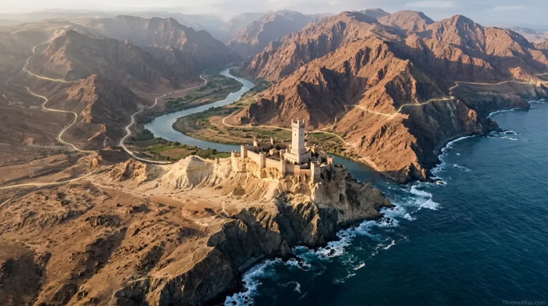
House Dayne MapStarfall, Dawn, the Torrentine and Tower of Joy Links
Western Dorne · Noble House Territory · House Dayne
The House Dayne map centers on Starfall in western Dorne and connects the house to Dawn, the Sword of the Morning, the Torrentine, and the Tower of Joy. House Dayne matters because it sits at the meeting point of Dornish geography, legendary knighthood, and one of the most important mysteries in the Stark-Targaryen story.
The House Dayne map centers on Starfall in western Dorne and connects the house to Dawn, the Sword of the Morning, the Torrentine, and the Tower of Joy. House Dayne matters because it sits at the meeting point of Dornish geography, legendary knighthood, and one of the most important mysteries in the Stark-Targaryen story.
What the House Dayne map Shows
The House Dayne map is a focused atlas view of a western Dornish house whose geography meets legend. Instead of treating the name as a loose reference, this page reads it as part of a larger geographic system: roads, borders, rivers, ports, mountains, nearby seats, family loyalty, and the political pressure created by distance. In Westeros and Essos, location is never neutral. A castle on a road is a gate. A city on a bay is a trade weapon. A sacred center on open grassland can rule without walls. A northern hold near the Wall feels the world differently from a southern court beside warm water.
For readers, the value of this page is not only knowing where House Dayne sits. The deeper value is understanding why its position changes the behavior of characters and houses around it. House Dayne is not powerful because it rules Dorne. It is powerful because its seat, sword, bloodline, and knightly reputation carry rare symbolic weight across the continent. If the page is read together with the related maps, the location becomes easier to place in the larger story: who can reach it, who can defend it, who has reason to fear it, and which routes make it important.
The map should be read with three layers in mind. The first layer is physical geography: the terrain, nearby waters, mountains, roads, and neighboring settlements. The second layer is political geography: House Dayne, rival powers, ruling houses, bannermen, and the tension between local authority and royal command. The third layer is story geography: the journeys, wars, betrayals, marriages, exiles, campaigns, and memories that make the place matter to the audience.
Geographic Position and Nearby Landmarks
House Dayne belongs to Western Dorne, with important nearby references including Starfall, Torrentine, Tower of Joy. That surrounding geography gives the location its identity. Some places are famous because they are capitals; others are famous because they sit at a crossing, guard a pass, overlook a coast, control a family territory, or create a bottleneck between larger powers. This page focuses on those quiet map details because they often explain major decisions long before swords are drawn.
When placing this location on a ThroneAtlas map, avoid drawing it in isolation. Its meaning comes from how it sits between stronger map anchors. One anchor is political: which house claims it or influences it. Another anchor is movement: who must pass near it to travel between regions. A third anchor is memory: which events or character arcs become clearer once the place is fixed in relation to the rest of the Known World.
The surrounding region also affects how the location should look visually. A northern frontier hold should feel exposed, cold, and distant. A Dornish mountain road should feel narrow, hot, and difficult. A Reach house seat should feel fertile but militarily connected. An Essosi city should feel tied to trade, pilgrimage, slavery, horse culture, or imperial ruins. The purpose of the map is to show those differences without forcing every page into the same flat geography.

Strategic Importance
Starfall’s coastal position gives House Dayne a different map identity from the desert and mountain houses of Dorne. It is remote, prestigious, and closely tied to river and sea movement.
Strategic importance in this world usually comes from one of five conditions: control of a road, command of a coastline, access to a river, ownership of fertile land, or proximity to a threat. House Dayne fits into that logic through its connection to Western Dorne and its relationship with House Dayne. Even when a location does not appear in every episode, its map position can explain why certain families remain influential for generations.
Distance is also part of strategy. The farther a location sits from the royal center, the more local custom matters. Northern houses, Dornish marcher seats, and Essosi cities do not behave like courtiers living beside the Red Keep. They answer to weather, roads, old bloodlines, sworn loyalties, religious customs, trade pressures, and military geography. That is why a proper atlas page must explain the setting as much as the headline event.
| Map Layer | What It Shows | Why It Matters |
|---|---|---|
| Region | Western Dorne | Defines climate, culture, travel difficulty and neighboring powers. |
| Primary Power | House Dayne | Shows the house, rulers or faction most closely tied to the map point. |
| Nearby Places | Starfall, Torrentine, Tower of Joy | Builds a practical route network for readers following the story. |
| Story Era | Ancient Dorne, Robert’s Rebellion and Stark-Targaryen lore | Connects the page to the wars, reigns and journeys where it becomes useful. |
Routes, Roads and Movement Logic
The route logic around House Dayne is one of the most useful parts of the page. Maps in this universe are not only decorative; they tell the reader why a commander chooses one road, why a fugitive avoids another, why a marriage alliance matters, or why a remote castle can still influence a war. The location should be traced outward: first to the closest landmarks, then to the nearest regional capital, and finally to the larger political theater.
Movement is especially important because the story often depends on timing. A raven can travel faster than an army. A mounted party can move where a supply train cannot. A fleet can bypass land defenses but becomes vulnerable to storms, reefs, narrow bays or enemy ships. A mountain pass may look short on a simplified map yet become deadly when heat, elevation, ambush and food are considered. The House Dayne map should therefore be interpreted as a practical travel problem as much as a location entry.
For route reading, begin with Starfall Map, then compare the path toward Tower of Joy Map and Dorne Map. Those pages help show whether this location is part of a defensive chain, a trade road, a frontier line, a noble house network, or a campaign route.
Route Anchor
Starfall, Torrentine, Tower of Joy gives readers the closest practical references for placing the map point.
Power Anchor
House Dayne explains who benefits from the location and who may challenge it.
Story Anchor
Ancient Dorne, Robert’s Rebellion and Stark-Targaryen lore gives the page its clearest timeline connection.
History and Lore Context
The lore surrounding House Dayne becomes stronger when the page is read as part of a timeline. Places carry memory. A castle remembers the families that ruled it. A pass remembers the armies that tried to cross it. A city remembers the people bought, freed, crowned, exiled, judged, or betrayed within it. This is why the atlas approach is different from a simple encyclopedia entry: it asks how history is stored in geography.
In the wider timeline, House Dayne connects most naturally to Ancient Dorne, Robert’s Rebellion and Stark-Targaryen lore. That does not mean the place matters only in one period. It means that this era gives readers the strongest entry point. Once the location is fixed, earlier and later events become easier to understand. A house seat may explain a family’s loyalty. A road may explain a battle. A sacred city may explain why an outsider cannot simply command respect by force.
Political geography also changes with memory. A house that once held greater power may still act with old pride. A road that once stopped invaders may remain symbolically important centuries later. A city that once supplied armies may carry the scars of conquest long after the conquering army leaves. These lingering layers help explain why map pages can answer questions that character summaries often miss.

Houses, Characters and Political Connections
The most important connection on this page is House Dayne. A location becomes much easier to understand once the reader asks who benefits from it. A ruling family may benefit from taxes, defense, prestige, bloodline legitimacy, army routes, port access or symbolic authority. In this case, the connection to House Dayne gives the map point its political weight.
Character connections should be read carefully. Not every character physically visits every place tied to their house or campaign, yet the map still affects them. A lord’s identity is shaped by the seat he inherits. A commander’s choices are shaped by the roads available to him. A queen’s claim may depend on the ancestral island she controls. A northern child’s future may be shaped by how far her home sits from the capital. In this sense, geography becomes biography.
This is why ThroneAtlas groups locations, houses, battles, routes and lore pages together. The related links are not decoration; they are the natural reading path for a fan trying to understand the story from the ground up. After reading this page, compare it with Starfall Map, Tower of Joy Map, and Dorne Map to see the wider map logic.
- House link: House Dayne is the main political or cultural power tied to this page.
- Regional link: Western Dorne explains the climate, road network and nearby powers.
- Story link: Ancient Dorne, Robert’s Rebellion and Stark-Targaryen lore gives the page its clearest narrative setting.
- Map link: Starfall, Torrentine, Tower of Joy helps readers locate the page visually.
Book vs Show Map Reading
The show uses Arthur Dayne mainly through the Tower of Joy, while the books attach more mystery and symbolic depth to House Dayne, Dawn, and Starfall.
The difference between book and show geography matters because adaptations often compress travel, simplify borders, or reduce secondary houses to a few memorable scenes. A map page can restore some of that depth by placing each location back into a broader network. For House Dayne map, that means reading both the visible story and the implied geography behind it.
Readers who only watch the show may remember the strongest visual or dramatic moment tied to a place. Readers of the books may recognize additional houses, roads, customs, heirs, rivalries, or historical references. Both approaches are useful, but the atlas reading is strongest when it keeps them separate: what is shown directly, what is described in lore, and what can be inferred from the map.
Visual Map Guide
A strong visual for the House Dayne map should show more than a single marker. It should include Starfall, Torrentine, Tower of Joy, at least one regional boundary, the main route or terrain feature, and a clear label for House Dayne. If the page is a house map, the visual should show the seat and surrounding influence. If the page is a pass or road, the visual should show direction, obstacles and the regions being connected. If the page is a city, the visual should show coastline, roads, nearby settlements and campaign movement.
The best image layout uses a cinematic map background, muted parchment texture, gold route lines, red or blue pins for conflict or travel, and a small ThroneAtlas-style title panel. The alt text should describe the actual map subject in plain language: for example, the location name, the region, the nearest landmark and the main house or route. This helps readers and image search understand the visual without relying on decorative text inside the image.

Common Map Mistakes
The common mistake is treating House Dayne only as Arthur Dayne’s house. The map also explains Starfall, the Torrentine, and why western Dorne has a distinct identity.
Another mistake is ignoring scale. Distances in the Known World are large, roads are uneven, and political borders do not behave like modern lines on a clean map. A house may influence land beyond its walls, but that does not mean it controls every road without challenge. A route may connect two regions, but that does not make it safe. A city may be wealthy, but wealth does not automatically create stable rule.
The safest reading is to keep three questions beside the map: who controls the nearest road, who can defend the surrounding land, and who has the most to lose if the route changes hands? Those questions turn the House Dayne map from a flat location label into a useful reading tool.
| Mistake | Better Reading |
|---|---|
| Reading the place alone | Read it beside Starfall, Torrentine, Tower of Joy and the nearest regional hub. |
| Ignoring the house link | Use House Dayne to understand local power and loyalty. |
| Flattening terrain | Consider roads, elevation, coastlines, weather, rivers and border pressure. |
| Mixing book and show geography | Keep direct screen events separate from deeper lore and map inference. |
Where to Go Next
After this page, the most useful next step is to follow the surrounding atlas cluster. Begin with Starfall Map for the closest map context, then open Tower of Joy Map to compare the nearest major location or house connection. If you are following a war, route or character arc, continue into Dorne Map and the broader maps listed in the related network below.
This reading order keeps the map practical. Instead of jumping from one famous name to another, you move the way the story moves: across roads, through passes, along coasts, between castles, toward capitals, away from danger, and into the places where power becomes visible.
Follow the Surrounding Maps
Use these related maps to follow nearby places, connected houses, character routes, battles and lore events across ThroneAtlas.
Nearby Maps
Story Routes
Atlas Hubs
House Dayne Map FAQ
Clear answers to the most common reader questions about this map, its region and its story connections.
Where is House Dayne on the map?
House Dayne belongs to Western Dorne and is best understood through nearby places such as Starfall, Torrentine, Tower of Joy. Its map position matters because Starfall’s coastal position gives House Dayne a different map identity from the desert and mountain houses of Dorne. It is remote, prestigious, and closely tied to river and sea movement.
Why is the House Dayne map important?
The House Dayne map is important because it explains a western Dornish house whose geography meets legend. It adds context to nearby houses, roads, battles, journeys and political decisions across the wider ThroneAtlas network.
Which house is connected to House Dayne?
The main connected power is House Dayne. The page also links the location to surrounding rulers, military routes and regional alliances where relevant.
Is House Dayne more important in the books or the show?
The show uses Arthur Dayne mainly through the Tower of Joy, while the books attach more mystery and symbolic depth to House Dayne, Dawn, and Starfall.
What is the most common map mistake about House Dayne?
The common mistake is treating House Dayne only as Arthur Dayne’s house. The map also explains Starfall, the Torrentine, and why western Dorne has a distinct identity.
What should I read next after this page?
Start with the related atlas links on this page, especially Starfall Map, Tower of Joy Map, and Dorne Map. Those pages show the surrounding geography and story context.
Explore the Full Westeros Map
Place this page beside the larger continent map to compare regions, castles, houses, routes and wars across the Known World.