

Winterfell to King’s Landing Distance, Travel Time and the Kingsroad Route
Straight line · Kingsroad · Horse · Army · Dragon
Winterfell and King’s Landing sit at opposite ends of the Kingsroad. Here is how far apart they are, how long the trip takes and every major stop on the way.
Winterfell is about 1,350 miles from King’s Landing in a straight line and roughly 1,560 miles by the Kingsroad. A lone rider needs about 39 days, a marching army about 104 days and a dragon about 23 hours of flight. Riding to White Harbor and sailing south cuts the trip to about 23 days.
Distance & Travel Time
The essentials at a glance before the full breakdown.
How far is Winterfell from King’s Landing?
On the ThroneAtlas grid, Winterfell lies about 1,356 miles north of King’s Landing. The Kingsroad is not straight, so the riding distance is closer to 1,560 miles.
That makes it one of the longest journeys in the story, roughly the distance from New York to Denver.
| Method | Distance | Time |
|---|---|---|
| Lone rider | ≈ 1,560 mi | ≈ 39 days |
| Marching army | ≈ 1,560 mi | ≈ 104 days |
| Road to White Harbor + ship | ≈ 380 mi + 1,340 mi | ≈ 23 days |
| Dragon | ≈ 1,356 mi | ≈ 23 flying hours |
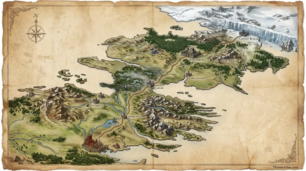
The route, stop by stop
From Winterfell the Kingsroad runs south through the empty heart of the North to Moat Cailin, the ruined fortress that guards the causeway through the Neck. Beyond the swamps it passes the Twins to the west, reaches the Crossroads Inn and crosses the Trident near the Ruby Ford, where Robert killed Rhaegar at the Battle of the Trident.
The last stretch runs through the Crownlands to the King’s Gate of the capital. See the King’s Landing gates map for how travellers enter the city.
Who made this journey
Eddard Stark rode south with King Robert’s court to become Hand of the King, and near the Trident Lady was killed after the clash over Nymeria. Arya later fled north along the same road with Yoren’s recruits, and Robb Stark’s host marched south through Moat Cailin. Follow them on the Ned Stark, Arya Stark and Robb Stark maps.

How ThroneAtlas calculates distances
Every location on ThroneAtlas sits on one grid scaled to the 300-mile Wall, the only firm measurement in the books. Road distance adds 15% to the straight line for bends, fords and hills; sea routes add 30% for coastlines and capes.
Speeds are realistic medieval averages: about 40 miles a day for a lone rider, 15 for an army with baggage, 100 for a sailing ship and an estimated 60 miles an hour for a grown dragon. Treat the results as fan estimates for comparing routes, not official figures.
The Kingsroad from Winterfell to King's Landing
Winterfell to King's Landing: Questions
About 1,350 miles in a straight line and roughly 1,560 miles along the Kingsroad.
About 39 days for a lone rider covering 40 miles a day. A royal procession with wagons moves far more slowly.
About 100 to 105 days at 15 miles a day, before sieges, river crossings or winter weather.
About 23 hours of flight at 60 mph, so two to three days with rests.
Ride about 380 miles to White Harbor and sail south to Blackwater Bay: about 23 days in total.
ThroneAtlas is an independent fan-made atlas and lore reference. It is not affiliated with HBO, Warner Bros. Discovery or George R. R. Martin. Map artwork is original ThroneAtlas illustration.