How Long Is the Wall? 300 Miles of Ice, 700 Feet High, 19 Castles
Length · Height · Castles · History · Breach
The Wall in Game of Thrones runs about 300 miles across the far north of Westeros and rises roughly 700 feet. Here is how big it really is, what its 19 castles were for, and why it is the measuring stick for the whole map.
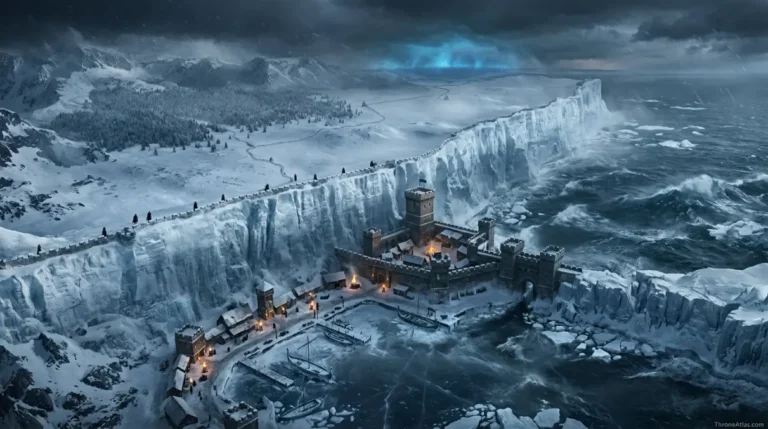
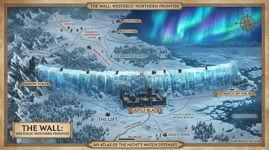
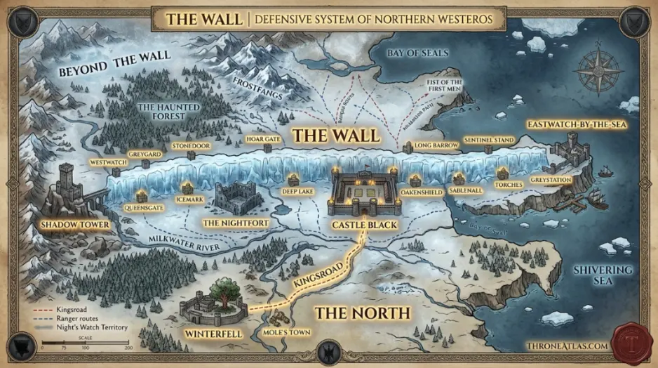
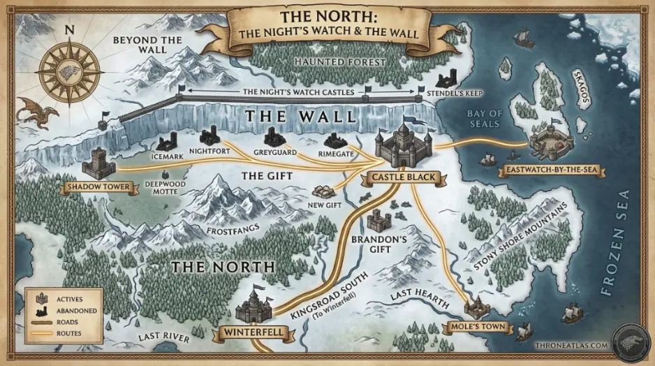
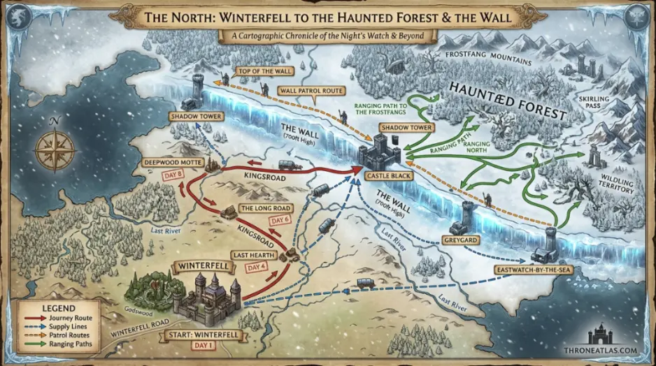
The Wall is about 300 miles (100 leagues) long and about 700 feet tall. It runs coast to coast across northern Westeros, from the Bay of Seals in the east to the Frostfangs in the west. It once had 19 castles of the Night’s Watch, but by A Game of Thrones only three were manned: Castle Black, the Shadow Tower and Eastwatch-by-the-Sea.
The Wall at a Glance
The essentials at a glance before the full breakdown.
How long is the Wall in miles?
In the books the Wall is described as one hundred leagues long, which works out to roughly 300 miles. It is the single clearest measurement George R. R. Martin gives for Westeros, which is why ThroneAtlas uses it to scale every distance on the site, from the Kingsroad to the sea lanes of the Narrow Sea.
Three hundred miles is roughly the distance from London to Newcastle, or from New York City to Washington, D.C. That sounds manageable until you remember it is a single unbroken barrier of ice, patrolled on foot and horseback by a few hundred men of the Night’s Watch.
The Wall cuts the continent from coast to coast. Its eastern end meets the sea at Eastwatch-by-the-Sea on the Bay of Seals, and its western end climbs into the mountains near the Shadow Tower, where the Gorge cuts through the Frostfangs.
How tall is the Wall?
The books give the Wall a height of about 700 feet, and in places it rises even higher where it follows the hills. A winch-operated cage lifts men and supplies to the top at Castle Black, and a switchback stair of wooden steps clings to the ice face.
The top is wide enough for a road. Patrols ride along it, and in the HBO series the defenders at Castle Black use the top as a firing platform, with barrels of oil, a giant scythe and archers during the wildling assault in Season 4.
The Wall is not only ice. Old stories in the books say it was raised with the help of giants and the magic of the Children of the Forest, and that spells woven into it stop the dead from passing as long as it stands.
The 19 castles of the Wall
The Night’s Watch once garrisoned nineteen castles, spaced along the length of the Wall. As the Watch shrank over centuries, most were abandoned. By the time of A Game of Thrones only three were still manned.
| Castle | Position | Status in 298 AC |
|---|---|---|
| Westwatch-by-the-Bridge | Far west, over the Bay of Ice | Abandoned |
| Shadow Tower | West, at the Gorge | Manned |
| Sentinel Stand · Greyguard · Stonedoor · Hoarfrost Hill · Icemark | Western half | Abandoned |
| Nightfort | Centre-west, oldest and largest | Abandoned |
| Deep Lake · Queensgate | Centre | Abandoned |
| Castle Black | Centre, end of the Kingsroad | Manned (headquarters) |
| Oakenshield · Woodswatch-by-the-Pool · Sable Hall · Rimegate · the Long Barrow · Torches · Greenguard | Eastern half | Abandoned |
| Eastwatch-by-the-Sea | Far east, on the Bay of Seals | Manned |
Who built the Wall and why?
Legend credits Brandon the Builder, founder of House Stark, with raising the Wall about 8,000 years ago, after the Long Night, when the White Walkers were driven back into the far north. The Long Night map covers that history.
The Night’s Watch was founded to man it. For thousands of years it guarded the realms of men against the Others and, in later centuries, mostly against wildling raiders from beyond the Wall.
The lands just south of the Wall, the Gift and the New Gift, were granted to the Watch to feed it. As the order dwindled, those lands emptied too, which is why the area south of Castle Black feels so lonely on the map.
How the Wall fell in the show
In the Season 7 finale, the Night King rides the undead dragon Viserion and brings down a section of the Wall at Eastwatch-by-the-Sea with blue fire. The army of the dead pours through the gap and marches south toward Winterfell, setting up the Battle of Winterfell.
Breaking the Wall at Eastwatch made sense geographically: it is the far eastern end, close to the sea and to Hardhome, where the dead had already gathered. The Night King route map traces that march.
Comparing the Wall to real walls
Martin has said the Wall was inspired by Hadrian’s Wall in northern England, which he visited. Hadrian’s Wall is about 73 miles long and was rarely more than 15 to 20 feet high. The Wall of Westeros is roughly four times longer and about thirty-five times taller.
The Great Wall of China is far longer in total, but no section comes close to 700 feet. Nothing in the real world matches the Wall’s combination of length and height, which is part of why it dominates every map of Westeros.
Riding the Wall from West to East
The three castles still manned in 298 AC, and what each one guarded.
Why the Wall Matters on Every Map
Scale anchor
At 300 miles, the Wall sets the scale for the whole continent. Use our Westeros Distance Calculator to see how far Winterfell or King’s Landing lies from it.
Political border
It marks where the Seven Kingdoms end. North of it there is no king, only the free folk.
Story engine
Jon Snow’s arc, the wildling invasion and the war against the dead all turn on who holds the Wall.
The Wall: Questions
About 300 miles (100 leagues), running coast to coast across northern Westeros.
About 700 feet, according to the books, and higher in some places where it climbs over hills.
Nineteen were built, but by A Game of Thrones only three were manned: Castle Black, the Shadow Tower and Eastwatch-by-the-Sea.
Legend says Brandon the Builder raised it about 8,000 years ago after the Long Night, with the help of giants and the Children of the Forest.
In the show, at Eastwatch-by-the-Sea, when the Night King used the undead dragon Viserion to bring down part of it.
ThroneAtlas is an independent fan-made atlas and lore reference. It is not affiliated with HBO, Warner Bros. Discovery or George R. R. Martin. Map artwork is original ThroneAtlas illustration.